Showing posts with label Core to Shore. Show all posts

Tuesday, July 31, 2012

Do we make the news?

Well, I feel like Council went quite well today. Watch for us on the news! I know I myself may end up on News9 and KOCO, as I was interviewed by one of their lovely reporters as I was leaving council chambers. NewsOK's Michael Kimball was tweeting live, and he'll have a full wrap-up. No sign of KFOR - no offense to their viewing audience, but they're probably the least likely to cover something downtown.

edit: Here is the Kimball write-up, which was indeed quite favorable to the better boulevard. It's important that the factual record stress that the earthen ramp will hinder development, which we can all agree we need more of if we're ever going to keep up with demand for housing, etc.

edit2: News9 has their coverage of today up online, and it looks very good, congrats to News9 on a well-produced story. I was pretty surprised that I made the cut personally, as there's nothing quite like seeing yourself in high definition on the evening news. I think Wenger's bit is the most important, because it really shows the engineers coming around and beginning to think with more emphasis on planning's concerns, like walkability. Could we all be singing Kumbaya down on the Boulevard?

"The people in Oklahoma City have ideas themselves, and it's important for ideas to come from all kinds of diverse backgrounds," Nick Roberts said. 
Nick Roberts with Friends for a Better Boulevard says repeating mistakes from the past will keep younger generations and growth from OKC. 
"We've also seen this boulevard get designed in a way that's going to decimate the southwest side, we believe," Roberts said.
News9.com - Oklahoma City, OK - News, Weather, Video and Sports |

(Please forgive any self-congratulating on my part, I just hate public speaking, and I'm not used to actually sounding coherent on these news reels and at City Hall.) :P

edit3: We made KFOR too (including a snippet of me up at the podium), and I heard that we made KOCO as well. I'll stop here. But it was a good one-day media blitz for sure!

Monday, July 30, 2012

Opening Arguments


With tomorrow being the day for official Opening Arguments on the ODOT Boulevard fiasco, in which ODOT wants to build an $80 million boulevard, the reason for the exorbitant cost being a large earthen ramp section of elevated freeway that will carry the boulevard over Reno, Classen, and Western avenues on the western edge of downtown. The mission of urbanists and government watchdogs is simple: To prevent this misuse of funds and redirect it instead to something that improves downtown, rather than damages it.

Downtown is important - it is where the majority of Oklahoma City's GDP is generated, it is the cultural and entertainment center of our metropolitan area, it is where young professionals moving to our city want to live, and it is the basis for the overwhelming majority of OKC's positive appearances in the national media. For fear of redundancy, allow me to stress that ODOT's earthen-ramp suburban freeways are not the basis for OKC's positive appearances in national media. Before I move on to the next point, here it is only fitting to conclude that ODOT must treat downtown uniquely from how it treats every other roadway in our state, which is shameful enough. This means that downtown, we do not need a new freeway where one was just removed, and those at-grade roadways need to be conducive to pedestrians, bicyclists, school children, Thunder/concert crowds, and just life in general. 

People live well downtown, and it shows - when you see people on a leisurely morning bike ride, or running an errand on the new OKC Spokies bike share system, walking their dog through Bricktown, or the throngs of people enjoying evening drinks on rooftops scattered across downtown. Whether or not these folks have a downtown address yet, these people are living their lives downtown - and that has been a very good thing for improving OKC's reputation over the last decade. These people do not need their lives disrupted by a new elevated, earthen-ramp freeway. Downtown's growth potential does not need to take a hit so that ODOT can move more cars than ever, faster than ever, during peak periods while the road sits empty all other times. Or more likely, downtown's future development does not need to be stunted just so that someone with ODOT ties can get a payoff as is common with their road projects. OKC's national reputation does not need to take a hit from building a misguided freeway downtown. All ODOT is doing is inducing traffic, rather than solving it, with their "our way or the highway" mentality of forcing highways on cities and refusing to even listen to other disciplines that have had considerably more success in combating traffic problems. 

This is why it is so important for a, urban planner, even if it's just one planner up against a cartel of public engineers, to have at least a say in major projects that will shape downtown for decades to come. That has not happened here. Not a single urban planner, or for that matter anyone not a public engineer, has been involved in this process.

Hello, this is ODOT, and we're going to build this highway
It all started back in 1998, when I was still a kid growing up in OKC, when City leaders first learned of ODOT's plans and tried to abate them then. Anyone wanting to know more about the timeline of how this came about, Steve Lackmeyer wrote an excellent context piece here complete with a flashback write-up that he did after ODOT chose the route in 1998, concluding with a tidbit on then-ODOT chief Neal McCaleb's disdain that the press would show up when he selected the route. McCaleb tried kicking Lackmeyer and his colleague, Jack Money, out of the meeting to no avail, and ended up settling for biting comments for public transparency. This is ironic because ODOT has predicated their insistence on the already-chosen route and proposal on "fulfilling a promise" (more like a threat) to OKC leaders back in the 90s. Even if their mumbojumbo was accurate about "fulfilling a promise," that still seeks to exclude all of downtown's growth, all of OKC's new residents, and all of OKC's <30 young professionals. When new residents and young professionals are so excluded from the public process, they are significantly likelier to move somewhere that they feel more appreciated. This is a fact backed up by studies. Yes, we should have known the boulevard would happen like this, however, we had a mayor who also lied to us when he told us the whole thing would be at-grade and conveniently excluded that Western/Classen/Reno intersections would not be. However this isn't about egos or getting the record right; This is about getting the finished product right.

Then there was the EIS. For those who don't understand public engineer jargon, the EIS is the environmental impact statement, which is required as a part of the FTA grant process (getting road projects funded federally). The EIS is supposed to outline the project scope and its impact on the surroundings, and is supposed to be finalized before the project may commence. Below is the text of the I-40 Crosstown Relocation EIS; Sections 3&5 are relevant to the Boulevard project:

3.0 ALTERNATIVES CONSIDERED"This chapter describes the alternatives and summarizes the evaluation process."3.4.1 Tier One Evaluation3.4.2 Short List of Build Alternatives RefinementAlternative D"A six-lane at-grade boulevard would be constructed in the existing I-40 right-of-way from east of the Union Pacific tracks at the I-235 interchange to west of Walker Avenue; however, from west of Walker Avenue to Western Avenue, the existing I-40 bridge structure would be rehabilitated. From Western to Agnew Avenues, the existing I-40 facility would be converted to a divided boulevard."3.4.6 Tier Two EvaluationProject Construction Time and Implementation Difficulty"Alternative D’s Phase I construction would achieve the full traffic flow benefits projected for Alternative D because only the boulevard construction would remain for Phase II."Access to Downtown"The proposed boulevard from I-235 to Agnew Avenue will provide improved access to Bricktown and the downtown area from eastbound and westbound traffic."3.5 Preferred Alternative"As a result of the Tier-Two evaluation, the ODOT selected Alternative D as the locally preferred alternative because this alternative provides a ten-lane facility approximately 2,200 feet south of the existing I-40 alignment and involves converting the existing I-40 facility to a downtown business route. This business route would maintain the current at-grade freeway from Agnew to Western Avenues and bridge structure from Western Avenue to west of Walker Avenue and reconstruct the existing I-40 facility from west of Walker to I-235 as an at-grade six-lane boulevard with at-grade intersections at the downtown cross streets."5.0 ENVIRONMENTAL CONSEQUENCES"This chapter presents potential beneficial and adverse social, economic, and environmental effects for the proposed relocation and construction of the I-40 Crosstown Expressway..."5.2 NOISE IMPACTS AND VIBRATION ANALYSIS5.2.a Traffic Noise"The FHWA has established the Noise Abatement Criteria (NAC) for various land use activity areas that are used as one of two means to determine when a traffic noise impact will occur.""When a traffic noise impact occurs, noise abatement measures must be considered. A noise measure is any positive action taken to reduce an activity area’s traffic noise impact""Alternative D’s boulevard alignment was modeled at 45 mph from Robinson Avenue to Classen Boulevard and at 60 mph from Classen Boulevard to Agnew Avenue.""As shown in Table 5-5, the projected noise levels with Alternative D would approach, equal, or exceed the receptor activity categories B and C’s NAC; therefore, this alternative would result in traffic noise impacts and mitigation measures must be considered in accordance with the 1996 ODOT Policy Directive, “Highway Noise Abatement.” This policy states that mitigation will not be considered for commercial or industrial areas or for those areas that are trending to commercial or industrial land use."5.2c Vibration Impact Analysis"There are no federal or state standards or regulations regarding traffic-induced vibration."5.3 LAND USE IMPACTS"The existing I-40 facility between the I-235/I-35 interchange and the Agnew/Villa interchange would be replaced under Alternative D with a boulevard. The current at-grade freeway would be converted to a boulevard from Agnew to Western Avenues. From Western Avenue to west of Walker Avenue, the existing I-40 bridge structure would be rehabilitated. From west of Walker Avenue to I-235, the boulevard would be a divided, multi-lane, grade-level facility with at-grade intersections with major cross streets and this is where land use impacts would occur.""The boulevard's north side for the first two blocks west of the Burlington Northern and Santa Fe railroad would front the new indoor sports arena. The first block on the south side fronts an Oklahoma Gas and Electric facility and that use is not expected to change. The remainder of the boulevard corridor frontage will consist of over six linear blocks of vacant land and approximately seven blocks of commercial, industrial, and some institutional development on either side of the facility, including parking lots. Of the vacant land, most is zoned industrial, but one block is zoned residential, and another is currently unzoned since it falls entirely within the existing ROW. Transforming the existing facility to a grade-level boulevard with at-grade access to cross streets, would provide the incentive for commercial development on vacant land and, commercial redevelopment of existing industrial properties along the boulevard would increase. The least impact would be no change in existing land use and, no requests for rezoning if market demand were to be stagnant. The greatest impact would be commercial development or mixed commercial and industrial development on all vacant lands and possible commercial redevelopment of existing industrial properties. This would require rezoning currently zoned residential and industrial properties. The current commercial zoning along the north side of the proposed boulevard between the sports arena site and Hudson Avenue is consistent with the ULI’s “Downtown Oklahoma City” plan. Those two blocks are within the plan’s designated downtown entertainment district. Similar development along the south side of the boulevard would also be consistent with the plan, given the area’s designation as a “flex” district, which is designed to capture expanded downtown development. North of the boulevard and west of Hudson Avenue, the ULI plan designates residential, loft apartment redevelopment of appropriate commercial warehouse structures. The land fronting the boulevard in this area includes vacant lots and is zoned for industrial uses. Market incentives and planning and development policies could guide new area development and redevelopment, rather than the expected commercial development. The overall effects of converting existing I-40 to a boulevard could have positive land use impacts on the downtown area."5.5 HISTORIC AND ARCHAEOLOGICAL PRESERVATION IMPACTS"Developing a grade-level boulevard serving the downtown area along the current I-40 alignment would change the SW 3rd Street Industrial District's visual setting. The change may bring the district closer to the original historic context, which included grade-level city streets. Therefore, this is anticipated to be a beneficial impact. Impacts to other historic resources would not be likely."5.14 JOINT DEVELOPMENT"ODOT recognizes the strategies identified in the City of Oklahoma City's land use and mitigation plan for implementing Alternative D. Alternative D would provide access to Bricktown's south end and downtown. Also, the urban boulevard would provide additional access to potential development sites between Walker and Western Avenues."5.15 CONSTRUCTION IMPACTS"For Alternative D, improving the existing alignment to a boulevard is scheduled after the new facility is completed. Vehicles crossing I-40 along this section would experience occasional delays or be directed to alternate crossings."5.18 VISUAL IMPACTS"Adding a street-level boulevard along the existing raised facility would also shorten the visual distance between the Riverside neighborhood and the downtown."5.19 PEDESTRIANS AND BICYCLISTS"The boulevards associated with Alternatives B-3 and D offer the opportunity for east-west bicycle and pedestrian travel, as well.""Alternative D would include converting the existing alignment to a landscaped boulevard. This proposed facility was analyzed for its impacts to non-motorist activities. Crossings, which would merit attention as possible bicycle routes, include the same facilities as for Alternative B-3 (Agnew, Pennsylvania, Western, Walker, and Robinson Avenues and Shields Boulevard), with the addition of Reno and Classen. The facility would cross the Bricktown Canal Trail, but would present no greater impact than the existing I-40 facility. Using the I-40 ROW as a boulevard would have slight or no impact upon non-motorist access to nearby public schools. The current alignment is a boundary feature for Capitol Hill, Wilson, and Shidler Elementary School feeder areas, which means that students attending these schools should not have to cross the boulevard. The boulevard alignment is a prominent feature in the Mark Twain Elementary School feeder area. Although changing existing I-40 to a boulevard would result in a less imposing physical barrier for non-motorists, a boulevard would present greater opportunities for non-motorist conflicts with motorists than the present limited-access configuration. These conflicts could be minimized by using signalized crosswalks to allow non-motorist crossings without vehicular turning movements. Other possible safety measures include bicycle lanes, intersection design with places for pedestrians to stand at street corners and on the median, all-way red lights for pedestrian crossings, and raised crosswalks where larger pedestrian crossing numbers are anticipated. Because other existing pedestrian and bicycle activity centers, including downtown, the Myriad Center, and the Bricktown District, are concentrated north of the existing I-40 alignment, using the present I-40 alignment as a boulevard would divert vehicular traffic away from these non-motorist activities and result in improved safety. The bicycle/pedestrian impacts of the proposed boulevard along the present I-40 alignment would likewise depend upon the ultimate facility design. While a boulevard potentially would represent more opportunities for non-motorist conflicts with vehicles than a controlled-access highway, abutting boulevard land uses and facility design would also be important considerations. Facilities that attract special-event, tourist, shopping, and cultural activities, would necessitate slower speeds and painted and signalized crosswalks. Additionally, where warranted by the pedestrian traffic levels, elevated crosswalks should be considered. Through traffic will be encouraged to use the new I-40 alignment."5.23c Economic Impacts"The property tax base in the affected study area could be enhanced by potential commercial development and redevelopment in available areas along the proposed boulevard under Alternative D."5.24 ADDITIONAL MITIGATION"Downtown access concerns have been addressed by identifying three boulevard options associated with Alternative D. These options included maintaining the existing I-40 facility; constructing the six-lane at-grade boulevard from I-235, east to Agnew Avenue; and providing a modified boulevard combining the other two options. The preferred option is the modified boulevard that provides a downtown business route. This option involves retaining the current at-grade freeway from Agnew to Western Avenues and bridge structure from Western to west of Walker Avenues and reconstructing the existing I-40 facility from west of Walker to I-235 as an at-grade six-lane boulevard with at-grade intersections at the downtown cross streets." USDOT - RECORD OF DECISION"The decision is to select the preferred alternative, Alternative D, as described in the FEIS.""The selected alternative will provide a six-lane at-grade boulevard in the existing I-40 right-of-way from east of the Union Pacific tracks at the I-235 interchange to west of Walker Avenue. From west of Walker Avenue to Western Avenue, the existing I-40 bridge structure will be rehabilitated. From Western Avenue, west to Agnew Avenue, the existing facility will be converted to a divided boulevard."
In case anyone is confused by all of this jargon, I highlighted the parts of the EIS that are incorrect and in need of updating. Why is this relevant? Why does any of this matter? Because ODOT is claiming that they can not do an at-grade boulevard all the way to Western because they have to fulfill their obligations in the EIS, not that this has ever mattered before for ODOT (they broke the hell out of the EIS for I-235 in their quest to demolish downtown's black community, Deep Deuce, in its entirety). So not only is the moral of the story that ODOT lies, but also that ODOT expects us to not read this stuff, to just go away eventually, and let them get back to their work. The most glaring omission is the fact that the old Crosstown viaduct no longer exists, and therefor it is not possible to "rehabilitate the existing bridge structure." The EIS needs to be redone anyway, and this is hardly an impediment specifically to changing the plans to make them more urban. If the EIS has to be redone, causing delays on the project that will be justified to get it right, it will not be because OKC demanded a Better Boulavard, but instead because the Feds decided to reign in ODOT which has a long, storied history of breaking these documents. But it's okay ODOT, Mick Cornett and Eric Wenger also have a habit of telling lies.

Furthermore, they conclude that the boulevard has little impact on schools because it is nowhere near any schools. This is inaccurate as well due to the construction that will begin next year on the new Downtown Elementary which will back-up to none other than the BOULEVARD. Nowhere near any schools, right.

Opportunity squashed
Due to the new I-40's only downtown exits being at either Shields/Robinson or a full exit at Western Avenue, where the majority of people entering from SW or NW OKC come into downtown, Western Avenue is now the front door to downtown. It is our less-than-grand entrance to downtown. Blighted for blocks, congested and jammed like no other city street at 5 o'clock, Western has traffic counts to make development happen - all of those downtown workers taking Western to get on the highway heading home will stare at whatever properties line the ROW, so they might as well stare at redevelopment.


The group, Friends for a Better Boulevard, of which I am certainly informally a part of, has envisioned a grand entrance to downtown where people currently sit in traffic along Western. They are proposing the Market Circle, along the Boulevard at the Reno/Classen/Western intersections, and the Thunder Circle, along the Boulevard in between the Chesapeake Arena and new MAPS3 Downtown Park. In the Market Circle the pro-bono architects have envisioned an arch way that gives OKC the opportunity to realize a turn-of-the-century plan by legendary architect Solomon Layton (State Capitol, Colcord, Skirvin, et al.) to have a Veterans Memorial Arch in the middle of Lincoln Boulevard. Those plans, along with the Capitol dome (a bad idea) were never realized. However, often the best new plans incorporate good old ideas, that came about for a reason. This traffic circle proposal will catalyze a boom of dense development west of downtown and generate significant economic development for OKC. Here is an excerpt from a recent article by Lackmeyer on Film Row and west downtown's development boom (this quote is Film Row redeveloper Chip Fudge talking about several building projects and predicting that south of Film Row will be a hot spot):


With all this activity, and Devon Energy Center in the foreground, friends are no longer mocking Fudge for plowing his money into “skid row.”
“Life is good,” Fudge said. “My friends who thought I was nuts for doing this initially now think I'm brilliant. Really, I'm just lucky. We're continuing to buy property in the area. And if the boulevard (planned along the alignment of the old Interstate 40) goes in at ground level as I expect, I think the area south of here will be the next hot spot.

Read more here.


There is also the matter of the Farmer's Market, which is what lies south of Film Row, and concurrently the city and a group of citizens are trying to revitalize. Currently it has been repurposed as an events center taking advantage of its beautiful mission-style architecture, but there may be plans in the future to bring back a permanent outdoor market and engage historic redevelopment in this area. The Farmer's Market is an extremely historic center of commerce for OKC, and my own grandfather used to work there long ago. In fact, back then, the entire clan worked there selling produce which was not a bad living back before WWII. The Farmer's Market was a magnet of middle class life in Oklahoma City back then, just as the once-beautifully landscaped Canadian River waterfront was with Wheeler Park and Delmar Gardens. This market-area masterplan seeks to bring back both the tranquility and the commerce:


Unfortunately for ODOT, all of these are things we are not willing to sacrifice just so that ODOT can pay somebody off and move on more easily to the next project. All of these visions, especially the hope for a grand entrance into downtown, and also the hope to revitalize the areas south of downtown such as the market area and the riverside, are all endangered by this elevated freeway plan. This is also a plan that was most recently articulated by highway engineers who weren't aware that the streetcar would run on rails in the Boulevard. How do you get through to these people, as oblivious as they are, aside from political means? At the state level it is time to pursue correcting and reforming ODOT, but in the interim, at the civic level, we have to engage to protect our city and any other plans ODOT simply isn't aware of.

Those seem to include the Downtown Elementary, the Downtown Streetcar, Farmer's Market revitalization, Core2Shore revitalization, Film Row/Arts District redevelopment, and the very idea of downtown development on the whole. All of these ODOT is either ignorant or hostile to, and all of these kinds of projects have proven to be the essential ingredients in the recipe for an OKC reborn. What does OKC reborn mean and why is it important? Because too many of us remember a river that had to be mowed, too many of us remember wrestling and minor-league arena football being the main attraction in town, too many of us remember Wal-mart being the only place to shop, and too many of us remember an OKC that was essentially no more than an extended truck stop between LA and Chicago. Today those are merely insulting reminders of how far OKC has come in its quest to justify itself as a "big league city" and even cast itself in similar fashion to truly "world-class cities."

The ODOT earthen ramp is not world-class, hell, it's not even bush-league. It is embarrassing. ODOT has pushed OKC around too much for the last two decades, and it's time for OKC to take a stand. They bulldozed all of Deep Deuce, the downtown black community, and built a suburban depressed freeway (I-235) where there used to be a dense, urban neighborhood. They forced the I-40 Crosstown Relocation against the city's will. Then, they decimated the railyard behind Union Station which will add billions in cost when we get around to building the commuter rail that is planned, which the city idly watched them do, while a few enraged citizens went away kicking and screaming (Tom Elmore). Now they are taking our best site for urban redevelopment and giving us a highway mound of dirt and grass that will have to be mowed while it isn't dead and brown, like grass all over Oklahoma.

This isn't the revenge of Tom Elmore. This is the culmination of ODOT's years-long recent legacy in Downtown OKC, and a decision that needs to be made whether we want to hear only ideas that come from highway engineers or if urban planners should also be brought into the fold. Urban planners and design specialists, being the folks who gave us entertainment in Bricktown and large-scale gentrification in what was left standing of Deep Deuce, Automobile Alley, and Mid-town. Today these areas are surprisingly decent and growing better with each new development, despite the unfortunate past these areas have endured until now. The choice seems pretty simple.

Wednesday, July 25, 2012

Paging any planners

One thing had me wondering about the proposed Boulevard plans. Has there been a SINGLE individual with a degree in urban planning, regional planning, urban design, environmental design, etc. (ie., anything BUT civil engineering) who has said that the boulevard should be elevated? Can anyone name someone? Anyone? Just one person??

(Of course that's a rhetorical question, because we're referring to a boulevard that has only come about through sparse cooperation with ODOT and OKC Public Works.)

How can we make such a major decision in our city planning without input from a SINGLE individual who actually has a degree in anything planning or design-related. The thought of the elevated boulevard is repulsive. The thought of such major decisions, not just failing to include, but actively patronizing those who do have planning or design expertise - that goes beyond this boulevard, and is a much more serious issue.

Something is rotten in OKC right now. Very rotten.

Friday, July 20, 2012

Roundabout reservations

Many readers and folks beyond know that I've become one of many side advocates of Friends for a Better Boulevard, and I support almost everything that has been said by Bob Kemper and others that have gotten very entrenched in that fight for a better boulevard for OKC. That said, I concede that I was erroneously espousing the term traffic circle when what has really been envisioned is a roundabout, and there is apparently a very major difference between the two.

To paraphrase, a roundabout is a perfect circle where entering traffic yields to everything else and exits right to leave the circle. A roundabout is more of an orbital intersection, less of a perfect circle usually, where the lanes flow out and staying in the roundabout requires left turns. Roundabouts can efficiently handle a large volume of traffic but can not safely accommodate pedestrians, whereas traffic circles are the opposite.

Here is a chart created by WashU and distributed by Friends for a Better Boulevard (click to enlarge):


This looks fine and dandy, but I think it raises questions as to which of these we really want. I agree that this intersection will have to handle large volumes of traffic, but I am uncomfortable with it doing that unless major design concessions are made to promote walkability in and out of the circle as well. Why would we put an arch and a park in the middle of this, just to improve the view that motorists have, esp if people can't get to it?? I'm wondering if there is a way to engineer a hybrid roundabout and traffic circle.

Let me make one thing clear before I even open up this can of worms, and before anyone accuses me of straying from the reservation: I support whatever the consensus alternative is to anything above-grade. I just also agree that this debate needs to play out. For instance, while I love the amazing renderings produced by Andrew Stewart, who has also been helping the group, the bone I have to pick there is that Western Avenue does not flow into the circle. For me, Western Avenue and its high traffic counts, high prominence, high blight factor, and huge rent gap potential for development, is one of the main reasons to do this intersection RIGHT. I want to be on the record supporting the movement in its entirety and I support whatever a public process would yield, that said, I am looking to see Western Avenue flow directly into a circular roadway that can also accommodate pedestrians. A circle of some sort that does not accommodate Western OR pedestrians is only half as sweet.

Having made my unconditional support clear, I keep going back to the name "better boulevard." To me, a better boulevard means something other than the strict and narrow purview of what is better for motorists. I am looking for what is better for pedestrians, for bicycles, for transit, for quality of life, for the environment, for economic development, and the entire city as a whole. While there is no doubt that a roundabout is far superior to those ends than an earthen ramp or anything above-grade, I would also suggest that an old-fashioned traffic circle may be even better. IF there is a way to make a traffic circle work for high traffic counts.

Thursday, June 21, 2012

Western Avenue gridlock

Stuck in traffic for a good 20 minutes on that half-mile stretch of Western Avenue between Sheridan and the new I-40, I made a mental note to myself to revisit a post that I made a while ago. Western is routinely gridlocked during this half-mile stretch, and I myself was surprised that the new I-40 project's completion has actually finally given OKC the "big league city" rush hour that we all craved. Ok, or not..

However I think that this is an opportunity, not a problem (although trying a different synchronization pattern with the lights along Western may be a good idea to ease traffic circulation). It's an opportunity because these kinds of traffic counts don't exist anywhere else downtown, and even though Western is definitely the blighted back entrance to downtown, at least with this kind of bumper-to-bumper congestion and the corridor's newfound prominence, that lends a majority opportunity for the Market Circle proposal to take advantage of.

I happen to believe (call me crazy) that development should follow traffic counts, rather than try to magically manufacture them. Western must be redeveloped, the gridlocked rush hour traffic that only exists here is screaming for it. Imagine the exposure that a business would get if somebody is stuck sitting in their car for 5 minutes just in front of that business alone. Then gets to crawl up another hundred yards after a few lights turn green, and gets stuck for another 5 minutes staring at a different business. I think this is the kind of traffic that could actually make downtown destination retail (ie., another subject we've talked to death on here and around town) very viable, although as far as that goes I am still bullish on North Broadway and the A-Alley area, especially if they can get a public parking solution.

Here's the photo from NewsOK that shows you what Western becomes every single weekday between 4:30 and 6.


I think at a certain point, you have to stop basing your planning on how you understood downtown in 1990. Downtown has changed and evolved since then; downtown is dynamic. The new reality in 2012 is this. Take advantage of that new reality.

Tuesday, June 19, 2012

Market Circle renderings are IN!

Without saying a lot (I'll let the renderings, just completed by OKC Talk's CuatrodeMayo aka young architect Andrew Stewart, do the talking), I will just say that I think this marks the evolution of Friends for a Better Boulevard as one of the most dynamic local movements in recent history, perhaps second to only the Modern Transit Project. Could Andrew be the traffic circle's Jeff Bezdek? I doubt he wants that kind of commitment, I know I would be freaked out, but I also know that Andrew is very committed to seeing OKC evolve into the kind of community he and his young family can prosper in.

Please, click on these renderings to enlarge to full-screen, they're worth it:


Wednesday, June 13, 2012

The stakes

Higher than any poker game we've played lately..


So you've heard..

Great mention for the traffic circle movement on Kurt Hochenauers Okie Funk blog (Kurt used to write for the Gazette, idk if he still does) today - really summarizing what a movement this has become, with MAPS3 transit subcommittee members lending their support and enthusiasm for this city, myself, former ODOT engineer and consultant Bob Kemper really leading the charge, Councilman Shadid getting behind the idea in a big way, OKC Talk is buzzing about the idea, and so many more people. This is truly evolving into an organic preemptive strike against a huge blunder that is about to be made.

What really needs to happen is ODOT needs to wash their hands of this project and just give the funding over to the city and let the city do whatever it wants. I don't think ODOT is actually on a mission to screw up downtown OKC - Bob thinks they are concerned about going over budget and the city not wanting to maintain something. The solution here is easy, there is significant extra funding that the city has from the 2007 GO Bond Issue, and ODOT can just give the $80 million for the boulevard to the city and not worry about any more cost overruns (although that clearly wasn't a problem for them with the new I-40, which ran 3 times over budget and still isn't a depressed roadbed, just as they knew it would all along). There is also an extra $30 million in MAPS3, in addition to contingency funding there (that will likely go to the convention center when it comes in way over budget).

Anyway, here's the latest illustration that I have come up with for how this roundabout could potentially fit into a grander scheme.


I'll just add that this is also a work in progress, and definitely stay tuned. There's something else that we're going to roll out here in a few days, and we're hoping that we have a proposal that the entire community can really get behind, regardless of whether you want a premier center city or not. I've always believed that OKC can so easily be a first-rate center city, the bones are there, it just takes everybody realizing it and getting on the same page - which unfortunately is so much easier said than done.

And yes, my "grand scheme" for a better boulevard definitely involves moving the convention center to a location that is better for everyone, but that's not what this is about. This is about the roundabout, I just happen to take a holistic approach involving the entire boulevard. What happens west of Lee Avenue, in my mind, affects everything to the east.

Let me close by saying that I absolutely believe that everything in my illustration above can be accomplished with funding already committed - including MAPS3 funding, including 2007 GO Bond funding, including ODOT's committed funding, and including private funds that people have proposed going toward cultural institutions and private development. For those who don't know, the Kirkpatrick Foundation is moving the City Arts Center downtown, just not anywhere near the Arts District which I think is an unfortunate oversight of synergy, which is so important for the arts - and Fred Hall among others did talk about a major private development replete with mixed-use and high-rise residential (possibly the largest mixed-use project in state history) on the site that is now taken by the convention center.

Why can't we piece these things together from the perspective of what creates the most impressive, healthiest boulevard corridor, rather than what creates the best convention center? There are more important things than just a convention center, in the grand scheme of city planning. This boulevard, if we do it right, has the potential to pay dividends for OKC in terms of postcards, private development opportunities, and civic pride. Let's do this the right way.

Sunday, April 1, 2012

Hubcap Alley?

Does anyone know anything about a mostly-complete streetscape project along South Robinson from the new I-40 all the way across the river, down to Capitol Hill? I have not seen this personally myself yet, but I have been told that it actually looks pretty good and highlights the enormous potential of this area of Core2Shore.

I've also been told that there is red branding signage attached to new street lamps that look really similar to Automobile Alley, and they say "Hubcap Alley" on them. This, along with historic-themed black streetlamps (interesting, I distinctly remember a C2S presentation with Hargreaves looong ago in which city officials were all in unanimous agreement on the need for modern branding in C2S) arranged 2-per-block, which also required the sidewalks to be rebuilt between I-40 and the river. Also interesting considering that the Film Row streetscape didn't get street lighting until lately and only after public pressure, and yet the much-more dubious South Robinson gets them under the radar.

Apparently this was budgeted into the 2000 G.O. bond projects, and with the black hole created in downtown traffic circulation created by ongoing capital projects, it's no surprise that this streetscape went in so under the radar.

Wednesday, March 21, 2012

A very fluid MAPS 3 in transition once again...

I think we're seeing yet another possible shift, and possibly another complete bastardization, of MAPS 3 as we know it. Two important references for you to read, and I'll provide my commentary and background angle later:

Lackmeyer article & Bombshell C2S/MAPS3 study from ADG

OK, well I lied, there's three because Mike Mize took some..uh..liberties with his C2S impact study, and somehow finagled it to attack transit (kill two birds with one stone, I guess).

Transit subcommittee official response to ADG study

Tuesday, December 6, 2011

Bulldozer-happy morons strike again


This building was targeted by demolition earlier because the convention center super-block was going there. Instead, that convention center super-block got moved to just about the only potentially worse site they could have come up with.

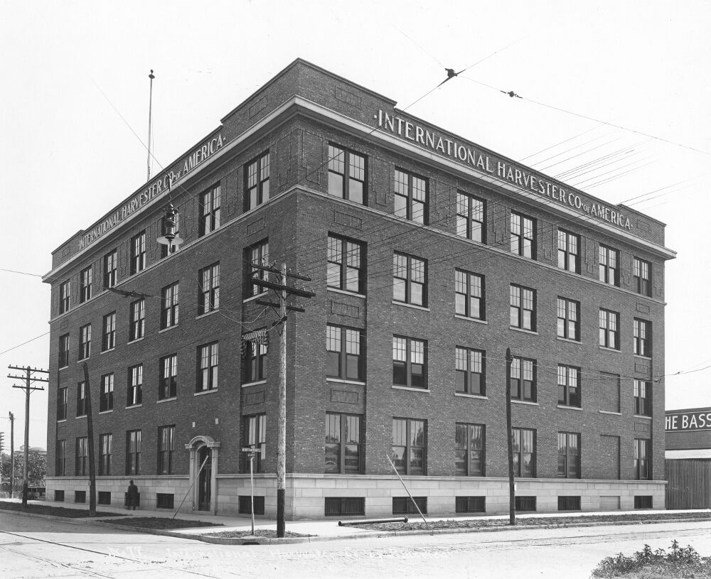
So why is the International Harvesters building still on for demolition? This is yet just another great old building coming down. This city is becoming demo-happy as it was in the 1970s. Deja vu. Anyone who claims to be pro-preservation is just offering up lip service.

I'm just not sure this city is interested in historic preservation, urban design, sustainable development, and quality environments. And the means in which this city throws slings at those things are ridiculously over-funded (convention center) and the means in which they claim to care about those things (streetcar, parks, streetscapes, etc) are ridiculously under-funded by comparison.

This building is in the C2S region. There is also a very good corridor of historic buildings along SW 3rd with great potential. It will also likely be leveled if certain folks have their way. I'm beginning to think C2S is a disastrous undertaking that should have never even begun, not for the bad it looks like it is going to do, and not even for the supposed good we were told would come out of it.

C2S is nothing but an urban planning folly and a sham at that.

Sunday, November 27, 2011

Incredible incompetency downs Automobile Alley project

Read more in Steve Lackmeyer's recent article about the stunning City Hall incompetency and misplaced priorities that downed what would have been a major development deal at Broadway and 13th. A large Houston-based development company that has had successful urban developments in Tulsa wanted to invest $38 million in Automobile Alley, giving it the jolt of mixed-use development it needs to continue growing.

The city shifted funds for a needed railroad quiet zone for land acquisition in Core2Shore. No wonder they started making progress on C2S so soon. We are now truly prioritizing this nonexistent area of the city AND convention centers above things that people actually want like TRANSIT and improvement to existing neighborhoods of downtown first.

This Cornett City Hall is loosing its luster every week. What it needs more than anything is for someone else to have another major success that they can take credit for again in order to retain popularity.

Wednesday, March 23, 2011

Maybe C2S needs to be scrapped

I am thinking more and more lately that Core2Shore needs to be scrapped. Not even pursued. Not a dime spent in that direction, even though it's too late..

These are the reasons: Yes, it would be nice to have a model contemporary, urban city. Yes, C2S is a neat opportunity to build that. However, I don't trust OKC to build that. I don't trust OKC to turn what is essentially brownfield into a model urban city.

The urban boulevard would have been nice.

The urban central park would have been nice.

The convention center located across the tracks would have been nice.

The urban waterfront would have been nice.

All of these things and more would have been nice.

All of them are being screwed up. Either there is a grand conspiracy to prevent urban from ever happening, or this city is simply clueless when it comes to building urban things.

Consider the boulevard. It's not going to be anything close to a model urban boulevard. The city is insisting that someone other than the city pay for it, and that means ODOT--so it's going to meet their specifications for new roads. It will have super-wide lanes, 6 or 8 lanes, and it will have pedestrian tunnels and bridges encircling it in every direction. Not people-friendly at the street level. The boulevard is already going to be a cluster, there is nothing that can happen at this point to mitigate that. The plan for that is already set in stone. The city could tell ODOT last minute to drop the project and the city could pursue it on its own, and build a much simpler boulevard on its own, but that isn't going to happen.

Consider the central park. This last week the council voted to do a new pedestrian TUNNEL underneath Robinson, presumably, between the convention center (the site the mayor is HELLBENT on) and the central park. First, I was bracing for the impact of the park just being a front lawn for the convention center. I had no idea they would take that even further and have tunnels leading from the front door of the convention center to practically the middle of the park. That is turning out to be a nightmare worse than I would have ever imagined. You don't even at least have to cross the street there. Oy veigh...

What is wrong with crossing the street? Why do we need all these pedestrian tunnels and bridges? Are we planning for some alternative future universe where humans will no longer be born with 2 legs that work?? Unless we're trying to get people across I-40 or across the tracks, that seems totally worthless and unneeded. Why are we spending money on that? Ugh.

What is wrong with simple 4-lane boulevards (2 in each direction) with a wide landscaped median or something? That would cost a fraction of what this street-level superhighway that meets ODOT specs is going to cost. It would be less of an urban nightmare, as well.

This city does not need Core2Shore. It doesn't need anywhere new to build a park and a convention center, even though the park is already being built. It doesn't need any more available land downtown. Downtown already has a huge inventory of vacant lots and abandoned buildings that aren't close to finding uses. I am scared at what OKC is going to end up building in C2S.

And I'll tell you how this will end up: It will just be a continuation of the superblock cluster. There will be virtually zero mixed-use development around the park or anywhere in Core2Shore. It will be parking enterprises and low-impact development like maybe a few restaurants and maybe a convenience store. It will have all these super-wide streets and million-dollar infrastructure pieces that nobody uses unless there is a big convention or a big event in the park. It will be absolutely dead. It will feel like an expensive, government-built ghost town. It will go down in history as the biggest urban renewal folly since the 1970s, anywhere. It will absolutely fail to attract private investment because people will not want to go there. Everything in it will probably be named after Mayor Cornett.

That's not a legacy I would want. Perhaps it is absolutely for the best that the MAPS3 Convention Center Subcommittee decided to scrap the two C2S sites from consideration. I would much rather see what they can do within the context of an existing area, which will at the very least put limitations on the project. More limitations are what we need as long as somebody very high up is listening to morons who know nothing about urban planning.

Tuesday, February 1, 2011

Major irony

Anyone else notice the irony in the convention center study that council just approved? More on this later. Just a tease...

Hint: Go back and review groups that have conducted all of the prior studies on the convention center.

____________________

There answer is that the study is going to be executed by Populous. Populous is a spin-off of HOK, which is a large consulting firm that is probably the #1 experts in the field of arenas, stadiums, and convention centers. HOK did a convention center for us a year or so ago before the MAPS3 vote. So now the convention center studies are officially coming full circle. I wonder if this will even have the exact same people, exact same criteria, but shockingly different results?

I wonder what is going on...

P.S. It's also interesting, but maybe just to me, that Populous lists their Norman office on a page with the header "Kansas City Office" and uses a graphic that is basically the Calgary skyline, taken from the Stampede. They don't list an office in Calgary.

Saturday, December 25, 2010

Christmas Wishlist 2010

As today happens to be Christmas Day, I thought I would take some time to lay out my ideal wishlist for OKC. It could be a lot longer obviously, as virtually everything could be done differently, more efficiently, and better. But I'll stick to the main points:

1. One thing I wish for is a serious Plan OKC process. In the coming weeks I am going to be trying to get together an urbanist group to do a Plan OKC "Meeting in a Box" over one evening. I would actually like to see OKC implement some innovative ideas (maybe even some that would make city planning conspiracy theorists' eyes bulge) that could legitimately curb sprawl. I'd like to see us creating fewer places devoid of real lasting value (thus creating future SLUMS) and like to see us move some more of our growth into the kind of development that will still be nice 30 years from now, and even still standing 100 years from now. I'm tired of cheap and low-quality being Oklahoma City's best selling-point. Even if that means prices are going to rise, we have to find a way to start building quality communities and to stop building slightly better than crappy communities. A friend once told me that OKC's motto is, "Better than crappy makes us happy." It's true, and how said is that?

2. When it comes to one of OKC's latest greatest projects with a 7-digit price tag, I'm not even going to say I hope for any kind of abstract, feel-good process with the convention center like an open or transparent process. I could care less about that at this point, because the bottom line is that if the convention center is right next to the park with no separation, it will ruin the park environment. If they think putting commie block apartments in the convention center facade is going to work, they must be kidding themselves. A convention hotel is not a mixed-use from a convention center, either. They need to either put the convention center somewhere else or if they insist on the mysterious OG+E payments, then they need to utilize my creative solution to set it back an entire block and bring Broadway back, allowing for a slender 1x4-block district to develop in between the two. The ULI panel noted that the convention center is being put on 40% more land than it needs, even if it's going to be expanded. Furthermore, I'm tired of the suburban thinking behind Core2Shore. There are block sizes and human scales that actually matter downtown. I get it that they don't understand or care about this, but you can't just recreate a site identical to what you'd do in the suburbs and put it downtown. In the suburbs you wouldn't notice an area (similar to what would end up running all the way from Park Avenue to Oklahoma River) that consists of over 100 normal sized city blocks consolidated into about 15 huge superblocks. Right now we have a large cluster of superblocks that has killed downtown, and ALL Core2Shore looks like it will do at this point is extend that huge miserable cluster further south. Has anyone noticed how the Myriad Convention Center and the Myriad Gardens interact with eachother?? "Oh, but it will be different this time.." If anyone buys that the nature of superblocks have changed, or that they can do the exact same thing and get a better result, they need to be locked up in the mental ward. Or shipped to Tulsa.

3. Come on Nick, tell us what you're planning. I mean Nick Preftakes, not myself. Years later I am still dying to find out what Nick Preftakes is planning to do with the entire block he bought up in the Arts District. I've been telling people it's going to be a game changer, especially with Devon Tower+park+retail+auditorium and the emergence of the Film Row area (which is coming along very nicely), the Arts District could potentially be unrecognizable if Preftakes announces a major development there. It will be absolutely essential that he maintains the historic integrity of the very-historic block, but there are some boarded up buildings there with some really amazing potential. It would be so worth it, especially when you look at the new lease on life the old Montgomery Ward building across the street got. The unfolding of these plans could potentially affect other things like the streetcar route. I've been telling people that I think the Arts District could potentially be a much bigger deal than it is now.

4. I want to see development in Bricktown get back to where it could be. I wish for Bricktown to come closer to being "completed" because once other districts get hot, it may never be able to attract more development. The big problem is that in my opinion Bricktown has gotten stale and has failed to reinvent itself in a long time, and in today's world, that can be fatal. Bricktown could suffer the same death that the West End did for a period if it fails to reinvent itself and stay fresh. It's not just for the sake of locals who have started to focus more on districts that are hotter right now, but for developers who are comparing cheaper asking prices somewhere like 10th Street or Broadway to astronomical ridiculously inflated asking prices in Bricktown, and the choice to pass on Bricktown becomes an easy one. I think Bricktown is relying too much on the streetcar spurring development along Sheridan to bother pursuing other ideas. The city absolutely is to blame, not the Bricktown merchants that put their money where their mouths are. Just because the ballpark and canal are in Bricktown doesn't mean that it's reached some invisible limit for how much city assistance a neighborhood can receive. Has the city turned its back on Bricktown?

5. The Bricktown point is a great segway into parking. Simply put, two things need to happen: It needs to be expressly codified into the city statutes that new surface parking downtown will not be tolerated, especially in lieu of previously standing buildings no matter the condition of said building, and parking lot moguls in areas like Bricktown need to be shut down and put out of business. Tell them to take their business to Tulsa or some city that will tolerate that, but we won't here in OKC, because a few of us are actually serious about building downtown up. How do you shut down the Bricktown parking lot lords? Public parking, and that can be done extremely easy. Watch closely a project that is underway with Automobile Alley to re-stripe North Broadway and take away a lane, add a turning lane, and change parallel parking to angled parking which will allow them to squeeze in hundreds more parking spaces. If they went with angled parking along every Bricktown street that is free or metered, they could easily shut down the Bricktown parking lots because more than enough parking would be available for free on the street. This should also be pursued in other districts if the results in A-Alley are as positive as it could very well turn out.

6. Oklahoma City has failed to grow downtown housing to the extent that we had hoped we would have by now. This is a simple fact in spite of the other fact that downtown housing is slowly on its way to becoming viable, with several hundred downtown residents moving in and taking up urban lifestyles. It could be more, it should have been more. The 2005 Downtown Housing Study said there was 5-year demand for thousands more units than we ended up getting built between 2005-10. Another downtown study that came out right around there recommended taking several steps to incentivize downtown development. Virtually none of those steps, except for rezoning, were actually followed through with. I assume the copies of it at the Planning Dept got filed in the big file cabinet full of other ignored downtown studies and surveys and reports and commissions. But it may be time to develop a REAL program designed to result in a boom in smaller infill projects. This needs to happen now, so that we can fix the problem with demand, before streetcar comes on line and results in a huge boom in infill and therefor makes the appearance of a problem go away. If we get the streetcar finished without an infill program, the results aren't going to be as positive as it would be if we got the streetcar in and an infill program. We need to evaluate our goals from 5 years ago, and the results we got, consider why it ended up that way (and be open-minded to reasons other than the popular excuse, "It's the economy, stupid"), and get back on track to recover lost projected units.

7. I want to see Full Circle move downtown. They could locate smack in between Heritage Hills and the booming downtown residential market. Downtown residential markets tend to be filled with creative types with disposable income WHO READ. If they went into a beautiful old building like The Packard at 10th/Robinson they'd have the potential to be one of the absolute coolest locally-owned bookstores in America. They already are, the only thing holding them back is their location in crappy (and rapidly-emptying) 50 Penn Place. Enough said.

Well that's the Top 6 at least. Quick summary: 1, Plan OKC; 2, convention center location; 3, Nick Preftakes development; 4, Bricktown development; 5, angled parking; 6, small infill program; 7, Full Circle.

I am thankful for all the really good things going on in OKC, for being included in a number of processes unfolding around downtown right now, and it's also good to be back in town. If anyone's interested in meeting for coffee or lunch, feel free to let me know, I'm always excited to meet with fellow urbanists. I know this blog doesn't get a lot of comments by the nature of the things it talks about, but I do appreciate the people who read this and hear me out on the ideas I have. Merry Christmas to all!

Sunday, December 19, 2010

Convention center search: Site selection nearing

The city is currently undertaking once again, another convention center study. There has been a number of highly-acclaimed consultants who have vehemently advised against the parkside convention center site. There was an OU presentation that proposed other potential sites, such as the Bob Howard Ford site north of the proposed boulevard and the steel yards in the east end of Bricktown. There have even been some Bricktown merchants surprised by that idea, and the steel yards are not a bad idea because it provides good access to Bricktown and doesn't block circulation because the site would just back up to 235. I don't think the idea will go very far though because it is nearly a mile from the CBD, which is just too far.

I also don't think that the Bob Howard site, the closest proposed site to the current CBD, is going to go very far. Fred Hall announced that he's closing his family's dealership last month and is going to pursue a massive mixed-use development of the entire 6-block site, which spans from Walker all the way to Robinson, from Reno to the proposed boulevard. One of the few vital components of the Core to Shore plan that is universally agreed on is the need to focus the signature retail on that site, and Fred Hall, with his resources and connections, is just the guy to pull it off, so that's great for OKC. I don't think Mayor Mick wants to put the convention center there because he was quoted in the paper saying it would cut off circulation to downtown, which is incredibly true. I don't think that the proposed site along East Main in Bricktown works either, although it's an interesting idea--putting it in the parking lots north of the East Main storefronts.

With that said, it looks like it should be south of the boulevard. That's by process of elimination, unless someone with credibility seriously comes in and suggests Meridian or something both suburban and nutty.

Moving on, this a brief critique of the parkside site:

This site can not be allowed to happen for many reasons. The obvious one is that the park frontage would be squandered. A convention center does not bring the vitality we want surrounding the park, and the idea of having apartments in the facade of the convention center is not an innovative solution to the convention center problem. Pretend we're not even talking about a convention center, any kind of structure that is not broken up and 2-3-4 blocks long would have a negative effect, looming over the park. Hell, even if it weren't convention at all and were all apartments, a 2-3 block-long apartment building, basically an upscale commie bloc, still isn't exactly the development we're looking for. A mix of commie blox and convention center, I imagine, will have an effect fairly similar to a commie bloc and a convention center. As mentioned by the ULI report, it creates a dark wall effect and will cast a shadow on the park in the A.M., also something people will overlook but would have a potentially devastating impact on enjoying the sunrise in the park. The HOK report, another one of the many studies done, is no fan of the access to existing assets from the parkside site.

Jeff Speck though, another consultant, brought up the trump card, and probably the biggest concern for the parkside site. Superblocks. There are too many superblocks clustered together. In the above graphic, you'll notice I shaded the area of sueprblocks: in a huge cluster from I-40 all the way up to Park Avenue, there is not a single normal downtown block (except for the block with Devon's HQ and the Renaissance Hotel). A whole damn mile of urban renewal's effects. That would be truly devastating on the chances of spending all this money actually creating a world-class city. Never underestimate the importance of the little things, like the street grid. A street grid is extremely important, it impacts how the city flows. The reason the area south of I-40 died is probably not because of the I-40 land bridge itself, for proof, check out Omaha--a nearly identical city in many ways, that is seeing a lot of development in their "NoDo" area which is just on the other side of a very similar huge land bridge freeway.

The difference is that it lacks what likely did cause the death of downtown's south side--the superblocks simple cut it off from the rest of downtown. We have the Century Center, the Cox Center, the Ford Center, the Myriad Gardens, and EKG all clumped together like that. It shouldn't take a rocket scientist to tell that such a configuration of all these superblock sites right next to each other will likely cut off the circulation to South OKC. Broadway, which is normally the most important street in a city, dead-ends in front of the Cox Center. Main Street, also normally an important street in a city, dead-ends on both sides of the new Devon site, thanks to the failed 80s proposal to build a Galleria mall on those 4 blocks. So for people to claim Core to Shore will CHANGE ANYTHING by moving I-40 to make room for extending the cluster of superblocks further south is just absolutely insane. C2S's primary focus needs to actually be breaking up the superblock cluster. Restore some of the grid. Try and find ways to restore some of the N/S circulation through OKC.

Oh and by the way, the idea of a "pedestrian spine" along the Harvey axis was just killed by ODOT, who is requiring the pedestrian bridge to be moved a few hundred feet off-kilter from the proposed axis. So much for that idea.

Here are some proposed sites that I think would get Core 2 Shore a greater chance of success, and more importantly, ensure vitality around the park on at least 3 sides (assuming that the boulevard concept is going to be reworked). The key is that the park needs to be surrounded by mixed uses. Apartments in the facade, essentially the awesome combo of commie bloc AND convention center, isn't going to cut it. What will is enveloping the park with districts that will draw their identity from the park. The park is a space that needs to draw its definition of space from being well hemmed-in by streetwalls on all sides, but those walls can't be continuous, they need to be broken up, they need to be highly-interactive walls that give in to other walls, that give in the other walls. You can't eliminate the urban form and still expect urban, it just doesn't work that way, no matter how desperately you try to emulate Dallas.


Solution #1 puts the convention center in the lumberyard site and places the convention hotel next to the U-Haul building, or perhaps in the U-Haul building. What few people realize or remember is that the U-Haul building is actually not a high-rise shed, but there is a brick building with stories and a brick facade under that crappy sheet metal facade that could be totally renovated. Or the convention hotel could go next to it and leave the U-Haul building to be fixed by someone else. A pedestrian crossing could be put between the two allowing great access to the hotel and convention center. With great access to the boulevard, it's well-connected to the interstate system and within 1 block would be the park, the likely site of the transit hub, the Cox Center, Bricktown, and other hotels. Bricktown would benefit MOST from this proposed site, and keep in mind that is important because we can not risk losing what we currently have going at the benefit of possibly gaining something we can't count on. Bricktown merchants are said to rely 30-40% on business from convention guests, which is increasing as Bricktown continues to fall out of favor with locals (as it fails to reinvent itself and come up with anything new) and as OKC's convention industry continues to grow and emerge as one of the bigger convention destinations.

The convention center hotel in the corner of Bricktown could be a very nice atmosphere. The canal is eventually going to be extended to go through that block and if a convention hotel isn't built there, Randy Hogan or someone else will eventually come out with a development concept for that area. With the convention center, the convention hotel, a restored U-Haul building, and a canal extension through that area, it could be an incredibly serene, urban, and attractive environment.


This site provides medium benefit to Bricktown and Core 2 Shore. It places the convention hotel on the OG+E site, which the mayor has said will be acquired by the city out of the convention center budget no matter what, whether the convention center goes there or not. Mick Cornett is hell-bent on getting OG+E the $30 million he promised them, no matter what. Many of us have argued that the power substation does not need to move, and it can be covered with an attractive modern false facade--this has worked all over Europe, including in several cities in Germany, France, and The Netherlands. But if we're going to do this no matter what, and not even have a public debate about, we might as well develop the site that the city will own--so put the convention hotel there and invest in a pedestrian crossing with a completely safe, constantly accessible connection. The city will need to find some way to traverse Shields and the tracks--maybe with a skybridge over both, maybe with an at-grade pedestrian crossing, maybe raise Shields further up to not have to deal with it, or maybe a combination of these ideas.


This third proposal is one that I am shocked nobody has thought of yet. The ULI report stated that the city is wanting to reserve 40% more land than really needed for the convention center. I think this is a pretty major tidbit of info. In all of the above graphics I have gone with 2 blocks of medium-impact mixed-use development identical to the westpark neighborhood, but there's no reason that one block could not work in between the convention center and the park. This is extremely different from having apartments built into the facade of the convention center because the convention center is moved back up against the Shields land bridge and Broadway is brought back as a street and extended between the boulevard and the new I-40, with normal (or slightly compressed) city blocks broken up filling the room between Robinson and Broadway. This would leave Bricktown out, and Bricktown would suffer a loss of convention business, but that could be mitigated with a pedestrian corridor of some kind, but it would still be a long shot because of the sheer number of barrier to have to traverse in such a short distance. Bricktown would likely have to find a way to deal with 10-20% of its business coming from convention parties.

Please offer any kind of feedback you can think of. If you like these ideas, have come up with your own, or have any say on the matter you should probably find some venue to share your opinion on this matter with the City Council, the mayor's office, the MAPS oversight committee, or someone who is compiling the new study, or so on. There hasn't really been a public debate on this, but there should be, and it would be a doozey.

Tuesday, October 26, 2010

Looking for a scapegoat

A negative news story like the recent ones about Skydance Bridge can't go without finding a good scapegoat, so allow me to assist in helping to find one.

A lot of people piled onto some folks for bad reasons when it first came out that the Skydance Bridge isn't happening. People piled onto Hans Butzer for "cheating the city" by purposely working outside of the project requirements. That's not true, he was within the bounds of the same requirements given to everyone else that competed in the design competition (safe to call it a charrette? Idk) and just won it with what was by far the most impressive submission.

If anything, it seems as though city engineers are to blame for this one. The people who were taking the bids did not understand the different stipulations behind projects receiving this much federal funding. All of the materials to be used in construction must be American-made (American steel = $$$). Then the feds increased the loading requirements (for a PEDESTRIAN bridge!!). I guess they are also refusing to allow the bridge to be constructed in front of Union Station, which will ruin the entire effect of having a continuous pedestrian axis through the Core 2 Shore area. But at least the effect of Union Station being surrounded by desolate nothingness will be preserved.

I would point to city engineers as the ones who were at fault for the Chamber debacle as well (the bad design of the proposed Chamber Forum). But city engineers are not accountable to the public, so good luck getting anywhere out of scapegoating them.

Could it get any screwier?

Sunday, October 24, 2010

$6.7 million means .. $14 million, naturally

Whoops, someone didn't do very well in math. The Skydance Bridge, designed by Butzer SXL, was supposed to cost $3.3 million, which was great because the total amount the city was able to spend was $6.8 million. Then it went up to $5.22 million, eh..that's okay, but hope the city didn't count on the savings it looked like there might be on the project. And then the cost ballooned to $12.8 million and that is the most recent cost estimate.

Did construction costs increase 4 times in the last two years or did someone design it (in a design competition) with no intention of staying within the cost, just to win? Or is there some other reason that the project cost increased 4 times and why is nobody asking that question?

Not taking anything for granted--Butzer could have legitimately expected it to fall in budget. And probably did, he certainly seems like a straight-forward person of integrity, one of the better professors at OU.

But again, how does the cost for the bridge balloon 4 times as much?

Now where we are is that the project is being redesigned by Butzer SXL, who already won the contract, and the city is going to increase their contract pay due to the extra work they're having to do. The pedestrian bridge will be a simple trussed bridge (similar to the railroad bridge beside the I-44 bridge over the Canadian River) and will have a "bird" design. Like Tweety cartoons and stuff on it? I dunno.

It will be redesigned to stay within the $6.8 million construction allowance. I will post my thoughts and criticisms of this deal later, but that's the version of what happened without my commentary. I am curious to see what other people think and have some questions answered first.