Tuesday, July 14, 2009

Alternative C2S vision...closer to 20/20

I've made an alternate proposal for C2S, which I created simply using paint basically in all of 1 hour. To be honest, I could spend an hour each night and come up with a different one, all of them probably making more sense than the existing C2S proposal. My point isn't to say this is what I want C2S to look like, but rather, just to throw out some other ideas. That's what's lacking, is alternative ideas flowing. Without further ado, here's what I came up with:


You should be able to click on it and get a bigger version if you need. But in all, I feel like this is a much better proposal for how to do C2S than what we currently have. The key differences I think are that the green space is continuous, the boulevard is a little toned down, the convention center is moved to its own little district by the head of the Bricktown Canal, the canal extension follows Sheridan instead of cutting C2S off from the CBD, and it includes a streetcar route that cuts through the area. I think I also put a lot more emphasis on the concept of "live/work/play".

  • The convention center being moved, I feel, is the most important change I made. I hate the current site because it creates an impenetrable cluster of superblock civic buildings all the way from Sheridan down to the new Crosstown. By moving it across Shields it's now right across the street from Bricktown and less likely to create a huge vacuum of normal live/work/play use in the heart of C2S. But I also didn't want to move the convention center and end up segregating it so that it doesn't feel like a part of the city, so I really gave it its own little mixed-use district, that is mostly going to be geared toward hospitality, but deeper in will also include residential. I felt like it worked out perfectly that the convention center and the new district built up around it will surround the headwaters of the Bricktown Canal, which connects it into Bricktown for sure and will end up creating interesting development opportunities.
  • Another key change is the boulevard, which I aptly named Ralph Ellison Avenue, after OKC's famed author who largely gets no recognition from the community. The boulevard represents a compromise between one faction that wants a soaringly wide, amazing, landmark stretch similar to the Champs Ellyses in Paris, and another that is more pragmatic about the likelihood that such a soaringly wide boulevard would ruin C2S. I propose two simple one-way streets that are two lanes with side parking on the outside (so really 3 lanes wide) that are separated by a wide median. Effectively, it's one street--but it is separated so that there is a wide right of way that can be used to expand should the pedestrian activity ever guarantee that a wide avenue wouldn't be a flop..but at the same time I want it to be an important artery because it is the street that will take people all the way across the center city. Hopefully tourists and travelers will make the choice to take the exit and wind up back on the highway which will show off our awesome city. By having the median park, which would have benches, fountains, walking trails, etc, and keeping the vehicular streets narrow, hopefully the environment would retain walkability so that it isn't keeping the Mongols out or something.
  • I also feel differently about how the park should be planned. I think it's completely stupid to have one block that's developed as a shopping mall separating the Myriad Gardens from the elongated Central Park. It's absolutely moronic in my opinion. I moved the shopping mall (which isn't really a shopping mall, but sorta-kinda) to where the convention center currently is and proposed another such major mixed-use development on the west edge of the park along Ellison, which I'll discuss more in detail later. The way I envision it, the closest expansion zone (which is currently slated as shopping mall) should most closely resemble the existing Myriad Gardens which was never finished. Here I would simply finish the Myriad Gardens with the things that I.M. Pei planned for it to have (say what you want about the misguidedness of Pei's comprehensive plan, the Myriad Gardens are the one great thing that we got out of it). Going further down across Ellison the park can exactly resemble the design proposed by the official C2S oversight committee. I have no problem with the amenities of the proposed park! It would be Central Park NYC mixed with elements of Millennium Park Chicago, but it would all be one cohesive landmark park all the way from across the Devon Tower to the shore of the Oklahoma River, but it would just be named the Myriad Commons.
There would also be a Central Park, but it would be much smaller, and less landmark. Central Park would be a small neighborhood-oriented park to build the parkside neighborhood around. It would still be a decently sized park though, but it would be much cheaper because it would require no interesting features. Just some walking trails and tons of landscaping would be perfect there. One idea I'd love to see explored a lot more in OKC is community gardening. Maybe they can fence off an area, or heck the entire park, and divide it into community gardens that people can rent as their own for a very small fee.
  • The Bricktown Canal extension should go along Sheridan, and not the boulevard. Sheridan would still go through, but for those two blocks between the edge of Bricktown and the Myriad Gardens, which mostly passes the bulk of our little "hotel district", it would be one-way entering Bricktown. The west-bound side would be taken out and that's where the Canal extension would go. The existing sidewalk for Sheridan and Sheridan Avenue itself would be the walkways along it. This would be the easiest way to extend the Canal west, and as long as Sheridan can still provide ingress to Bricktown then it works out perfectly. A walkable and attractive right-of-way is created that pedestrians can use to perfectly navigate between the CBD and Bricktown, namely, from Bricktown restaurants to the Ford Center or other attractions, with existing hotels positioned strategically. Maybe the Century Center can even be torn down and developed with a new hotel along the extended Canal. Extending the Canal specifically down Sheridan, which would line it with hotels, the old convention center, the park, and Devon Tower, it's a canal that does a better job of holding a candle to the San Antonio Riverwalk.
  • Other less key differences: I created a historic preservation area for Film Row (which doesn't deviate from the current plan, but I just felt like it should be included since the area borders the C2S impact zone) and also one for SW 3rd Street which does deviate greatly from the current plan. There are a lot of really awesome historic brick warehouses along SW 3rd that should be saved and converted to mixed-uses somehow. This zone would encourage that to be done. Also the streetcar goes down Walker, cuts across the park south of I-40 (although doing it at I-40 might be a better idea in hindsight), and then goes up the existing BNSF tracks where it will have stops at the new convention center, Bricktown, and northward from there. Along the river, south of Regatta Park (where amazing things are happening) I added a residential district that will have a boardwalk on the south end, and at the heart of the residential riverfrontage is a little monument park which would have statues and fountains and stuff.
As an overview of different neighborhoods, I'll start with the area along Ralph Ellison Avenue to the west of the park. This area is envisioned as an incredibly high-traffic area that is the gateway into the center city. A good name for the district might just be "Gateway". There will be a lot of retail, in fact probably the majority of "destination retail" will go in here. You might see major mixed-use development of all different stripes take place in this area, a lot of it will be either mid-rise or high-rise, and probably include tons of retail, perhaps a theater, some hotels, perhaps a few HQ, and condos on the higher floors. This area also has its OWN streetcar loop that runs along West Reno. This is a double-track that feeds off of Walker and turns around at Western.

South of there, there is a historic preservation district along SW 3rd. Brick warehouses that can be converted to lofts, light retail, coffeeshops, and restaurants. On the other side of this historic preservation area is a predominantly residential area that is dense, yet also quiet at the same time. This is actually intended to be a really upscale neighborhood centered around Central Park. Or Center City Park. Or something like that. The idea is that it is an upscale neighborhood built around a park that really reflects heavily on being in the middle of a cosmopolitan city, which is why I felt like naming it Central Park over the main park, which I wanted to have a more unique name that doesn't scream, "We're a midsize metro trying to replicate New York." Closer to the main park (on the east side of this district) is a more mixed-use area. The mixed-use zoning isn't to indicate mass new urbanist development, but more just that the street levels of all of the buildings won't be residential. They'll include stuff like bookstores, cafes, coffee shops, night clubs, maybe small bank branches, dry cleaners, fast food, etc. It will be the area where basic neighborhood retail is concentrated, but this area is still predominantly residential, and upscale, just like the western half of the district. Buildings for the entire area, from Western to park edge, will have a maximum height of 5 stories.

Across the Crosstown Expressway from the area I just described is a more middle class residential neighborhood that isn't nearly as mixed-use as the area fronting the Myriad Commons north of the Crosstown. There might be an occasional street level coffee shop or cafe, but here there's nothing wrong with street-level homes. This area is really dense, but also has a height restriction of 5 stories. The neighborhood is anchored by the community center proposed for the park and by the Little Flower Church. Maybe there could be some other churches, as long as the modern churches could build on a site that mirrors historic urban churches. South of 12th street is just an area (that is still pretty dense) that consists of single family bungalow homes with small yards. Imagine a modern Jefferson Park.

Across the park (on the SE side of the park) is a mixed-bag neighborhood. It's basically a mix between SW and NW parkside. It'll be home to both middle class, lower-middle class, and upscale, and it will mostly be a quiet residential-dominated neighborhood, with the exception that some blocks adapt to special environments. For instance along SW 10th Street where I proposed for the streetcar to cut through the park, is an area of moderate mixed-use development with uses that correlate to the massive new convention center, just up the streetcar line. The area is lined with hotels and mixed-use development, BUT it still tries to keep a subdued, mostly residential feel to the area. The subdued feeling ends at 5th Street where there will be mixed-use development along Ellison, right across from what will become the new front entrance of the Ford Center. I believe that this area should be heavily oriented around the Ford Center. Maybe include an ESPN Gameday, sports bars, and fan shops. The development will be similar to the Power & Light District in Kansas City, which won't be as dense as the development further west along Ellison, but it will still have an active and hectic feel with pedestrians all around and street parking near impossible to find. Maximum height maybe..3 stories tall in this area, but still dense, and no surface parking, which should go without saying. This gamezone area is the least dense area I've planned, but at the same time one of the busiest. The absolute KEY to this area is that Shields Blvd HAS to be redone! It needs to be brought down to the street level.

In the convention center district the idea is that this area is busy, absolutely hectic. I was worried that the convention center might dull down on days without conventions in town, so I put it across Ellison from Lower Bricktown and surrounded it with sort of a "Lower-Lower Bricktown". Hopefully the area is a hit. Ellison, the way I want it, will be very easy to walk across on foot, so the idea is for this area to basically be part of Bricktown. Or Lower Bricktown, at least. A key thing I want to mention about the convention center is that I put it on top of the grain silo for a reason. Everything that isn't colored blue can just be razed, but I would really like it if the City of OKC would preserve those grain silos and include OKC Rocks, grain silo and all, in the convention center site. The result could be a really cool contrast between OKC's roots and OKC's future and a design that is so creative and unique it becomes megalomania in the architecture world.

Across the Crosstown is another park-oriented neighborhood that is nothing special. The idea is that Regatta Park is going to become one of OKC's biggest and most important attracts, so I just wanted it to be very incorporated into the urban fabric, which right now it hardly is. On the east side the density starts up high and then turns into dense bungalows, similarly to on the across corner of C2S. The bungalows will back up to the existing Kerr McGee tower thingy that I forget what it is at the moment (because it is so forgettable). On the other side of Regatta Park is a denser, more middle-class neighborhood that probably is more influenced by being waterfront than parkfront. Along the riverfront is room for a corporate tenant to do something unique and modernist. In fact there are scattered nodes all along the riverfront in various spots, I think 3 or 4, that will be small corporate campuses, except for one big one at the Walker bridge. This is just to have a lot of architectural diversity along the river, considering that corporate campuses usually feature what's "cutting-edge" for the time, which at the present, is anything that looks LEED-certified. You won't get that from residential neighborhoods for the most part. There's a boardwalk where people can set up vending stands and stuff by the 15th Street bridge (which can just be gotten rid of IMO, as I was careful to make sure I didn't include it in my planning) and another pocket park along the river at 11th, which will just be a nice little square with fountains and statues and stuff.

Phwew! That's an exhausting overview of something different that we can do with C2S. Oh and last but not last, I included the Humphreys airpark redeveloment site (which will actually be the first of any of this to break ground), and I had an idea that the West Reno streetcar line might be able to be extended south along Western so that it could service what will be a major development here along the river. It might just be a better idea though to save that, not for the downtown streetcar circulator system, but for when its time to start on city-wide light rail (different from streetcar). The line extending south or whatever could pass it somehow. Just a thought.

Hope you all liked this, or read it at least. Let me know what you think!

Cityshot XIV


Deep Deuce looking good.

Tom Coburn's independent report on the Stimulus

Tom Coburn has a really good (and witty) report on his website that details some of the best Stimulus projects.

"I see Stimulus checks..."
__________________


Some of these projects that he's identified as Top 100 Projects I actually support. For instance, repairing a boardwalk in Delaware with $1 million sounds like a great Stimulus project to me because of the economy activity generated by active boardwalks. However..some of these are just insane and I'm glad that at least Coburn is talking about them.

1. Residents in Perkins, OK are actually paying a 60% increase in utility fees due to the city getting Stimulus funds for a wastewater treatment facility that the State was going to pay the full $5 million for until the city got Stimulus funds for it. Because of the stipulations attached to the funds, the cost for the project went up to $8 million while the Stimulus funds were only $1 million, leaving the small town of Perkins to pick up another $2 million.

2. $1 Billion with a B to FutureGen, an Illinois company that was a crony of Blagojevich's as well as Chairman Obama, that has a plan to build a clean coal power plant using technology that was cutting edge 5 years ago. Sounds like a great plan except the only problem is that it is not economically feasible due to major technological advances made towards clean coal that are much better than the plan for this facility.

4. A backup runway for Jack Murtha Airport in Johnstown, PA aka the "Airport to Nowhere." Stimulus funds break down like so: $18 million for a backup runway large enough to land any plane in the U.S., $7 million for a traffic control tower, a $14 million hangar, and an $8 million radar system. The only problem: The airport gets 20 passengers a day. In fact the only thing the airport won't have is airplanes with anyone in them. Even more insane, this isn't even the beginning. Since 1990 this airport has received over $150 million in federal funding.

5. $3.4 million for a turtle crossing facility along US 27 in Florida. The highway has the highest incidence of turtle roadkill deaths in the world, but that has virtually been eliminated by a fence that the locals have put up. Now the Stimulus is giving them millions to reinforce the fence and do a tunnel under the road for the turtle crossing. Tom Coburn quips, "Why did the turtle cross the road? To get Stimulus money."

7. Over $1 million for a public safety guardrails at nonexistent Optima Lake in the Oklahoma Panhandle. At least the good thing is that if someone is devious enough to get through the Stimulus guardrail, they probably won't drown from falling into Optima Lake. Coburn's document includes a photo of nonexistent Optima Lake as well as this description from the Army Corps website: "The water level in the lake has never reached normal pool. Visitors should be aware that the lake's level can be very low. Depending on rainfall and evaporation rates, the lake may offer no water-based recreation and may not be suitable for swimming, fishing, boating or other activities. Visitors should come for the quiet natural setting-with or without water in the lake area.”

9. Ten thousand Social Security Administration checks to deceased people. Some who were never even in the SSA system, such as Italian, Romolo Romonini, and a check for a James Hagner's mother, who has not been in the system since the Johnson administration. Coburn includes a picture of the little kid from The Sixth Sense with the caption, "I see Stimulus checks..."

10. The Town of Union, NY is getting $600,000 for a homeless problem that it doesn't have, money that it didn't apply for, and doesn't know what to do with because it does not even have city services for a nonexistent homeless population. HUD told them to get creative to solve their homeless problem, but the only homeless problem Union, NY has ever had was finding a home for this Stimulus money. The problem was solved by absorbing it into an existing program, which helped them avoid having to increase their work force. The only problem that was solved here, creatively, was how to spend money that they have never gotten before, never asked for before, and have no purpose for.

Let's have a round of fawning over Chairman O.

Monday, July 13, 2009

Closing argument on the C2S boulevard

I was on the fence on the idea of including a wide, landmark boulevard as a key component of C2S until recently. On one hand, I like the idea tremendously of having a wide, gracious avenue that just has that world-class sense of place. The United States sadly has a lack of these kinds of boulevards that you see in places like Paris, Rome, Buenos Aires, and so on. On the other hand I am cognizant that a soaringly wide avenue might not be the most pedestrian-friendly way to foster what we want in C2S, and not to attack anyone on this, because I think we're all wanting to see the same thing, I just think that we could very well be making a terrible mistake here. At first Jeff Speck's argument sort of dashed my dreams for the making of a world-class environment with this avenue, but there are other ways to do that. With this it is better to err on the side of practicallity most likely.

The "closing argument" for me that I recently was exposed to was that of Blair Humphreys', someone who knows a lot more about city planning than I, an arch student (city planning being a different spectrum than architecture, although I'd say we are both aficianados of eachother and the two are definitely inherently interweaved). On his blog he wrote...

"The boulevard, as designed, will, ironically enough, actually hinder pedestrian’s ability to walk from the Core to the Shore. Further, all boulevards, especially wide boulevards, are not well suited for retail and can can only hope to sustain retail in the very densest cities that have the ability to fill wider than average sidewalks with pedestrians. These projects are not strategically focused on enhancing Oklahoma City’s quality of life."
I have considered every aspect of this boulevard except the obvious..that extra wide sidewalks need an extra plentiful supply of pedestrians to fill them. To consider something similar, imagine that Portland Avenue (OK 74) going through Deer Creek is in desperate need of being widened..it is. So does it need to be turned into an 8-lane freeway? NO! Nobody wants to live up against an 8-lane freeway, we don't need the sprawl that would translate into, and with only 50,000 or so cars a day it would feel like there isn't any traffic on it, so no development would happen along it until Enid becomes a suburb of OKC. Likewise there is no point in a wide "world-class" avenue in the middle of greenfield even if it is built with the best of intentions for pedestrians because it would create the perception that there are never any pedestrians along it.

The idea of the landmark avenue would be a miserable failure documented by history, including the futile efforts to prevent its fruition back when OKC brought a lone consultant named Jeff Speck in who said some unpopular things and got ignored. Now I'm not saying Jeff Speck is being ignored, in fact I think his critiques were well received and caused people pause to consider the implications here. So to that, let's not ignore what he said!

On the issue of the avenue, why don't we do a compromise? This will eliminate any chicken vs. egg issue that could come up. Let's build two seperate, thin one-way streets divided by a wide landscaped median. By thin, I mean on lane for traffic, and another "lane" for street parking. To avoid confusion, let's be clear that I'm completely against one-way streets and all of OKC's one-way streets really need to be converted back to two-way, but the difference with my proposal is that this is essentially one street, just being built as two seperate ones so that in the future if pedestrian activity could make a wide boulevard a good thing, such an endeaver could be undertaken easily.

Canals Galore

It's funny how every time someone from another city visits the Bricktown Canal, the first thing they usually think of is, "Oh, this is just like a smaller version of San Antonio!" It's ironic how the Bricktown Canal is so easily traced to the success of the San Antonio Riverwalk when in fact there are a LOT of cities that have canals running through their downtowns. In fact, the canal is probably one of the most underrated urban features in the typical American downtown. The thing that makes OKC and San Antonio stand out is that in these cities the canal is overrated rather than underrated.

I believe wholeheartedly that there are two things you can judge a city based on: 1, the goodness of the people (which is subjective); and 2, how well it takes care of public rights-of-way (which isn't subjective). A public ROW isn't just limited to a street..the problem with streets is that there is vehicular traffic in the middle which poses certain dangers to the pedestrians milling about. Some of the best public ROWs in the nation don't even allow vehicular traffic, these can range from pedestrian malls, to canal/riverwalks.


San Antonio, Texas
Of course I didn't mean to insult the San Antonio Riverwalk by saying it's overrated. Perhaps I should just say that it gets the acclaim that it definitely deserves. The Riverwalk is without a doubt one of the most amazing urban environments in the United States. Without a doubt it sets the standard (one that likely will never be met by cities attempting to replicate this), and in some ways, even functions better in providing access than most streets. It functions as one of the most scenic urban pedestrian malls in the entire world.


Chattanooga, Tennessee
Chattanooga is definitely not one of those cities people think of often when looking to dole out praise for urban planning, but I think it deserves some praise for the riverwalk along the scenic Chattahoochie River, which does a great job of providing an attractive setting for relaxing and taking in a beautiful day. The art museum fronting the riverbanks also helps anchor it into the urban fabric. The only downside is that it lacks shops, restaurants, housing, and offices. Without having mixed-use development along the river it falls short of being the kind of thing you can build a neighborhood around, for lack of a better buzzword.


Cleveland, Ohio
Cleveland rocks, and for those who have been kind enough to put up with my postings for a long time, y'all know that I'm a huge fan of Cleveland. Maybe the fact that it's "that city most people love to hate" just fuels my interest and likening of this Rust Belt jewel. The Cuyahoga River winds its way through the heart of Cleveland and is worked into the urban fabric in many ways. The river is used for recreation, and you often see motorboats splashing around with the skyline in the background, additionally several plazas, including for the Rock & Roll HOF open to the Cuyahoga ROW. There is mixed-use development, and several neighborhoods including the popular Flats area are built around the river so it definitely comes through where Chattanooga falls short. Kudos for the landmark bridges that add a sort of postcard element. The only criticism I can make is that it is still pretty sketchy in some areas, and not continuously gentrified. Turns out you can't take the Cleveland out of Cleveland.


Milwaukee, Wisconsin
It's hard to not also love the Milwaukee River riverwalk. I don't know nearly as much about this jewel of an urban space, but I can tell that it is a great asset for downtown Milwaukee. Probably one of the most underrated riverwalks in the nation, the Milwaukee River cuts through the heart of downtown Milwaukee. It's a safe, photogenic, pleasant, and highly-frequented public ROW that draws people to its storefronts and and so on. It proves to commonly-held notion that people are naturally attracted to water, whether it be great fountains, riverwalks, lakefronts, sandy beaches, etc.


Washington, District of Columbia
When I went to DC for the first time and saw the Chesapeake & Ohio Canal and Towpath, I thought what a wasted opportunity for an urban asset. As I got more familiar with it one summer that I lived in Georgetown, I began to fall in love with this bucolic ROW. As a neighborhood asset it provides something that glamorous Georgetown needs if someone has spent an entire day in the nest of designer shops, trendy restaurants, and urbane nightlife--old fashioned R&R (rest and relaxation). The towpath could not be any better at providing tranquility and peacefulness as it cuts through a maze of density, at times, only half a block from the maddening crowds of M Street or Wisconsin Avenue.


Indianapolis, Indiana
The Indy Canal Walk elicits interesting critiques and praises, some that I think could closely mirror the Bricktown Canal. In some places, it is a very well done public space. In some places, it does a great job of tying in civic facilities such as museums and parks to development. In other places however, the development is too branded and heavy facades detract from the environment. It is the same problem posed by Toby's and Residence Inn on the Lower Canal. The branded architecture utilizes heavy facades that overwhelm you with corporate image and impede on civic image. In the grand scheme of things in Downtown Indy, it does not feel like the canal is a major factor when you're on the ground there. It isn't like the San Antonio Riverwalk, but rather it's a secondary asset almost; Downtown Indy is more impacted by other factors, and I think it could be an even better built environment were it more impacted by the Indy Canal Walk. That said, I'd say its pros by far outweigh its cons, and that all of its criticism from the architecture world is sometimes not well-deserved.


Oklahoma City, Oklahoma
OKC's Bricktown Canal is interesting for me to write about because I don't think I can do so impartially. From an outsider's perspective, I think it's gotten unanimously raving reviews mostly for the fact that it takes people by such surprise to see a lush, urban oasis in the heart of Oklahoma's state capital city. The main problem with the Bricktown Canal is that it is not finished, despite that it may appear so. There are buildings that are still in need of repair and the are even plenty of abandoned canal-level storefronts. Dirt bags even cover up one building's canal-level real estate, and how pathetic is that, for such a beloved public asset. A problem of the Bricktown Canal is that the walkways beside each embankment are too narrow to create the desired effect. Another problem is that it is too divided between the "Upper Canal" and the "Lower Canal" with the divide being Reno Avenue.

What's so fascinating for me to try and comprehend, and that I want to impress, is that the Upper Canal has definitely lost momentum at the expense of the Lower Canal, which used to be attacked, criticized, and blasphemed in every imaginable way. Ever since Randy Hogan finished leasing up the Centennial on the Canal, adding a vital mixed-use anchor to the Lower Canal, activity picked up immensely on the ROW and where people used to cry "suburban design!" is an indisputably urban (and attractive) built environment. The Bricktown Canal still has a lot of work to be done, and a lot of work that is about to begin at least on the Upper Canal (where it's most needed to restore the balance), and it's important that continuing to grow the environment along the canal remain in the public dialogue, and not forgotten or put on the backburner by some other project that OKC would rather just move on to.

The whole reason I decided to take a look at other cities' canals and comparing them to the Bricktown Canal is to determine if the proposed canal extension is the right thing. The present Canal is a significant environment. The proposed extension in my opinion would be an insignificant environment, and that's not acceptable. There are better ways to create a significant environment along the proposed route of the extension than with a canal, and that's the bottom line. Every other canal I examined--significant environment. Do this, and the Bricktown Canal's stock falls immensely and it no longer holds a candle to some of these, which I would argue it definitely does right now.

Besides I would even doubt that the Bricktown Association's proposed extension is not at all feasible. Have it cross the grand boulevard and run it under the tracks at the same time, run it alongside the boulevard where the levels would likely be all screwed up, then have it cross the grand boulevard again like an L at an intersection, run it through a mixed-use development, and then cross Reno and empty into the Myriad Gardens' lake. The only thing out of all of that that's remotely feasible IMO is probably running it through the mixed-use development, crossing Reno, and emptying into the Myriad Gardens' lake. the first 3/4th of this route is not possible without plunking down major $ on screwing up the levels, which wouldn't be remotely attractive to pedestrians anyway. It wouldn't connect to anything, and it would be bordered on one side by vehicular traffic and a big-block structure (and probably a few blank walls of said structure) on the other side. Idiotic idea.

I have a better idea. Stay tuned for that. Back to other cities' riverwalks. I just want to close with one thing to say: it's an honor for OKC to be included in the likes of DC, Indianapolis, Milwaukee, Cleveland, San Antonio, and even Chattanooga (when you consider that you're comparing the attractiveness of ROWs, don't underestimate a city nestled in the heart of the Appalachians!). We're talking about world-class environments here, for the most part, and at the least, we're talking about cities that have done a stellar job with their public spaces, and by no means is it limited to just these cities as there are tons of other cities with great canals/riverwalks. I won't even list them because there are so many.

Questioning the layout of the C2S plan

I know I'm late getting in on the game, but I've been seeing a lot of questions being raised about C2S and I've realized this thing is not infallible. Now is the time for anyone who's had concerns about C2S to voice them. We've seen concerns about the timing, that it might kill off progress being made elsewhere in downtown, that the public may not vote for it if Maps III isn't what they want, that the risk of failure could stop OKC's momentum, and that we may not be getting meaningful transit improvements like we originally sought. These are all valid concerns. However, my main concern is that the whole thing just always seemed horribly planned.

Let's just say if I were to sit down and do a masterplan on how I'd want the new south downtown to look, it would look a lot differently. I strongly support the basics--having a good central park (which is something I always suggested long before C2S), the new convention center, a mixed-use environment, and tying in the riverfront.

The one good idea that the C2S planners thought of that I would not have thought of was creating a main pedestrian axis linking the core to the shore.

My biggest concern however is that C2S just feels very segmented. Much too segmented. Everytime I look at it in overview, it just doesn't flow very well. Then I was looking at the plans to extend the canal being pushed by the Bricktown Association, and I realized that this it is ridiculously bad how little flow there is from one block to the next. Sticking everyone's little pet projects in this little area has completely cannibalized the continuous feel of the masterplan.


It just doesn't feel like a continuous city, and this, like so many plans before it, look like a recipe for disaster, simply from a city planning perspective. There is no walkability in 3/4ths of the area and whenever there isn't a major convention in town, the placement of the convention center THERE is going to be a major deterrent to activity, rather than a boost. Period.

I think instead that every big block of city-owned property ought to be surrounded by private property, that way the entire east side of the park isn't just dead space if there isn't a major convention in town. Putting the central park and the convention center next to each other is a horrible idea because it prevents them from being individual sites, instead it looks like one big complex. The central park just serves as a fancy front lawn for the convention center.

Another mistake, I feel, is breaking off the central park from the Myriad Gardens. Why is there that one block of mixed-use development in the middle of what would be a beautiful elongated park space. It is sheer senselessness. That block, which I presume will be the serious mixed-use development (that incorporates highly sought after big tenants like Virgin or Neimen Marcus along with a corporate HQ) can just as well shift one block to the west and still accomplish the same thing. There's no reason to separate the existing Myriad Gardens from the new central park, in fact, the south end of the Myriad Gardens never was quite finished. Perhaps they could include that desert biome that never got built.

Another critique, and this isn't towards the C2S planners but instead towards the Bricktown Association: What are you smoking, thinking that the canal should be extended and such an extension should run alongside the convention center? That is a horrible idea. That segments the entire area worse than any other proposal I've seen yet, which is saying something. Don't get me wrong, the canal extension is a great idea, for a plethora of great reasons. It can provide a more pedestrian-friendly walkway from Bricktown to the Ford Center, it can add more to the canal which might bring in more activity and business along the canal, it prevents the western edge of Bricktown from feeling like the edge of the planet, and most of all, who doesn't love canals? However where the canal extension is suggested here doesn't accomplish ANY of those things. Epic fail.

Friday, June 26, 2009

River gateways

Seems like I cross the Oklahoma River nearly every day between Norman and the happening side of OKC, so I was thinking of reasons why it hasn't exactly sprung to life yet. It dawned on me that it isn't really much of a barrier, despite being a pretty wide river and how it completely separates the two halves of OKC. Come to think of it, if it weren't for I-40 construction, you could get across town using the street you're already on. I-35, Shields, Byers, Robinson, Walker, Western, Exchange, Penn, Agnew, May, and I-44 all cross the river. Shields, Byers, Robinson, Western, and Penn happen to be closed for I-40 construction at the moment, but if it weren't for that, there would be 11 river crossings within a 4-5 mile span of the river that we're trying to put more emphasis on. I think that at some point the idea of a "river gateway" or a "river crossing" becomes nothing special.

It seems to me like most other riverfronts don't have this density of bridges to get across a major river, which may seem less convenient than how we're doing it here in OKC, but at the same time it seems to allow for more emphasis on the actual riverSIDE rather than just getting across the river. Come to think of it, are we really pushing for a vibrant riverSIDE or are we just trying to make the river something pretty for us to look at while we are passing it at 40-80 mph? Think about it. Perhaps the problem with developing our river is that it just isn't much of a factor in how we've built our city. Arguably, two cities that have a better riverfront are Little Rock and Cincinatti (although they aren't doing nearly as much to further develop their river as we are). You see they have much fewer river crossings. In order to get across the river, you have to go through downtown. There are special river gateway areas that benefit from all the traffic trying to get across the river. This makes it profitable for businesses to be in the path of a river crossing.


So here an idea that OKC can use: In order to promote vitality in some places along the river, why don't we get rid of a few of these excess river crossings? By concentrating ingress and egress, which already has limited traffic most times of the day, in certain strategic crossing points, there will be a higher traffic count and it will be more profitable to set up shop in certain river gateway areas. How about closing off May and Penn? They don't really go to anything. The only thing in that part of town is the State Fair and the Stockyards, which Agnew leads straight to. Do we really need Robinson and Byers to stay open when there is a bridge just a few blocks over at Walker and Shields? Walker and Shields are obviously a lot more important as far as carrying traffic than Robinson and Byers. Either Western or Exchange might be better off closed, too, and I don't think we can close Western because it is being developed already by Grant Humphreys and it is a major cross-metro artery. As much as I'd hate to close Exchange due to its very cool views of the skyline, perhaps that would be a bridge to consider getting rid of as well.

After closing some of these bridges, that leaves us with I-44, Agnew, Western, mmmaybe Exchange (or maybe not), Walker, Shields, and I-35, and we've gotten rid of May, Penn, mmaybe Exchange, Robinson, and Byers. This would probably better ensure that C2S is a success and that there is actual traffic for once (and not just between 8.15-8.45 and 4.30-5.30) on these river crossings and a business could survive by opening up along here. As the river becomes more of a focal point, perhaps these bridges could even be dressed up a little and turned into works of public art, similar to bridges you'd see in places like New Orleans, Pittsburgh, and Cincinatti. That would be really cool.

Thursday, June 18, 2009

Cityshot XIII

I'm pretty backed up in getting photos online. These that I'll be posting over the next few days are still from when I came back home for Spring Break, a few months ago.

Thursday, June 4, 2009

Take me to the riverrr

Take me to the river And wash me down Won't you cleanse my soul Put my feet on the ground Take me to the river

Take Me to the River is one of those classic rock songs that I can actually stand to be played..whether it's the version with Al Green, B.B. King, Sheryl Crowe, and Lennie Kravitz..or the Talking Heads, the Commitments, Phish, Annie Lennox, Dave Matthews, Foghat..or anyone else except the Grateful Dead. It's a great song because it evokes base feelings of folk American culture. Everybody likes rivers, lakes, and beaches. Bodies of water are just natural places to gather and relax. Think of all of the great cities..almost all of them are on rivers, or other bodies of water. New Orleans, Memphis, St. Louis, Dubuque, and Minneapolis-St. Paul are all along the Mississippi. Kansas City and Omaha are on the Mo'. Little Rock, Tulsa, and Wichita are on the Arkansas. And so on.

Oklahoma City used to be an exception to the rule. Now that we've decided we DON'T want to be "LA on the Plains" we're doing what we can to bring our river back. Oklahoma City was initially founded on a great river. I've said it before a thousand times..the people who did the initial planning for OKC were probably the best planners in the entire World. OKC had an extensive streetcar network ALL the way from Capitol Hill up to Jefferson Park and the Paseo, a boundary parkway (Grand Boulevard), they had planned for a grand arch over Lincoln Blvd by the Capitol, and we had one of the best urban riverfronts in the country--complete with a zoo, a beautiful central park, and a historic boardwalk (if you want a ton of great pics of the old park, check out Doug's blog). OKC was the place to be after the turn of the century! What happened?

Severe flooding did in the North Canadian River. In 1953 the U.S. Army Corpse of Engineers dammed it up and dried it out so that it would never flood all of South OKC again. Now South OKC was without its river, and shortly after that Crossroads Mall came to speed up the decline of Capitol Hill and other once-great South OKC districts. Fast forward 50 years...in the 80's there was the "Strings of Pearls" plan for riverfront redevelopment..in 1993 Mayor Ron Norrick envisioned a riverbed that had to be mowed twice a year would become a community platform..and in 2004 we got our river back.

In 2007 consummate Oklahoma architect Rand Elliott made national splashes with his award-winning design for the Chesapeake Boathouse; the concept of high-end sculling facilities on a treeless river in Oklahoma drew the interest in dozens of distant media outlets. Rowing, boathouses, regattas, and crews had had become reserved for the Northeast..and only the most elite Ivy League-country club circles of the Northeast..so what was Oklahoma trying to do by envisioning a whole regatta district? The idea seemed so out of the box that many were willing to give it a shot. Olympic Trials came to OKC, national regattas came, other water sports came (some, such as the Triathlon..might have been a bad idea), and soon enough the Oklahoma City Boathouse Foundation had a year-round schedule of major events. Many of these events have grown to draw several thousands of people to the Oklahoma River shores south of downtown. I like how the magazine Architectural Record puts it:

"The Chesapeake Boathouse has little in common with the traditions called to mind by Philadelphia’s Schuylkill River rowers forever in midstroke in a Thomas Eakins canvas. Rather, Elliott addresses the tricky architectural issue of origin head-on: through a deft evocation of our modern fascination with sport and speed, mingled with Oklahoma City’s very real, shared civic desire for reinvention, in lock-step with the city’s larger ambitions to shed its Dust Bowl image."

The lone Chesapeake Boathouse would be a major success for three great reasons: 1, the fantastic design that won many awards and came to represent OKC's ambitions to reinvent itself; 2, the audacity of bringing crew sports to Oklahoma and turning into a major spectator event for people from all walks of life, completely reinventing the sport as it had been known in the Northeast; and 3, the excellent execution and leadership of Mike Knopp and Ron Norrick who have wowed Oklahoma City with their vision for a unique river unlike any other. As a result of these things, everything culminated in just the right way..people involved in national regattas were interested to give it a shot, the people of OKC have been impressed, and the business community has come together behind the vision. In many ways..this is a brilliant continuation of the Maps legacy..the people coming together and doing something bold to reinvent OKC. Doesn't get any better than that.

Then someone along the line must have come in and asked the question..what if we had more than one stunning facility here on the river? That's how this project got to be big. Really big. People began to realize the magnitude of what we were working with on the banks of a diverted river that had to be mowed twice a year not long ago..that used to be located in the most blighted portion of a very run-down city..that used to be where gang members would always go to dump the bodies..it was (and still is) a nightmare trying to navigate one-way roads in order to get from core-to-shore. Is the magnitude of the plan any greater when you consider what a change it is from the old status quo? Who knows..that sort of thing only matters a lot to me, but the bottom line is that OKC can become synonymous with crews and regattas and water sports of all kinds and this can legitimize Oklahoma "City" for good.

Enter OU, UCO, and OCU. (Where is OSU?) Enter Olympic Training Center. Enter Chesapeake Finish Line Tower. Enter the American Indian Cultural Center. Enter Core to Shore and other development. Enter Maps III ideas. Now the picture is getting crowded, but we're seeing a cadre of exciting things happening all along the river.


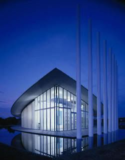
All of these facilities are much, much, much more than just boathouses. Ironically, the one I know the least about is the OU Boathouse, which is the one with red poles, obviously. I can say that obviously it will be the home of the most-major collegiate program coming to the banks of the Oklahoma River.

Other collegiate programs are UCO and OCU that are both going to have collegiate NCAA rowing programs, all three of which will be based here. The OCU Boathouse, which is the two-story one (and the largest) with blue poles, is 34,000 sf total (about twice the size of all of the others, including the 16,000 sf Chesapeake Boathouse) and comes with the most innovative rowing features ever built. It will be of use to the OCU crew and Olympic athletes training in OKC. Both the OU and OCU projects are expected to be finished within 60-90 days of eachother in Fall 2010.

The UCO Boathouse will be the second largest facility, at 27,000 sf, and it will include art gallery space, a UCO Jazz Lab location, and the UCO rowing team's high-performance training facilities..not sure the exact projected completion date for UCO, but I know it is supposed to begin soon after OU, and I assume its construction phase will outlast OU's since it is a much larger facility. When these projects are finished there is another impressive slate of huge national and international events planned for the river that will put these facilities, and OKC's bolstered river amenities, to the ultimate test.

To sum up what's in play, I like what Glenn Merry, the CEO of USRowing, said upon visiting OKC for the Devon Boathouse (OCU) groundbreaking.

"I think it’s beyond unique,” Merry said.

In some venues back East, rowing is thought of as an elite Ivy League sport, he said. Oklahoma City, however, has been able to attract 30,000 to 40,000 people from "all aspects of life” to its rowing regattas.

"I think Oklahoma City has a larger vision than anyone else,” Merry said. "It’s pretty exciting what’s going on here.”'


I agree, it definitely does seem to be a larger vision than anyone else, taking an elite Ivy League sport and sticking it in the middle of Oklahoma as a spectator phenomena that is unique. Exists nowhere else. Shifting gears, you know what could make this even better? Reminding people that they are A, in a city; and B, in Oklahoma City. That means speerheading urban redevelopment projects (Core to Shore), and the completion of a new state-of-the-art museum across I-35 (the American Indian Cultural Center).

Capitalizing on all of the momentum in downtown and along the Oklahoma River is the daring initiative to redevelop the 600 or so acres in between the current I-40 route and the Oklahoma River. By reallocating I-40, at a whopping cost exceeding $600 million, there will be much more room to move around and develop south of the downtown core. To push for the "right development" the city is prepared to use Maps III to invest $100 million in a new downtown central park modeled after Chicago's Millennium Park, a new $250-300 million convention center, and a "landmark boulevard" to replace the current I-40 that would be something like an OKC version of the Champs d'Elysees in Paris. The result--an expected windfall of thousands upon thousands of residential units, hundreds of new shops and restaurants, and additional office towers. In essence..a new downtown. The mixed-use development doesn't stop there.


In fact the first mixed-used project to be proposed south of I-40 is Grant Humphreys' Downtown Airpark redevelopment, which is actually just outside the C2S impact zone. Located on the south bank of the Oklahoma River, at the Western Avenue bridge, this mixed-use project includes several mid-rise buildings that frame waterfront amenities like open greenbelt, an inlet lined with boat docks, a boardwalk, river trails, and a famous lit-up ferris wheel. Behind the mid-rises is a mixed-use village of shops, apartments, and townhomes. To me, this is a perfect first example of how a large-scale development can set the tone for future development, with its own river amenities, a unique aquatically-oriented urban community, and a site layout that comes right up to the river and frames it with as many different uses as possible--you've got recreation, shopping, dining, and living all within feet of the river.

Another project that makes really cool use of its site on the river is the American Indian Cultural Center. The 300 acre site donated by the City of OKC will have a state-of-the-art Smithsonian-affiliated museum, several prominent promontories that will have excellent views of the AICC, the river, and the rest of OKC, a 200-room tribal resort hotel on the riverfront with a conference center attached, and a 150-room "full service motor hotel" (I guess kind of like a Holliday Inn?). The meticulously landscaped grounds will include 3 separate Oklahoma ecosystems..prairie, woodlands, and wetlands.


These guys have (unfortunately) ran into multiple funding snags (their private fundraising must really suck, and what about all of those windfall profits the Indians are making from their beautiful shiny new casinos?) but it looks like they'll receive some State funding, and maybe even some Maps III funding if they can get their hands on it..and they'll be completing this project (originally scheduled to open in 2006) eventually. It's probably a good news that as I type, they're finally beginning to plant grass along all sides of the crescent-shaped mound that is the centerpiece of the project. Despite their incompetence during the fundraising and construction phase, it will be a very cool attraction to have come to OKC. This will really add a lot of diversity along the river and bookend a huge list of new attractions, and maybe even landmarks, along the Oklahoma River.

As all of these exciting things culminate, and OKC undoubtedly becomes a "Big League City," one must ask..where does this leave us? I think that there are some obvious question marks that are left open when it comes to the river and all of these plans. The first one, is how is someone supposed to get from one stop to another? I seriously doubt that the Devon Discovery watertaxis are going to work in getting someone from a restaurant at the airpark redevelopment site, down to Stockyards City, or over to the AICC, and then back to see a regatta at Boathouse Row. There is going to be a reevaluation of the street grid in that area. First, there will need to be a street that links the AICC, goes over I-35, and links potential Maps III Boathouse-related stuff on the south bank of the river. Then the bridges needed by reevaluted. Something that is more iconic is needed, even if it's just installing LED lights such as with the Byers Avenue bridge. Perhaps a streetcar system might be a good investment just for the river, or include it in a city-wide light rail system that goes outside of just downtown, but these are ideas for further down the road.

Then there is the obvious. The river is becoming naturally hazardous. It's not a natural river, so it isn't able to drain off pollution such as animal fecal material. This makes it a bad, bad, bad idea to have swimmers in the river, such as with Triathlon events (that made national news..eeek). Maybe the whole treeless river lined with granite and completely unnatural thing isn't working out after all. Either this river can never be used for Triathlon events, or someone will need to plant some trees, swap the granite for some tallgrass, catgrass, mossy stuff, weeds, and whatever else you would normally find along a natural riverbed.

So much progress has been made out of such an unlikely venture. OKC isn't much different than it was 10 years ago even though its economy is much better, but in the next 10 years, OKC might come out of this a much more cosmopolitan and prominent "Big League City" that people all over respect. This has afforded civic leaders an opportunity to develop a world-class city that is similar, but different than the opportunity that each preceding generation has had. Everything has led up to this. The first generation built and designed a fantastic city, that was basically brilliant. The second generation had bold plans to add a futuristic touch to the center city and ended up screwing everything up. Those wounds have healed after a lot of hard work in the last 15 years, and it's time to forge on! We should head history's lessons, but strive to be unique at the same time. I think that this is what we've done. As long as the LOCAL economy doesn't tank on us, I think OKC is jet-set to become a world-class city. All of the potential is here, that is for sure. At the least, if someone can consider Denver, St. Louis, or Indianapolis world-class, they will be able to consider the OKC of the future just the same.


Critical thoughts on COTPA's leadership of the Maps III transit initiative


Vs.


Everywhere I turn on the web, from Steve's blog, Blair Humphrey's blog, OkMet, OKC Talk, and everywhere else, I can't help but notice the consensus that a downtown transit system has been replaced by anything and everything else. For the last two years the mayor has been campaigning for light rail, using the issue as the centerpiece of his civic initiative to make OKC more pedestrian-friendly, even lamenting the issue of streets built for cars, not people. I always thought he was spot on, and many of us had thought he had been turned into a rail advocate.

Undoubtedly I think we were wrong.. it seems that Mayor Mick is a pragmatic politician after all. When the public current seemed to favor light rail above any other potential initiative, we saw the mayor talk about how badly OKC needs something different for its transit system. Now that the business community has gotten serious about the convention center and the river, there's a lot of suspicion that transit has been relegated to the bottom of the food chain.

In many ways, it has been. Mayor Mick and the Chamber folks didn't necessarily put together a list that pushed transit towards the bottom of priorities. Instead what they did, whether as an intentional slight or not, was put COTPA in charge of the initiative. This means that the same people who have been running every transit proposal into the ground for the last two decades are now inflicting their usual incompetence on another great idea.

Two decades ago when city leaders embarked to put together Maps I, Ron Norrick initially wanted the proposition to include a downtown fixed transit system (I'm not sure if it was streetcar or light rail, but I think light rail, if I remember right). I was probably in 1st grade in Galveston, TX back when Maps I was passed, but from what I've heard and read, it was a combination of bad project management and former Congressman Ernest Istook's hidden agenda that killed the idea of light rail in OKC during the 1990s. Just think..if someone had been a better project manager, or had Ernest Istook not been taking money from the Oklahoma highway lobby..OKC would have had light rail before many of the cities that are now light years ahead of us. Like Dallas. They've ran the city bus system into the ground. If you disagree, try to make sense of their website for routes and schedules, etc. They've wreaked havoc on the downtown streetscape with their unsightly public garages that have ruined the look and feel of much of downtown. Essentially, where there is failure in downtown OKC, COTPA has usually been right behind it.

Many other blogs have been reporting that COTPA's transit initiative has been underwhelming city leaders, at best. This at the same time as fabulous presentations on Mike Knopp's proposal for more Oklahoma River investment, the business community wholly behind the convention center proposal, the Bricktown community behind an extension of the canal, and the bio community behind the idea of a new bio research facility in the medical district. Everyone has proved without a doubt that their project is worthy of Maps III funding except COTPA. They've officially ran out of ideas, ran out of steam, ran the downtown streetcar intitiative into the ground, and now they need to be ran out of town.

COTPA needs to be replaced with something else. A temporary solution is for the City to recognize Jeff Bezdek's Modern Transit Project group as the leadership behind the transit issue. It seems like a no-brainer. This group has passion, is personally invested in the issue (as downtown residents), they have new blood and new ideas, and they have done an excellent job of marketing what they are all about. Nobody can say they have no idea what they're proposing. They've clearly defined their project as STREETCAR, not LIGHT RAIL. They've done research and proposed a cost, they've proposed a route, and they've also done a brilliant job of integrating the streetcar project with other sustainability goals, by proposing that locally-harvested wind power be used to power the system. They've defined environmental benefits, sustainable benefits, health benefits, transit benefits, and urban benefits. They've also defined benefits from a regional competition standpoint, by comparing OKC to every other NBA city. Almost all of which have fixed rail systems.

If this private group were given the chance to make presentations alongside Knopp and the convention center boosters, they would knock the socks off of attendees, and we would see a downtown streetcar system be a virtual guarantee as a part of Maps III. If we continue to let the "know-how" at COTPA dictate the transit initiative, we will end up with no fixed transit system, and merely some token bus upgrades. It is better in the short-term, and the long-term, if slowly COTPA's responsibilities get moved over to other more captivating entities and COTPA is phased out.

Wednesday, June 3, 2009

"Staycation" Pt. 1..the Southside Sears

With the economy tanking (supposedly), I heard a rumor from a distant cousin that many of us are opting for a summer "staycation." A "staycation" is doing something cool and staying home, as opposed to doing the classy thing and spending money to travel somewhere else to do something cool. The really cool thing is that a "staycation" can include things that you didn't even realize qualified as a "staycation." For instance.. a vacation would be going to visit this really cool rocky sea shore in the picture..BUT a "staycation" is even cooler; instead of spending thousands of dollars to travel and all that, you can just look at this picture with computer icons on it and close your eyes and pretend to be there! Now isn't that way cooler?

Another example: I went to the Warren Theatre off I-35 in Moore to see Star Trek for the 14th time (hey, I hadn't seen it yet in Oklahoma!) and much to my regurgitation, since I'd been gone they added this cheesy "Voice of the Theatre" character who says corny things and reminds you that the economy has tanked before telling you you're on a really cool "staycation." According to the "staycationers," you can have way more fun staying home as opposed to snorkeling in Bora Bora.

So I realize, a "staycation" really can include practically anything, especially something mundane like going to your neighborhod cinema. So I had an idea to do a series of incredibly super fricken awesome "staycations." To pull this off, I actually went on these aforementioned "staycations." The first one I went on was a trip to the land of SW 44th and Western.. the Southside Sears!!


First of all, I would just like to mention what a magical experience coming to this Sears in particular has been. What else could you call the forces that have kept this Sears in business for 50 years? It will never close its doors, no matter what. In fact, the only thing more depressing than the parking lot of this Sears is probably Crossroads Mall, another wonderful Southside landmark. I counted 12 cars in the parking lot when I came..7 of which were dark green 1994 Buick Regals with bumper stickers about their grandchildren.

I decided I needed an excuse to be in there. I would pretend to be looking for their Ralph Lauren section, since I was wearing a Ralph Lauren shirt that day (they didn't have any Ralph Lauren, but the guy told me they had something called "American Living" that was "just like" Ralph Lauren..right, cuz anyone can make polo shirts and stuff to golf in). I walked in the front door and saw that they had a greeter, who probably drove one of those dark green Buick Regals. Turns out grandpa was a light sleeper, because he was woken up by the sliding door. I said to him, "Not much of a crowd you guys have got here!" Grandpa replied, "What did you expect when you're late! Our normal business hours should be 5 am to 9 am! Humbug!" I had officially been greeted to the Southside Sears.

I walked around a little, trying to find a section that was targeted toward the 20-25 year old age group. I found it, but I realized it wasn't really targeted toward my age group..but more targeted towards elderly grandparents buying something for my age group. I found a few racks of argyle pattern shirts, Wrangler jeans, tube socks, and snowflake pattern sweaters (in the summer). It dawned on me that I was probably standing in the very spot that all of the awful Christmas presents my grandparents always got me were purchased. It was a very special feeling.

I thought of my grandparents, and suddenly realized my dad was also getting to be that age. As a retired police sgt from the Lawton Police Force (probably the only police dept in the state that actually has crime), he definitely looks his age, plus twenty years. I decided it might be funny to get him a pair of tube socks from the Southside Sears. After picking a pair that was a weird bright-dark shade of green (so that it would match none of his shoes or pants), I went to the checkout station..where I waited for 5 minutes for an elderly woman to come ring me up. She told me I was buying a lovely pair of tube socks, and that I reminded her of her grandson. His name is Jacob..and he goes to Oklahoma Baptist University. She offered me a piece of hard candy. Believe it or not, Werther's Original is some prrrrretty good caramel.

So now we've experienced something magical, met someone interesting, learned something about family history, and tasted some delicious local cuisine of this land called Southside Sears. What more could you want in a "staycation" I thought, as I walked out to my rebelliously cool yellow SUV and drove off before I could feel any weirder.

Tuesday, June 2, 2009

120 degrees and 400% humidity

Well it's pretty much a shock to my system to be back in Oklahoma, especially during the summer, especially after recovering from Calgary's brutal winter. God is probably looking down on me laughing his ass off right now. I envy whoever is from Calgary that goes to school at OU (they're probably not studying architecture) because they get to spend the winter in Norman, and the summer in Calgary. That's a good balance. This however, is a balance..but a really, really bad one.

Now that I am 100% back in town and all set up, hopefully it will be a lot easier for me to update this blog, be more active both in kind and online when it comes to OKC's urban transformation, and all of that good stuff..before I go back for my 4th year of arch school. In the past, whenever I wasn't on the U of C campus I had to use my pda phone to stay connected to the Internet and blogs..but now it won't feel like I'm writing the World's Longest Text Message each time I comment on a blog, write a blog entry, etc. I already feel liberated from my mouse-sized qwerty keypad!

There are so many issues to tackle. There are so many improvements to take stock of and celebrate. And there is so much planning and striving that remains to be done that no time can be wasted.

I don't really know what to tag this blog entry under, so I'll give it a tag I have no idea about..anecdotal whimsy. It makes perfect sense..I have no idea what anecdotal whimsy is, and I have no idea what to tag this entry..so it's a match made in Heaven.

Monday, April 13, 2009

Cityshot XII


Progress at Sage Gourmet Market -- this will be a GREAT addition to Deep Deuce

Thursday, April 9, 2009

OSU Student-in-Chief

At age 27, Nathan Bates is becoming the next mayor of Stillwater, winning the close election by a fitting 27 votes..surely a huge upset in the realm of municipal politics. He has still not graduated college, due in part to his intermittent service in the U.S. Navy for several years.

"Many people thought the incumbent could not be defeated out here and a student running for office was a joke," Bates said. "As unexpected as this has turned out to be, it is the single greatest honor I've had in my life, and I will serve to the best of my ability."

Friends of mine in Stillwater thought him running for mayor was a joke, even, because he didn't have the best platform and had no experience. But apparently you don't need either in order to be mayor of a town dominated by a large state university. The latest statistics show 48,000 people living in Stillwater (a huge increase over 39,000 since 2000), and there are about 24,000 students at OSU in Stillwater. It becomes very obvious how a student could win mayor if just enough people stop by the polls to vote him in.

In May 2008, Muskogee elected John Tyler Hammons, a student at NSU in Tahlequah who is now 20 years old, as the youngest mayor in the country. Perhaps this is just the beginning of a growing trend across the Sooner State..one that has not yet played out. The jury is still out whether these college students would make good mayors, so the fate of future college students' mayoral campaigns (what an ironic phrase?) rests on the performance of this first batch.

Monday, April 6, 2009

Out of the woods yet?

I think it's time for some critical evaluations of our hometown. Take a look at these population growth percentages by decade.

1890 4,151
—
1900 10,037
141.8%
1910 64,205
539.7%
1920 91,295
42.2%
1930 185,389
103.1%
1940 204,424
10.3%
1950 243,504
19.1%
1960 321,599
32.1%
1970 368,164
14.5%
1980 404,014
9.7%
1990 438,922
8.6%
2000 506,132
15.3%
Est. 2007 547,274
8.1%
Ignoring the city's founding, you can see where the initial rapid growth of OKC eventually leveled off after 1940 but picked up speed again. This time not because more free land was opened up for settlement and the opportunities to start new lives; but because the oil business had become more entrenched in OKC. Oil-reliant businesses boomed, too. Banks were established that specialized in financing oil speculation (like the Penn Square National Bank) and manufacturers of oil field equipment boomed. Between 1940 and 1950, OKC grew nearly 20%; Between 1950 and 1960, 32%--can you say Austin, TX?

Then the 1980s came and hard times fell upon Oklahoma. Growth slowed to 8.6% during the 80s and picked back up slightly to 15% for the 90s, and it will barely peek above 10% for the 2000s unless net migration suddenly picks way up. Looking at this population growth, can we honestly say that right NOW in 2008, OKC's economy is back to being out of the recession?

Sure, one can point to all of the great rankings. Most Recession Proof City, in a nutshell. That speaks wonders as a testiment to a city's sound fiscal policies. Mayor Mick should be proud (and is). But on closer examination, can't one conclude that this current recession is leveraged on the collapse of high-finance? Something Oklahoma isn't really effected by. Some of the places most affected by this recession include California, Nevada, Arizona, Florida, and Georgia--some of the states that benefited the most from economic expansion ever since the oil bust. Their economies grew so much that money was being thrown around freely and carelessly, eventually causing chaos in the financial system. In OKC money was never being thrown around freely and carelessly (whether you agree with that or not, everyone agrees there was never a housing bubble here). We were not a part of the high, and we are not a part of the low. But presuming that the rest of the nation's economy recovers soon--where does that leave Oklahoma?

I see two scenarios:
  • The first is one of prosperity, because once the credit markets thaw there will be a lot of money to invest in real estate. Developers will be looking for markets that are deemed very safe, which would be OKC.
  • The second one is one of average plight. OKC goes back to being nothing special, as companies will consider it safe to invest or even "over-invest" in glamorous locations with the best demographics.
The thing that hurts OKC the most is the simple fact: People are not flocking there, and have not for a very long time. There will always be the unfair characterization that the culture is not known for opening up to diversity and the fair characterization that education attainment is lacking in Oklahoma due to the brain drain that sends our college graduates to Texas and New York, among other places.