The view of Downtown Little Rock from the 2nd floor of the Clinton Library
Friday, July 31, 2009
Wednesday, July 29, 2009
Medical District progress
I was driving around with my camera taking pictures of mixed-use developments under progress across the metro, which is a dauntingly huge task that I can only hope to have finished by the time I leave to go back up to Calgary, but as I was coming the metro, I came across the Medical District and realized that these major developments in this inner city district deserve some attention. Tonight I will be posting these, hot off my phone camera, because it is so much easier to take pictures of development in a small district, than to track major mixed-use development in a metro as sprawled as OKC. I haven't even gotten a fifth of those pics yet, but in the meantime, feast your eyes on these.
I think it suffices well enough to say that the Medical District is coming along very well. I wish I could have taken a few pictures of the towers and hospital complexes already in this area, including some really amazing contemporary architecture I just kept driving past simply because it's already been completed for at least 5 years (the OU Physician's Bldg, namely). And starting closest to I-235:
 Oklahoma Blood Institute HQ on NE 8th Street, between Lincoln and I-235, 3 story frame is going up. No renderings online, but I believe it will just be a plain white 3-story office bldg.
 This is something on NE 10th, across Phillips from the OU Cancer Institute..and I have no idea what it is, but the rendering shows a fairly low-rise structure.

 OU College of Allied Health on Stonewall Avenue, nearly complete. I think it turned out beautifully.

 The OU Cancer Research Institute on NE 10th Street, the structure went up really fast, but the annex is still yet to go, and then comes the tedious stuff.

 Dean McGee Eye Institute on Lincoln Blvd, pretty close to completion.

 OU Children's Hospital on NE 13th Street, as you can see nearly finished, but the lobby and parking lot are still to be finished.


 OMRF Research Tower on NE 15th, broken ground, sign in the ground on NE 13th.
I think it's really impressive all of the construction going on here in the Medical District, when you consider how it mostly goes unnoticed and without any praise. We're all far too busy bickering and making accusations over MAPS 3 and Core to Shore to take notice of what's going on northeast of the core. I think that's detrimental to our city's direction, though. We're really lucky to have this burgeoning medical district located so close to downtown, instead of miles away like most cities that have similar medical districts, or bigger (like Houston). The truth is that not very many cities have entire medical districts complete with some of the most advanced hospitals in the world, and considering that this is what is being built without anyone taking notice here in OKC, is just truly incredible to me.
Oh and I just realized I left out the Medical District Embassy Suites (an 8-story full-service hotel) being built at Phillips and 8th. I didn't notice much work being done on it from 10th or it would have caught my eye, but I do recall last year that the site was surrounded by a construction fence.

I think it suffices well enough to say that the Medical District is coming along very well. I wish I could have taken a few pictures of the towers and hospital complexes already in this area, including some really amazing contemporary architecture I just kept driving past simply because it's already been completed for at least 5 years (the OU Physician's Bldg, namely). And starting closest to I-235:
 Oklahoma Blood Institute HQ on NE 8th Street, between Lincoln and I-235, 3 story frame is going up. No renderings online, but I believe it will just be a plain white 3-story office bldg.
 This is something on NE 10th, across Phillips from the OU Cancer Institute..and I have no idea what it is, but the rendering shows a fairly low-rise structure.
 OU College of Allied Health on Stonewall Avenue, nearly complete. I think it turned out beautifully.
 The OU Cancer Research Institute on NE 10th Street, the structure went up really fast, but the annex is still yet to go, and then comes the tedious stuff.
 Dean McGee Eye Institute on Lincoln Blvd, pretty close to completion.
 OU Children's Hospital on NE 13th Street, as you can see nearly finished, but the lobby and parking lot are still to be finished.
 OMRF Research Tower on NE 15th, broken ground, sign in the ground on NE 13th.
I think it's really impressive all of the construction going on here in the Medical District, when you consider how it mostly goes unnoticed and without any praise. We're all far too busy bickering and making accusations over MAPS 3 and Core to Shore to take notice of what's going on northeast of the core. I think that's detrimental to our city's direction, though. We're really lucky to have this burgeoning medical district located so close to downtown, instead of miles away like most cities that have similar medical districts, or bigger (like Houston). The truth is that not very many cities have entire medical districts complete with some of the most advanced hospitals in the world, and considering that this is what is being built without anyone taking notice here in OKC, is just truly incredible to me.
Oh and I just realized I left out the Medical District Embassy Suites (an 8-story full-service hotel) being built at Phillips and 8th. I didn't notice much work being done on it from 10th or it would have caught my eye, but I do recall last year that the site was surrounded by a construction fence.
Malls, malls, malls.."galore"
I was doing a post on Crossroads Mall, which most people know I hate, and I was thinking of a lot of different things. I was thinking of how evil indoor shopping malls are. The advent of Crossroads Mall in the 1970s as the 8th largest shopping mall in the U.S. at the time was the death of the inner south side. Another thought was, God it will be great when Crossroads bites the dust, as it'll free up some retail demand for the inner south side. You see growth all over the metro, everywhere, except the inner south side. You especially see it in NW OKC and the Cleveland County area, however in order for the "urban revival" fad to spread to the inner south side, it will require some kind of impetus to get the ball rolling in a positive way.
I think the good thing about new urbanism is that it takes into account the full lifespan of a mall, including its decline. With these indoor mega shopping malls, once they go into decline, it's difficult to find any useful purpose for them to serve. Shepherd Mall got converted into an office building, but that only works if you have a large office tenant lined up and ready to go, such as AOL in the case of Shepherd Mall. Northpark Mall just shifted its focus to older, upscale demographics and filled its stores with high-end local boutiques, which is kind of cool for a mall, but they would have a better location lining a pedestrian-friendly avenue. Penn Square has managed to stay on top of the game by being close to OKC's wealthiest areas. Sooner Fashion Mall has stayed pretty nice by being the only place to shop in the midst of rapidly-growing Cleveland County.
Crossroads Mall has gone the way of the dodo by being close to OKC's worst areas, not keeping its best long-time tenants, and the sheer inability and unfeasability of converting it to any other meaningful use. There is no way to make good use of Crossroads Mall. The mall is too horribly designed, the site plan kills the idea of any other use, and it's literally located between a ghetto and a towering landfill. AND the site connects to nothing except freeway onramps at I-240 and I-35, so the name Crossroads Mall itself is even somewhat deceiving. Whoever's idea it was to build this mall needs to be shipped and Mexico where hopefully they won't ever again have any say in American city planning.
This brings me to Quail Springs Mall, which is obviously a vibrant mall today, but in the future..it will be the next Crossroads Mall. Things it has going for it.. one: it, like Sooner Fashion Mall, is surrounded by an extremely high-growth area of the metro that will economically buoy it for a long time; two: the site does actually connect to much more than just freeway onramps, and Memorial Road itself is lined with so many office complexes, developments, and so forth, that it's hard to imagine this corridor will give way to suburban blight. Things is has going against it.. one: the Quail Springs area will likely always be a pretty nice area, but that doesn't mean that the main focus area for retail may not shift to OK 74 or some other road if Memorial Road isn't any longer a short 15 minute drive for these people; two: Quail Springs Mall will soon be facing competition from more exciting new urbanist developments, one of which will be directly adjacent to the mall's north side, where Dillard's is. The Quail Springs area will also be facing increasing competition from Edmond, which will probably become the new urbanist mecca for Central Oklahoma. It's hard to say that Quail Springs Mall will stand up to more exciting developments along the far north edge of the metro for very long.
The moral of this story: When you plan a development, consider its full lifespan (its vitality, its middle-aged period, its decline, and its reuse). Indoor shopping malls are always a bad idea.
Friday, July 24, 2009
A Crossroads update
 The mall that just won't die. That is Crossroads Mall. It's like a huge flying cockroach that you keep trying to kill by stepping on it, but just won't die because its damn carcass is too squish-proof. Crossroads Mall has lost every long-time anchor: Ward's, Foley/Macy's, J.C. Penney's, and Dillard's. It even lost Steve & Barry's Crappy College XXL Megastore.
Thank goodness though for that southside ingenuity, that rugged hard-headedness that won't take defeat as the last word..instead of having a completely blank sign fronting I-35, they've filled up the spots maintaining the appearance of a mall, somewhat. It announces to a hundred thousand commuters a day on I-35 that its major anchors are Bath&Body Works, Waldenbooks, and Chick fil-A, and that there is an AMC movie theater on I-240 in front of the mall. That's what I call "maintaining appearances" through hard times.
And thank goodness that ODOT did not go through with an overhaul of the I-35/I-240 intersection just because it would have blocked off the main I-240 exit to this oasis of cosmopolitan shopping that is Crossroads Mall. Nevermind that there are deadly car accidents every day here, and the constant traffic tangle during the day, because if Crossroads Mall had died, the southside would have been without its crown jewel, Crossroads Mall.
Thursday, July 23, 2009
Top 40 largest cities in 1900
This here trivia game is pretty cool, and it's easy to play. Just click Ready and enter in the names of cities. You have 6 minutes to guess as many of the Top 40 largest cities in 1900. It's a really cool interactive way to learn our nation's urban history.
I got 35. If anyone beats me, I'd like to hear about it!
I got 35. If anyone beats me, I'd like to hear about it!
Monday, July 20, 2009
A canal extension that works
Well, it's not really a canal extension..but rather a Riverwalk extension. San Antonio's recently-finished 1 and 1/3rd-mile extension of the Riverwalk, extends north out of Downtown San Antonio and cuts through a dense area lined with some mixed-use development and the San Antonio Museum of Art. The entire new extension of the Riverwalk is a work of art though, in how underpasses that posed a risk as a potential eyesore were brightened up with public art. A few highlights are.. adorning the Lexington Street underpass are shimmering tiles that catch the light and sort of flitter, colored metal panels under another underpass, a new landscaped landing abutting the San Antonio Museum of Art, and under the I-35 bridge are hanging fish to take away the marr of a highway bridge, and a "grotto" theme at the Camden/Newell intersection. The entire 1.33 mile extension is heavily landscaped, which goes without saying. You can learn a lot more about the Museum Reach segment by checking out this interactive map on the San Antonio Express-News' website.
Here are some pictures taken by popnfresh on SkyscraperCity:
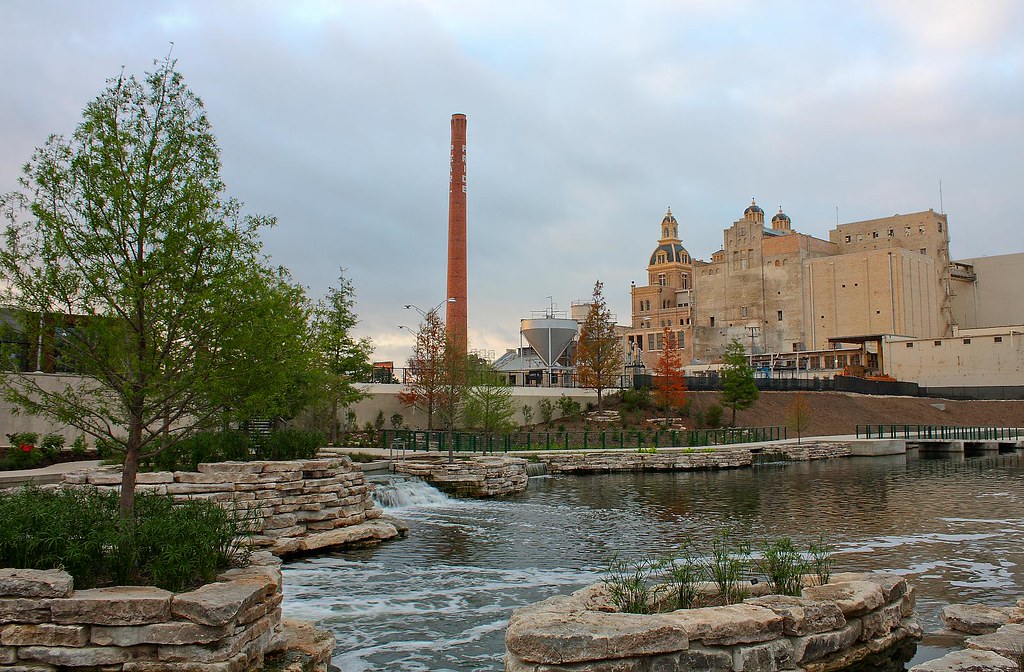
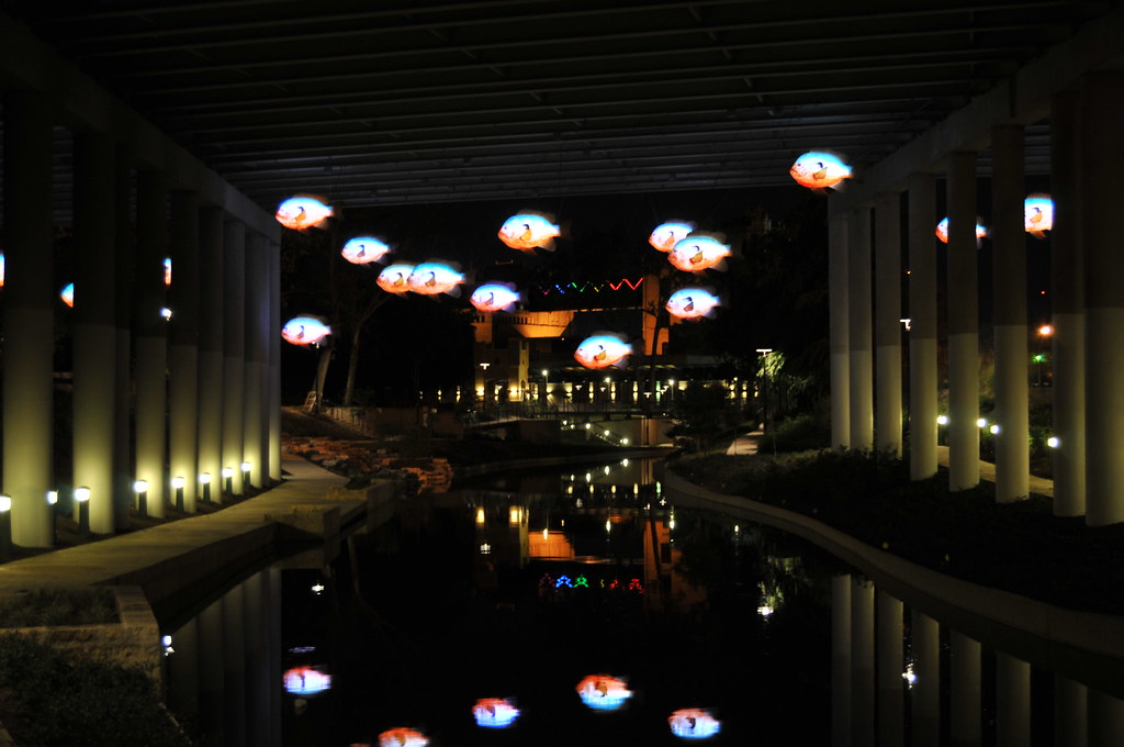
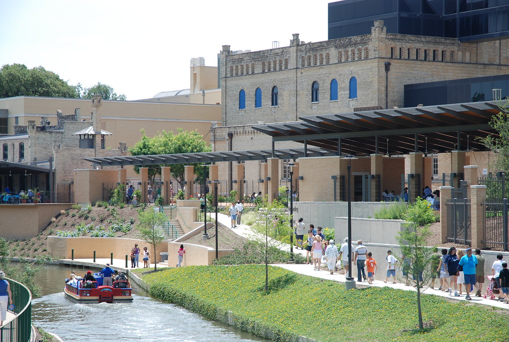
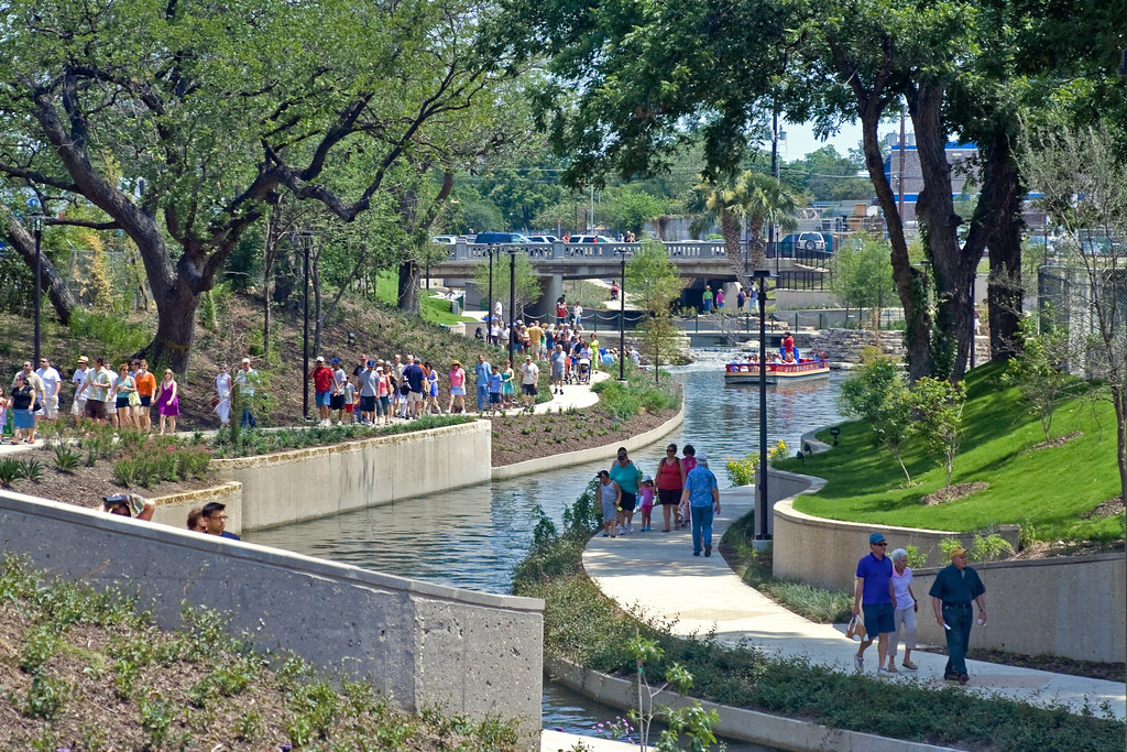

Why was this project a success: The reason that the Museum Reach urban segment of the Riverwalk is such a success is that the right-of-way already existed. The urban fabric already developed around the San Antonio River, and the City of San Antonio is just coming in and giving major aesthetic upgrades to an existing riverfront. The design is innovative and does two things: it incorporates existing "landmarks" along the path, such as the art museum and the Pearl Brewery, which has become a large mixed-use redevelopment project, AND the second reason is that it is innovative in covering up eyesores, such as bridges, and brightening up these dull spaces.
Why copying this would fail in OKC: OKC does not have an existing river that flows through the heart of downtown. There is no neighborhood or even single city block that matured framing a water right of way. The Bricktown Canal is an absolutely brilliant conversion of an alley way into a canal. Where dumpsters, vagrants, and utility lines once were is now an area lined with upscale restaurants, clubs, and the Bricktown haunted house. This is why future planning involving the Bricktown Canal MUST be taken from an "opposite-of-San Antonio" perspective in order to be successful. We have to look for existing right-of-ways that we can easily adapt to become a thin sliver of waterway, and truthfully it isn't a good idea to delve into Core to Shore with the Canal and expect to create a space that matures framing an urban canal. It won't work.
Here are some pictures taken by popnfresh on SkyscraperCity:
Why was this project a success: The reason that the Museum Reach urban segment of the Riverwalk is such a success is that the right-of-way already existed. The urban fabric already developed around the San Antonio River, and the City of San Antonio is just coming in and giving major aesthetic upgrades to an existing riverfront. The design is innovative and does two things: it incorporates existing "landmarks" along the path, such as the art museum and the Pearl Brewery, which has become a large mixed-use redevelopment project, AND the second reason is that it is innovative in covering up eyesores, such as bridges, and brightening up these dull spaces.
Why copying this would fail in OKC: OKC does not have an existing river that flows through the heart of downtown. There is no neighborhood or even single city block that matured framing a water right of way. The Bricktown Canal is an absolutely brilliant conversion of an alley way into a canal. Where dumpsters, vagrants, and utility lines once were is now an area lined with upscale restaurants, clubs, and the Bricktown haunted house. This is why future planning involving the Bricktown Canal MUST be taken from an "opposite-of-San Antonio" perspective in order to be successful. We have to look for existing right-of-ways that we can easily adapt to become a thin sliver of waterway, and truthfully it isn't a good idea to delve into Core to Shore with the Canal and expect to create a space that matures framing an urban canal. It won't work.

Saturday, July 18, 2009
25+ comments over at Steve's blog
As many of you know, there are a few other blogs I regularly check..including much more reputable ones than mine. While I'm not nearly as idiotic as some people tend to think I am (lol), I would have to say there are more educated opinions than those of an architecture student who has only been able to drink legally for a few months. That's why it's an honor to see much more respectable folks such as Steve Lackmeyer of the Daily Oklahoman mention me on his blog, and most notably, my recent push against Core to Shore. His post where he linked my C2S alternative impelled 25+ comments..which I think is awesome..and I can see where it pays to go with eye-catching, attention-grabbing headlines like "Core to Shore sucks."
I don't really believe Core to Shore sucks, I just believe it is dangerously flawed. I don't know how someone can just go forward thinking this is the best thing since sliced cheese with all of the new considerations that have come up from reputable sources--sources who aren't against Core to Shore because they hate downtown, but because they love downtown and want to see what's really best for it. That's what's so surprising about the direction that the debate over C2S has turned, that the opposition isn't coming from the southside folks who oppose "MAPS for Millionaires" at all costs--but from the biggest fans of downtown. Consider that.
Even though it's not my blog, I thought I might address a few of the comments that were illicited by Steve's post. This is what I call a fun Saturday night..
That said, I just wanted to point out that it wasn't city council leaders that created the plan we deem as pedestrian-God-awful. It was actually an ensemble of local architects, Hans Butzer and Anthony McDermid (great guys..and I had Butzer for a class even), City Planner Russel Claus, and Sara MacLennon. MacLennon was the leader of a planning firm brought in (and paid about $100,000) to help design C2S. The firm was not even from within 1,000 miles of Oklahoma..I believe they had some planners from Denver and Omaha that I met at the public meetings in the Cox Convention Center. I have to question why people with no clue about Oklahoma City were brought in as the professionals behind the C2S project, when there are plenty of planning firms here in Oklahoma. Of course, there is a separate C2S Steering Committee, which does include city council, as well as dozens of community leaders.
Dennis, I don't see the problem in having a bungalow neighborhod adjacent to I-35/I-40. The reality is that there is still a wide right-of-way separating the neighborhood from the freeway interchange that the intrusion is minimal, and the reality is that in cities all across America that are neighborhoods that back up to freeways. Crown Heights backs up to I-235 (and what will return to being a construction zone, at that) and the separation would be equal. Jefferson Park is right up against I-235. There are upscale neighborhoods off of I-35 in Edmond, and freeways all over the metro pass through close proximity to residential neighborhoods. A dense single-family unit neighborhood is the best use for that land, or else it will just go as dead space in the middle of the city.
The main reason I moved the convention center wasn't because it wasn't close enough to Bricktown, but because it was too close to the existing Coc Center and the Ford Center, and the park. I feel like it's imperitive to break up these super-block structures or else we will be stuck with a huge vacuum of 24/7 activity in the middle of C2S. In order for the park impact to be fully realized on development, the park edge needs to be lined with as much development as possible, and as few super-block structures as possible. It happens to be a huge benefit that the alternative site is across the street from Bricktown. As for the boulevard in my alternative being huge and inhibiting access, I would say that's wrong, and that's actually one of the main points to my alternative. My alternative boulevard is mirrored after Commonwealth Avenue in Boston, and is the complete opposite of the Okie Champs Elysees that the C2S planners have envisioned.
I don't really believe Core to Shore sucks, I just believe it is dangerously flawed. I don't know how someone can just go forward thinking this is the best thing since sliced cheese with all of the new considerations that have come up from reputable sources--sources who aren't against Core to Shore because they hate downtown, but because they love downtown and want to see what's really best for it. That's what's so surprising about the direction that the debate over C2S has turned, that the opposition isn't coming from the southside folks who oppose "MAPS for Millionaires" at all costs--but from the biggest fans of downtown. Consider that.
Even though it's not my blog, I thought I might address a few of the comments that were illicited by Steve's post. This is what I call a fun Saturday night..
"Our city council leaders seem very ignorant concerning the principles of pedestrian-friendliness. I’m worried this is going to be a disaster…" - Kris BryantKris, the city council has been surprisingly silent on the matter of Core to Shore. While we have to assume that they will support MAPS 3, obviously, I almost feel like the city council isn't even very involved in the process. Ultimately they will be the deciders, but I don't know how many original thoughts they have. I can't judge for myself, because there is no known, 100% reliable way to determine the original thoughts of a largely silent group of people, with the exception of the Supreme Couty.
That said, I just wanted to point out that it wasn't city council leaders that created the plan we deem as pedestrian-God-awful. It was actually an ensemble of local architects, Hans Butzer and Anthony McDermid (great guys..and I had Butzer for a class even), City Planner Russel Claus, and Sara MacLennon. MacLennon was the leader of a planning firm brought in (and paid about $100,000) to help design C2S. The firm was not even from within 1,000 miles of Oklahoma..I believe they had some planners from Denver and Omaha that I met at the public meetings in the Cox Convention Center. I have to question why people with no clue about Oklahoma City were brought in as the professionals behind the C2S project, when there are plenty of planning firms here in Oklahoma. Of course, there is a separate C2S Steering Committee, which does include city council, as well as dozens of community leaders.
The main reason I moved the convention center wasn't because it wasn't close enough to Bricktown, but because it was too close to the existing Coc Center and the Ford Center, and the park. I feel like it's imperitive to break up these super-block structures or else we will be stuck with a huge vacuum of 24/7 activity in the middle of C2S. In order for the park impact to be fully realized on development, the park edge needs to be lined with as much development as possible, and as few super-block structures as possible. It happens to be a huge benefit that the alternative site is across the street from Bricktown. As for the boulevard in my alternative being huge and inhibiting access, I would say that's wrong, and that's actually one of the main points to my alternative. My alternative boulevard is mirrored after Commonwealth Avenue in Boston, and is the complete opposite of the Okie Champs Elysees that the C2S planners have envisioned.
"Here is a suggestion: It doesn’t take an artist to draw a city plan…let’s have a Core to Shore-off! Everybody draws their ideas, we post them here, and let the comments ensue." -Andrew (Cuatro deMayo?)This is a great idea. We don't need a charrette, we just need for concerned citizens to show what they can do. I think that those of us that live and breath in OKC can design a far-better masterplan for Core to Shore than anyone that has to be paid in the ballpark of a hundred grand to come to Oklahoma. Seriously. We're not talking about designing a real estate project; we're talking about designing the center city of a community that is filled to the brim with talented, creative citizens.
Norman's University Town Center..renderings
I was cleaning out my hard drive and came across these, some renderings that I had for the Town Center that will eventually get built as a part of University North Park/University Town Center. It's such a shame, how many excellent projects OKC had in the works that got momentarily derailed by the national economy. It's fortunate that most of these developments haven't been canceled, just pushed back until there is some recovery and loosening up in the national retail market.


So in the meantime feast your eyes on these:


Friday, July 17, 2009
WNBA to Tulsa
 Looks like Tulsa will probably be welcoming a WNBA team to the BOK Center. In fact, according to the Tulsa Whirled's "unnamed sources" the BOK Center has already been in negotiations for a while. There will be a press conference Wednesday where a group of investors from OKC will announce their venture, which WNBA president Donna Orender will be in Tulsa for. One of ESPN's main women's bball analysts, Nancy Lieberman, said of the deal, “Oklahoma is passionate about sports, they are avid sports fans. I think it would be a great partnership."
This is nothing new however, as almost exactly a year ago the Tulsa Metro Chamber was putting out feelers for landing a possible WNBA team, influenced by the NBA coming to Oklahoma.
Considering Tulsa's desire to fill the BOK Center with some meaningful sports franchise, the WNBA makes perfect sense considering that the NBA is already in the Ford Center and the NHL would probably prefer to wait till after the recession to start even considering making a move somewhere else. Plus, the NHL just did did an expansion phase, so it would have to be a team relocation, and Kansas City is already all over that scene.
There are other sports that Oklahoma could play host to, such as Major League Soccer--which purportedly had a high level of interest in Tulsa which suddenly dropped off the radar a few years ago. The National Lacrosse League has even wants to expand into OKC, so perhaps they'd give Tulsa a shot, which is probably a more favorable city to Lacrosse anyway. Lacrosse is actually kind of cool, and I've been to a few NLL games in DC and Calgary..that I was literally already in the neighborhood for.
There are a lot of possible ways for Tulsa to get its foot in the door of major league sports. An NLL or WNBA franchise is definitely a step up from minor league basketball and arena football, and a good stepping stone toward landing either an NHL or MLS team, or perhaps even an NFL team should Tulsa ever build a stadium. The WNBA only has 13 teams at the moment, all of them in locations that would be "good company" for Oklahoma: Atlanta, Chicago, Connecticut, Detroit, Indianapolis, New York, DC, LA, Minneapolis, Phoenix, Sacrament, San Antonio, and Seattle (for some reason the Houston Comics recently died, despite winning 4 back-to-back championships). All of these teams play in NBA arenas with the exception of Connecticut's. Nancy Lieberman is right, this would be a win-win for Oklahoma and the WNBA.
P.S. Wow, it's been a long time since I wrote about Tulsa, especially considering I used to be pretty good at dividing my posts equally in the beginning..

C2S vision revised

Revised my C2S vision.
It occurred to me that while the Chesapeake Boathouse is on the west side of the Lincoln/Byers bridge, the Boathouse Row is actually going in across the bridge, on the east side, where I erroneously planned mixed-use development. It's for the better though because I knew that would be the one area of dead space anyway. There just isn't any great way for me to be inclusive with that area and have it develop in a way that doesn't feel disjointed with the rest of C2S. Developing a dense, historically-inspired single-family bungalow community is probably just the best use for that land, and of course, I made certain the inclusion of Boathouse row for real this time.
Another change I made was shortening the streetcar route. The only reason for this is just keeping it on one side of the highway, and that it probably made more sense to combine it with where the park is bisected by the Crosstown, to cut down on heavy-traffic crossings through the park. I wanted to include mixed-use development along the path of the streetcar route, especially when it cuts through the park, and I figured that made more sense on the north side of the Crosstown.
Another change I made, and this isn't really a change but just being clearer on the map, is redoing Shields Boulevard. Bringing it down and making it identical to the C2S boulevard. It should follow the recommendations that Speck had for Gaylord, making it pedestrian-friendly, rather than pedestrian-brutal.
I also went ahead and included the Skydance Bridge, which is already funded. It's just the green strip that crosses the Crosstown and streetcar path. That's about it. All in all a more perfect plan I think.
Trying to understand how highways are funded..(key word: trying)
Forenote: This post is an educational process for me as much as it is for the reader, and the only "fact" one can be certain of reading the following post is that the process is very convoluted and opportunities for corruption abound. I am not expert on state transportation funding, so it won't hurt my feelings if I get corrected, in fact it's probably for the best, so don't just feel free, but feel obligated to do so!
On my post regarding ODOT's formal request for rail funding, Steve and I began debating the merits of including rail in what ODOT does, and so on. I was about to respond to his last comment when I realized it should probably illicit its own post..trying to understand how the Turnpike Authority and ODOT function, how they get funding, what they use it for, and so on. His comment was as follows:
As for the Oklahoma Turnpike Authority, far from being a non-profit was created in the 1950s, predating the Federal Highway System and even ODOT, which wasn't even created until 1976. OTA's sole purpose today is collecting tolls to supplement maintenance that we give the State Legislature tax dollars to do anyway. Their slogan on their website is, "PIKEPASS - Your life just got easier." But the irony is that if you're trying to understand why they exist, who funds them, and what they do.. then your life just got harder. OTA does not determine what projects need to be done, they are directed to act based on appropriations from the State Legislature that first go through ODOT. Studies are done by ODOT, whose responsibility it is to make sure projects are included in long-range transportation plans. The one and only way in which it is an independent arm of ODOT is that it's authorized to issue bonds to fund Turnpike projects, which aren't considered part of the State's debt. Tolls are collected to pay down on the bonds, which in 2005, tolls brought in $192 million. That year there was a $90 million debt payment, $60 million in operating expenses, and the remaining balance went to fund an $80 million Capital Plan. ODOT on the other hand has a $1.2 billion operating budget.
If you read OTA's website, they have an explanation of their funding that looks ridiculously incriminating of the powers that be in the State Capitol. ODOT gets around 5% of total appropriations, and according to the Federal Highway Administration, Oklahoma ranks 2nd in how much federal money we divert to non-transportation uses. In fact, we divert about one quarter of our total Motor Fuel Tax money that we receive from Washington to non-transportation uses. Supposedly, Kansas invests three times as much as Oklahoma does into transportation, making it a crying shame how transportation is funded in Oklahoma AND anyone whose driven all the way up to KC knows that their tolls are higher than ours.
There is no easy way to tell what "non-transportation" uses our Motor Fuel Tax money go towards. I'll keep digging and see what I can find.
On my post regarding ODOT's formal request for rail funding, Steve and I began debating the merits of including rail in what ODOT does, and so on. I was about to respond to his last comment when I realized it should probably illicit its own post..trying to understand how the Turnpike Authority and ODOT function, how they get funding, what they use it for, and so on. His comment was as follows:
"Auto transit is a great topic, but that turnpike you refer to is under a turnpike authority ... not directly a government program if I understand it correctly - more like a non-profit?I agree with Steve that auto transit is a great topic, and it's definitely one that is a lot more complex than it should be. The general idea of how the system is supposed to work makes perfect sense, but becomes a tangled web of contradictions, corruption, and incompetency when we're talking about reality. The formula for transit funding that ODOT uses goes like this: Federal $ + ODOT $ = Total budget; ODOT $ = maintenance expenses, Federal $ = new road construction. First of all, I think this formula speaks volumes to the massive maintenance cost of roads, second of all, the "formula" hardly describes how roads actually get funded. Oftentimes ODOT doesn't even have enough money to cover the costs of maintenance, and we must wait until a federal appropriation in order for a road to be repaired, and sometimes a federal appropriation doesn't quite cover the expense of a new road, and the Stimulus Package just further complicates the picture with additional overlaps in responsibility. With as many overlaps in responsibility for transit funding as there are, the finger of blame can be pointed at pretty much everyone. The feds, the State Legislature, ODOT, the corrupt bidding process, metropolitan coalitions like ACOG and INCOG that get ODOT funding, and so on.
And I've always thought roads and the military are the best things for government to be involved in. And as conservative as I am, I'll defend government/authorities and their relationship with roads in Oklahoma. We have lots of land that need roads, but generally a small population to pay for it. If we want to have people travel through our great state (which is smack dab in the middle of the country) then 44, 35, and 40 need to be well maintained. Remember when the bridge at Weber Falls was destroyed by a wayward river boat?! The quickness that was repaired goes to show how important it is to keep our roads in tip-top shape."
As for the Oklahoma Turnpike Authority, far from being a non-profit was created in the 1950s, predating the Federal Highway System and even ODOT, which wasn't even created until 1976. OTA's sole purpose today is collecting tolls to supplement maintenance that we give the State Legislature tax dollars to do anyway. Their slogan on their website is, "PIKEPASS - Your life just got easier." But the irony is that if you're trying to understand why they exist, who funds them, and what they do.. then your life just got harder. OTA does not determine what projects need to be done, they are directed to act based on appropriations from the State Legislature that first go through ODOT. Studies are done by ODOT, whose responsibility it is to make sure projects are included in long-range transportation plans. The one and only way in which it is an independent arm of ODOT is that it's authorized to issue bonds to fund Turnpike projects, which aren't considered part of the State's debt. Tolls are collected to pay down on the bonds, which in 2005, tolls brought in $192 million. That year there was a $90 million debt payment, $60 million in operating expenses, and the remaining balance went to fund an $80 million Capital Plan. ODOT on the other hand has a $1.2 billion operating budget.
If you read OTA's website, they have an explanation of their funding that looks ridiculously incriminating of the powers that be in the State Capitol. ODOT gets around 5% of total appropriations, and according to the Federal Highway Administration, Oklahoma ranks 2nd in how much federal money we divert to non-transportation uses. In fact, we divert about one quarter of our total Motor Fuel Tax money that we receive from Washington to non-transportation uses. Supposedly, Kansas invests three times as much as Oklahoma does into transportation, making it a crying shame how transportation is funded in Oklahoma AND anyone whose driven all the way up to KC knows that their tolls are higher than ours.
There is no easy way to tell what "non-transportation" uses our Motor Fuel Tax money go towards. I'll keep digging and see what I can find.
Thursday, July 16, 2009
MAPS for Convics (a hastily-written post)
Oklahoma County politicians have begun lobbying for more than $390 million to build a new jail, or $436 million to renovate the existing jail. This, at a time when the City of OKC is anticipating a campaign to make the next step toward becoming a World-class City. The $390 million would build a new 3,376-unit jail on a 50-acre site that would require the additional hire of 400 employees. The reason for a new jail is that the current one, built as recently as 1991, is inherently flawed, which has led to numerous escapes, suicides, and so on.
Fuzzy math: 3,376 units would make the Oklahoma County Jail three times the size of "Big Mac", the State Pen in McAlister. Just to clarify, there are 706,617 residents in Oklahoma County, and 3,617,316 residents in all of Oklahoma, in case anyone was suddenly confused about which was bigger. Just up the turnpike, the Tulsa County Jail is a much less bloated facility, with 1,440, built in 2000 at a cost of $70 million. It also has a maximum capacity of 3,000--how'd they do that (Tulsa County has 591,982 residents..100,000 less than Oklahoma County). You know what, why the $#@% does Oklahoma County need a jail facility that is three times the size of Big Mac? This is insane.
Here's an idea..why don't we hire ten more "Gladiators"? You know, someone instructed to snap fingers, break arms, smash faces, and crush skulls! Or not..
What's more outraging: Oklahoma County politicans want this to be the next MAPS. Nevermind streetcar, a convention center, a central park, the Oklahoma River, or research improvements, or anything that actually improves Oklahoma. A streetcar system would revolutionize development in downtown by creating a huge development impetus, a central park would create a landmark space that Oklahomans can treasure for as long as it's there in the heart of our city, a convention center would bring in business from around the world, Oklahoma River projects would make an even bigger splash on the river, and investing in research incentives would help OKC become a bigger part of the new economy. What would a $390 million county jail do for us? When we don't even want to spend near that much on a new convention center, why should we even consider throwing more than $100 million into a jail, AT THE MOST? This is why the crooks at Oklahoma County need to be just gotten rid of and merged with the city government of OKC. County home rule, check it out..
Fuzzy math: 3,376 units would make the Oklahoma County Jail three times the size of "Big Mac", the State Pen in McAlister. Just to clarify, there are 706,617 residents in Oklahoma County, and 3,617,316 residents in all of Oklahoma, in case anyone was suddenly confused about which was bigger. Just up the turnpike, the Tulsa County Jail is a much less bloated facility, with 1,440, built in 2000 at a cost of $70 million. It also has a maximum capacity of 3,000--how'd they do that (Tulsa County has 591,982 residents..100,000 less than Oklahoma County). You know what, why the $#@% does Oklahoma County need a jail facility that is three times the size of Big Mac? This is insane.
"But the push for major upgrades grew after the U.S. Justice Department issued a scathing report on the facility last year. The report, which cited lax supervision, inmate violence and excessive force by guards, threatened a federal lawsuit if a resolution wasn’t reached."I'm not denying that what's going on at the OK County Jail is bad, which it is. The only problem is what does a major expansion and $390 million do to correct inmate violence? What does it do to change lax supervision? Can a $390 million building supervise 2,000 inmates that desperately want out? Here's an idea...hiring better guards? More guards?
Here's an idea..why don't we hire ten more "Gladiators"? You know, someone instructed to snap fingers, break arms, smash faces, and crush skulls! Or not..
What's more outraging: Oklahoma County politicans want this to be the next MAPS. Nevermind streetcar, a convention center, a central park, the Oklahoma River, or research improvements, or anything that actually improves Oklahoma. A streetcar system would revolutionize development in downtown by creating a huge development impetus, a central park would create a landmark space that Oklahomans can treasure for as long as it's there in the heart of our city, a convention center would bring in business from around the world, Oklahoma River projects would make an even bigger splash on the river, and investing in research incentives would help OKC become a bigger part of the new economy. What would a $390 million county jail do for us? When we don't even want to spend near that much on a new convention center, why should we even consider throwing more than $100 million into a jail, AT THE MOST? This is why the crooks at Oklahoma County need to be just gotten rid of and merged with the city government of OKC. County home rule, check it out..
Sad and pathetic
 I was on OKC Talk where I was corrected in suggesting that the main boulevard be named after Ralph Ellison, which I still think is in order. But I was not aware that there was already an Ellison Avenue! This caught me by surprise. I'd heard of the streets that surround it before..Douglas, Klein, and then Western, but the Ellison Avenue that already exists was new to me.
Ralph Ellison was a great man, probably Oklahoma's best author, who wrote the most famous work of literature to come out of Oklahoma (and no, it wasn't called the Grapes of Wrath). The man has gone down in history as one of the greatest American authors, and he was an important African American of that period. In my opinion he was more pivotal to OKC's anti-discrimination movement than even Clara Luper, a local legend who is known for her fight for equality, and has statues, NE 23rd, and more named after her memory. Ralph Ellison however has nothing besides this crappy street, and I believe there is also a branch library named for him. Look at it..would you want that street named after you?? How can we treat the legacy of a famous Oklahoman like this! On OKC Talk (no surprise) one poster did not even know who Ralph Ellison was. Unbelievable, and yet, 11th graders across the nation read Invisible Man..maybe everywhere except OKC, apparently.
Wednesday, July 15, 2009

In France.."Those who ask, eat." ODOT finally asks (for rail funding).
When I was on my senior trip a few years ago, me and my parents went to France, which is a country I like to joke about a lot. That aside, they have some really great sayings there. One of the biggest culture shocks is that in Paris people are NOT clamoring to provide a million expensive services to you, in fact, they make it a pain in the ass. When you sit down in restaurants, a waiter will not automatically greet you and all that good stuff, but you have to ASK to eat and literally hail a waiter. "Those who ask..eat." I actually like that because it is very similar to life, where the only way usually to get what you want is to ask for it, something most Americans do not understand.
For years we've all been complaining about the state of public transit in Oklahoma, and the simple fact that we need to invest way more than we currently are, into the system. This goes true for the city level, state level, and the federal level, which oddly enough for most municipalities that do things right, federal money is the key ingredient. Well, no more (hopefully). ODOT made the first step towards, for the first time ever, formally requesting federal funding for a bona fide Oklahoma high-speed rail link. Not only will it extend the Heartland Flyer up to Tulsa, but it will also include massive upgrades for the existing Heartland Flyer at least down to the Red River, if not all the way to Fort Worth, enabling the entire system to be high-speed.
Top speeds between OKC and Fort Worth would reach 90 mph and an average of over 60 mph (currently the top speed is 79 with an average of 50), while top speeds between OKC and Tulsa would reach 150 mph and an average speed of over 110 mph. This is the future. No longer will Amtrak service for Oklahoma only go to Fort Worth, and no longer will Tulsa be the largest city in the nation not served by Amtrak.
ODOT's cost estimates for the project come in just under $2 billion, a fraction of the $13 billion in federal funds Obama has identified in order to get the ball rolling on high-speed rail. If approved (which in all likelihood, it will be approved for funding, it's just a matter of it covering half of the cost or more, or all..even though the application does NOT require a state match) work could begin in 2010 and riders could be on the system by 2016, which IMO is a pretty aggressive timetable--the kind of thing I like to see for long-overdue projects such as this. Helping the likelihood funding will be secured, is that the ODOT proposal follows exactly what the Obama administration laid out for the South-Central Corridor.
I'd also like to remind folks that we would already have light rail in OKC if a certain former (local!) Congressman had not blocked federal funding that we surely would have gotten to supplement Maps 1. To that extent, it's nice to see that state agencies are once again being proactive in attempting to secure federal funds that as we can see with the Stimulus (not to mention all the other cities that got fed $$ for rail), are just there for the taking.
Tuesday, July 14, 2009
Alternative C2S vision...closer to 20/20
I've made an alternate proposal for C2S, which I created simply using paint basically in all of 1 hour. To be honest, I could spend an hour each night and come up with a different one, all of them probably making more sense than the existing C2S proposal. My point isn't to say this is what I want C2S to look like, but rather, just to throw out some other ideas. That's what's lacking, is alternative ideas flowing. Without further ado, here's what I came up with:

You should be able to click on it and get a bigger version if you need. But in all, I feel like this is a much better proposal for how to do C2S than what we currently have. The key differences I think are that the green space is continuous, the boulevard is a little toned down, the convention center is moved to its own little district by the head of the Bricktown Canal, the canal extension follows Sheridan instead of cutting C2S off from the CBD, and it includes a streetcar route that cuts through the area. I think I also put a lot more emphasis on the concept of "live/work/play".
South of there, there is a historic preservation district along SW 3rd. Brick warehouses that can be converted to lofts, light retail, coffeeshops, and restaurants. On the other side of this historic preservation area is a predominantly residential area that is dense, yet also quiet at the same time. This is actually intended to be a really upscale neighborhood centered around Central Park. Or Center City Park. Or something like that. The idea is that it is an upscale neighborhood built around a park that really reflects heavily on being in the middle of a cosmopolitan city, which is why I felt like naming it Central Park over the main park, which I wanted to have a more unique name that doesn't scream, "We're a midsize metro trying to replicate New York." Closer to the main park (on the east side of this district) is a more mixed-use area. The mixed-use zoning isn't to indicate mass new urbanist development, but more just that the street levels of all of the buildings won't be residential. They'll include stuff like bookstores, cafes, coffee shops, night clubs, maybe small bank branches, dry cleaners, fast food, etc. It will be the area where basic neighborhood retail is concentrated, but this area is still predominantly residential, and upscale, just like the western half of the district. Buildings for the entire area, from Western to park edge, will have a maximum height of 5 stories.
Across the Crosstown Expressway from the area I just described is a more middle class residential neighborhood that isn't nearly as mixed-use as the area fronting the Myriad Commons north of the Crosstown. There might be an occasional street level coffee shop or cafe, but here there's nothing wrong with street-level homes. This area is really dense, but also has a height restriction of 5 stories. The neighborhood is anchored by the community center proposed for the park and by the Little Flower Church. Maybe there could be some other churches, as long as the modern churches could build on a site that mirrors historic urban churches. South of 12th street is just an area (that is still pretty dense) that consists of single family bungalow homes with small yards. Imagine a modern Jefferson Park.
Across the park (on the SE side of the park) is a mixed-bag neighborhood. It's basically a mix between SW and NW parkside. It'll be home to both middle class, lower-middle class, and upscale, and it will mostly be a quiet residential-dominated neighborhood, with the exception that some blocks adapt to special environments. For instance along SW 10th Street where I proposed for the streetcar to cut through the park, is an area of moderate mixed-use development with uses that correlate to the massive new convention center, just up the streetcar line. The area is lined with hotels and mixed-use development, BUT it still tries to keep a subdued, mostly residential feel to the area. The subdued feeling ends at 5th Street where there will be mixed-use development along Ellison, right across from what will become the new front entrance of the Ford Center. I believe that this area should be heavily oriented around the Ford Center. Maybe include an ESPN Gameday, sports bars, and fan shops. The development will be similar to the Power & Light District in Kansas City, which won't be as dense as the development further west along Ellison, but it will still have an active and hectic feel with pedestrians all around and street parking near impossible to find. Maximum height maybe..3 stories tall in this area, but still dense, and no surface parking, which should go without saying. This gamezone area is the least dense area I've planned, but at the same time one of the busiest. The absolute KEY to this area is that Shields Blvd HAS to be redone! It needs to be brought down to the street level.
In the convention center district the idea is that this area is busy, absolutely hectic. I was worried that the convention center might dull down on days without conventions in town, so I put it across Ellison from Lower Bricktown and surrounded it with sort of a "Lower-Lower Bricktown". Hopefully the area is a hit. Ellison, the way I want it, will be very easy to walk across on foot, so the idea is for this area to basically be part of Bricktown. Or Lower Bricktown, at least. A key thing I want to mention about the convention center is that I put it on top of the grain silo for a reason. Everything that isn't colored blue can just be razed, but I would really like it if the City of OKC would preserve those grain silos and include OKC Rocks, grain silo and all, in the convention center site. The result could be a really cool contrast between OKC's roots and OKC's future and a design that is so creative and unique it becomes megalomania in the architecture world.
Across the Crosstown is another park-oriented neighborhood that is nothing special. The idea is that Regatta Park is going to become one of OKC's biggest and most important attracts, so I just wanted it to be very incorporated into the urban fabric, which right now it hardly is. On the east side the density starts up high and then turns into dense bungalows, similarly to on the across corner of C2S. The bungalows will back up to the existing Kerr McGee tower thingy that I forget what it is at the moment (because it is so forgettable). On the other side of Regatta Park is a denser, more middle-class neighborhood that probably is more influenced by being waterfront than parkfront. Along the riverfront is room for a corporate tenant to do something unique and modernist. In fact there are scattered nodes all along the riverfront in various spots, I think 3 or 4, that will be small corporate campuses, except for one big one at the Walker bridge. This is just to have a lot of architectural diversity along the river, considering that corporate campuses usually feature what's "cutting-edge" for the time, which at the present, is anything that looks LEED-certified. You won't get that from residential neighborhoods for the most part. There's a boardwalk where people can set up vending stands and stuff by the 15th Street bridge (which can just be gotten rid of IMO, as I was careful to make sure I didn't include it in my planning) and another pocket park along the river at 11th, which will just be a nice little square with fountains and statues and stuff.
Phwew! That's an exhausting overview of something different that we can do with C2S. Oh and last but not last, I included the Humphreys airpark redeveloment site (which will actually be the first of any of this to break ground), and I had an idea that the West Reno streetcar line might be able to be extended south along Western so that it could service what will be a major development here along the river. It might just be a better idea though to save that, not for the downtown streetcar circulator system, but for when its time to start on city-wide light rail (different from streetcar). The line extending south or whatever could pass it somehow. Just a thought.
Hope you all liked this, or read it at least. Let me know what you think!

You should be able to click on it and get a bigger version if you need. But in all, I feel like this is a much better proposal for how to do C2S than what we currently have. The key differences I think are that the green space is continuous, the boulevard is a little toned down, the convention center is moved to its own little district by the head of the Bricktown Canal, the canal extension follows Sheridan instead of cutting C2S off from the CBD, and it includes a streetcar route that cuts through the area. I think I also put a lot more emphasis on the concept of "live/work/play".
- The convention center being moved, I feel, is the most important change I made. I hate the current site because it creates an impenetrable cluster of superblock civic buildings all the way from Sheridan down to the new Crosstown. By moving it across Shields it's now right across the street from Bricktown and less likely to create a huge vacuum of normal live/work/play use in the heart of C2S. But I also didn't want to move the convention center and end up segregating it so that it doesn't feel like a part of the city, so I really gave it its own little mixed-use district, that is mostly going to be geared toward hospitality, but deeper in will also include residential. I felt like it worked out perfectly that the convention center and the new district built up around it will surround the headwaters of the Bricktown Canal, which connects it into Bricktown for sure and will end up creating interesting development opportunities.
- Another key change is the boulevard, which I aptly named Ralph Ellison Avenue, after OKC's famed author who largely gets no recognition from the community. The boulevard represents a compromise between one faction that wants a soaringly wide, amazing, landmark stretch similar to the Champs Ellyses in Paris, and another that is more pragmatic about the likelihood that such a soaringly wide boulevard would ruin C2S. I propose two simple one-way streets that are two lanes with side parking on the outside (so really 3 lanes wide) that are separated by a wide median. Effectively, it's one street--but it is separated so that there is a wide right of way that can be used to expand should the pedestrian activity ever guarantee that a wide avenue wouldn't be a flop..but at the same time I want it to be an important artery because it is the street that will take people all the way across the center city. Hopefully tourists and travelers will make the choice to take the exit and wind up back on the highway which will show off our awesome city. By having the median park, which would have benches, fountains, walking trails, etc, and keeping the vehicular streets narrow, hopefully the environment would retain walkability so that it isn't keeping the Mongols out or something.
- I also feel differently about how the park should be planned. I think it's completely stupid to have one block that's developed as a shopping mall separating the Myriad Gardens from the elongated Central Park. It's absolutely moronic in my opinion. I moved the shopping mall (which isn't really a shopping mall, but sorta-kinda) to where the convention center currently is and proposed another such major mixed-use development on the west edge of the park along Ellison, which I'll discuss more in detail later. The way I envision it, the closest expansion zone (which is currently slated as shopping mall) should most closely resemble the existing Myriad Gardens which was never finished. Here I would simply finish the Myriad Gardens with the things that I.M. Pei planned for it to have (say what you want about the misguidedness of Pei's comprehensive plan, the Myriad Gardens are the one great thing that we got out of it). Going further down across Ellison the park can exactly resemble the design proposed by the official C2S oversight committee. I have no problem with the amenities of the proposed park! It would be Central Park NYC mixed with elements of Millennium Park Chicago, but it would all be one cohesive landmark park all the way from across the Devon Tower to the shore of the Oklahoma River, but it would just be named the Myriad Commons.
There would also be a Central Park, but it would be much smaller, and less landmark. Central Park would be a small neighborhood-oriented park to build the parkside neighborhood around. It would still be a decently sized park though, but it would be much cheaper because it would require no interesting features. Just some walking trails and tons of landscaping would be perfect there. One idea I'd love to see explored a lot more in OKC is community gardening. Maybe they can fence off an area, or heck the entire park, and divide it into community gardens that people can rent as their own for a very small fee.
 The Bricktown Canal extension should go along Sheridan, and not the boulevard. Sheridan would still go through, but for those two blocks between the edge of Bricktown and the Myriad Gardens, which mostly passes the bulk of our little "hotel district", it would be one-way entering Bricktown. The west-bound side would be taken out and that's where the Canal extension would go. The existing sidewalk for Sheridan and Sheridan Avenue itself would be the walkways along it. This would be the easiest way to extend the Canal west, and as long as Sheridan can still provide ingress to Bricktown then it works out perfectly. A walkable and attractive right-of-way is created that pedestrians can use to perfectly navigate between the CBD and Bricktown, namely, from Bricktown restaurants to the Ford Center or other attractions, with existing hotels positioned strategically. Maybe the Century Center can even be torn down and developed with a new hotel along the extended Canal. Extending the Canal specifically down Sheridan, which would line it with hotels, the old convention center, the park, and Devon Tower, it's a canal that does a better job of holding a candle to the San Antonio Riverwalk.

 Other less key differences: I created a historic preservation area for Film Row (which doesn't deviate from the current plan, but I just felt like it should be included since the area borders the C2S impact zone) and also one for SW 3rd Street which does deviate greatly from the current plan. There are a lot of really awesome historic brick warehouses along SW 3rd that should be saved and converted to mixed-uses somehow. This zone would encourage that to be done. Also the streetcar goes down Walker, cuts across the park south of I-40 (although doing it at I-40 might be a better idea in hindsight), and then goes up the existing BNSF tracks where it will have stops at the new convention center, Bricktown, and northward from there. Along the river, south of Regatta Park (where amazing things are happening) I added a residential district that will have a boardwalk on the south end, and at the heart of the residential riverfrontage is a little monument park which would have statues and fountains and stuff.

South of there, there is a historic preservation district along SW 3rd. Brick warehouses that can be converted to lofts, light retail, coffeeshops, and restaurants. On the other side of this historic preservation area is a predominantly residential area that is dense, yet also quiet at the same time. This is actually intended to be a really upscale neighborhood centered around Central Park. Or Center City Park. Or something like that. The idea is that it is an upscale neighborhood built around a park that really reflects heavily on being in the middle of a cosmopolitan city, which is why I felt like naming it Central Park over the main park, which I wanted to have a more unique name that doesn't scream, "We're a midsize metro trying to replicate New York." Closer to the main park (on the east side of this district) is a more mixed-use area. The mixed-use zoning isn't to indicate mass new urbanist development, but more just that the street levels of all of the buildings won't be residential. They'll include stuff like bookstores, cafes, coffee shops, night clubs, maybe small bank branches, dry cleaners, fast food, etc. It will be the area where basic neighborhood retail is concentrated, but this area is still predominantly residential, and upscale, just like the western half of the district. Buildings for the entire area, from Western to park edge, will have a maximum height of 5 stories.
Across the Crosstown Expressway from the area I just described is a more middle class residential neighborhood that isn't nearly as mixed-use as the area fronting the Myriad Commons north of the Crosstown. There might be an occasional street level coffee shop or cafe, but here there's nothing wrong with street-level homes. This area is really dense, but also has a height restriction of 5 stories. The neighborhood is anchored by the community center proposed for the park and by the Little Flower Church. Maybe there could be some other churches, as long as the modern churches could build on a site that mirrors historic urban churches. South of 12th street is just an area (that is still pretty dense) that consists of single family bungalow homes with small yards. Imagine a modern Jefferson Park.
Across the park (on the SE side of the park) is a mixed-bag neighborhood. It's basically a mix between SW and NW parkside. It'll be home to both middle class, lower-middle class, and upscale, and it will mostly be a quiet residential-dominated neighborhood, with the exception that some blocks adapt to special environments. For instance along SW 10th Street where I proposed for the streetcar to cut through the park, is an area of moderate mixed-use development with uses that correlate to the massive new convention center, just up the streetcar line. The area is lined with hotels and mixed-use development, BUT it still tries to keep a subdued, mostly residential feel to the area. The subdued feeling ends at 5th Street where there will be mixed-use development along Ellison, right across from what will become the new front entrance of the Ford Center. I believe that this area should be heavily oriented around the Ford Center. Maybe include an ESPN Gameday, sports bars, and fan shops. The development will be similar to the Power & Light District in Kansas City, which won't be as dense as the development further west along Ellison, but it will still have an active and hectic feel with pedestrians all around and street parking near impossible to find. Maximum height maybe..3 stories tall in this area, but still dense, and no surface parking, which should go without saying. This gamezone area is the least dense area I've planned, but at the same time one of the busiest. The absolute KEY to this area is that Shields Blvd HAS to be redone! It needs to be brought down to the street level.
In the convention center district the idea is that this area is busy, absolutely hectic. I was worried that the convention center might dull down on days without conventions in town, so I put it across Ellison from Lower Bricktown and surrounded it with sort of a "Lower-Lower Bricktown". Hopefully the area is a hit. Ellison, the way I want it, will be very easy to walk across on foot, so the idea is for this area to basically be part of Bricktown. Or Lower Bricktown, at least. A key thing I want to mention about the convention center is that I put it on top of the grain silo for a reason. Everything that isn't colored blue can just be razed, but I would really like it if the City of OKC would preserve those grain silos and include OKC Rocks, grain silo and all, in the convention center site. The result could be a really cool contrast between OKC's roots and OKC's future and a design that is so creative and unique it becomes megalomania in the architecture world.
Across the Crosstown is another park-oriented neighborhood that is nothing special. The idea is that Regatta Park is going to become one of OKC's biggest and most important attracts, so I just wanted it to be very incorporated into the urban fabric, which right now it hardly is. On the east side the density starts up high and then turns into dense bungalows, similarly to on the across corner of C2S. The bungalows will back up to the existing Kerr McGee tower thingy that I forget what it is at the moment (because it is so forgettable). On the other side of Regatta Park is a denser, more middle-class neighborhood that probably is more influenced by being waterfront than parkfront. Along the riverfront is room for a corporate tenant to do something unique and modernist. In fact there are scattered nodes all along the riverfront in various spots, I think 3 or 4, that will be small corporate campuses, except for one big one at the Walker bridge. This is just to have a lot of architectural diversity along the river, considering that corporate campuses usually feature what's "cutting-edge" for the time, which at the present, is anything that looks LEED-certified. You won't get that from residential neighborhoods for the most part. There's a boardwalk where people can set up vending stands and stuff by the 15th Street bridge (which can just be gotten rid of IMO, as I was careful to make sure I didn't include it in my planning) and another pocket park along the river at 11th, which will just be a nice little square with fountains and statues and stuff.
Phwew! That's an exhausting overview of something different that we can do with C2S. Oh and last but not last, I included the Humphreys airpark redeveloment site (which will actually be the first of any of this to break ground), and I had an idea that the West Reno streetcar line might be able to be extended south along Western so that it could service what will be a major development here along the river. It might just be a better idea though to save that, not for the downtown streetcar circulator system, but for when its time to start on city-wide light rail (different from streetcar). The line extending south or whatever could pass it somehow. Just a thought.
Hope you all liked this, or read it at least. Let me know what you think!

Tom Coburn's independent report on the Stimulus
Tom Coburn has a really good (and witty) report on his website that details some of the best Stimulus projects.
 "I see Stimulus checks..."
__________________
Some of these projects that he's identified as Top 100 Projects I actually support. For instance, repairing a boardwalk in Delaware with $1 million sounds like a great Stimulus project to me because of the economy activity generated by active boardwalks. However..some of these are just insane and I'm glad that at least Coburn is talking about them.
1. Residents in Perkins, OK are actually paying a 60% increase in utility fees due to the city getting Stimulus funds for a wastewater treatment facility that the State was going to pay the full $5 million for until the city got Stimulus funds for it. Because of the stipulations attached to the funds, the cost for the project went up to $8 million while the Stimulus funds were only $1 million, leaving the small town of Perkins to pick up another $2 million.
2. $1 Billion with a B to FutureGen, an Illinois company that was a crony of Blagojevich's as well as Chairman Obama, that has a plan to build a clean coal power plant using technology that was cutting edge 5 years ago. Sounds like a great plan except the only problem is that it is not economically feasible due to major technological advances made towards clean coal that are much better than the plan for this facility.
4. A backup runway for Jack Murtha Airport in Johnstown, PA aka the "Airport to Nowhere." Stimulus funds break down like so: $18 million for a backup runway large enough to land any plane in the U.S., $7 million for a traffic control tower, a $14 million hangar, and an $8 million radar system. The only problem: The airport gets 20 passengers a day. In fact the only thing the airport won't have is airplanes with anyone in them. Even more insane, this isn't even the beginning. Since 1990 this airport has received over $150 million in federal funding.
5. $3.4 million for a turtle crossing facility along US 27 in Florida. The highway has the highest incidence of turtle roadkill deaths in the world, but that has virtually been eliminated by a fence that the locals have put up. Now the Stimulus is giving them millions to reinforce the fence and do a tunnel under the road for the turtle crossing. Tom Coburn quips, "Why did the turtle cross the road? To get Stimulus money."
7. Over $1 million for a public safety guardrails at nonexistent Optima Lake in the Oklahoma Panhandle. At least the good thing is that if someone is devious enough to get through the Stimulus guardrail, they probably won't drown from falling into Optima Lake. Coburn's document includes a photo of nonexistent Optima Lake as well as this description from the Army Corps website: "The water level in the lake has never reached normal pool. Visitors should be aware that the lake's level can be very low. Depending on rainfall and evaporation rates, the lake may offer no water-based recreation and may not be suitable for swimming, fishing, boating or other activities. Visitors should come for the quiet natural setting-with or without water in the lake area.”
9. Ten thousand Social Security Administration checks to deceased people. Some who were never even in the SSA system, such as Italian, Romolo Romonini, and a check for a James Hagner's mother, who has not been in the system since the Johnson administration. Coburn includes a picture of the little kid from The Sixth Sense with the caption, "I see Stimulus checks..."
10. The Town of Union, NY is getting $600,000 for a homeless problem that it doesn't have, money that it didn't apply for, and doesn't know what to do with because it does not even have city services for a nonexistent homeless population. HUD told them to get creative to solve their homeless problem, but the only homeless problem Union, NY has ever had was finding a home for this Stimulus money. The problem was solved by absorbing it into an existing program, which helped them avoid having to increase their work force. The only problem that was solved here, creatively, was how to spend money that they have never gotten before, never asked for before, and have no purpose for.
Let's have a round of fawning over Chairman O.
"I see Stimulus checks..."__________________
Some of these projects that he's identified as Top 100 Projects I actually support. For instance, repairing a boardwalk in Delaware with $1 million sounds like a great Stimulus project to me because of the economy activity generated by active boardwalks. However..some of these are just insane and I'm glad that at least Coburn is talking about them.
1. Residents in Perkins, OK are actually paying a 60% increase in utility fees due to the city getting Stimulus funds for a wastewater treatment facility that the State was going to pay the full $5 million for until the city got Stimulus funds for it. Because of the stipulations attached to the funds, the cost for the project went up to $8 million while the Stimulus funds were only $1 million, leaving the small town of Perkins to pick up another $2 million.
2. $1 Billion with a B to FutureGen, an Illinois company that was a crony of Blagojevich's as well as Chairman Obama, that has a plan to build a clean coal power plant using technology that was cutting edge 5 years ago. Sounds like a great plan except the only problem is that it is not economically feasible due to major technological advances made towards clean coal that are much better than the plan for this facility.
4. A backup runway for Jack Murtha Airport in Johnstown, PA aka the "Airport to Nowhere." Stimulus funds break down like so: $18 million for a backup runway large enough to land any plane in the U.S., $7 million for a traffic control tower, a $14 million hangar, and an $8 million radar system. The only problem: The airport gets 20 passengers a day. In fact the only thing the airport won't have is airplanes with anyone in them. Even more insane, this isn't even the beginning. Since 1990 this airport has received over $150 million in federal funding.
5. $3.4 million for a turtle crossing facility along US 27 in Florida. The highway has the highest incidence of turtle roadkill deaths in the world, but that has virtually been eliminated by a fence that the locals have put up. Now the Stimulus is giving them millions to reinforce the fence and do a tunnel under the road for the turtle crossing. Tom Coburn quips, "Why did the turtle cross the road? To get Stimulus money."
7. Over $1 million for a public safety guardrails at nonexistent Optima Lake in the Oklahoma Panhandle. At least the good thing is that if someone is devious enough to get through the Stimulus guardrail, they probably won't drown from falling into Optima Lake. Coburn's document includes a photo of nonexistent Optima Lake as well as this description from the Army Corps website: "The water level in the lake has never reached normal pool. Visitors should be aware that the lake's level can be very low. Depending on rainfall and evaporation rates, the lake may offer no water-based recreation and may not be suitable for swimming, fishing, boating or other activities. Visitors should come for the quiet natural setting-with or without water in the lake area.”
9. Ten thousand Social Security Administration checks to deceased people. Some who were never even in the SSA system, such as Italian, Romolo Romonini, and a check for a James Hagner's mother, who has not been in the system since the Johnson administration. Coburn includes a picture of the little kid from The Sixth Sense with the caption, "I see Stimulus checks..."
10. The Town of Union, NY is getting $600,000 for a homeless problem that it doesn't have, money that it didn't apply for, and doesn't know what to do with because it does not even have city services for a nonexistent homeless population. HUD told them to get creative to solve their homeless problem, but the only homeless problem Union, NY has ever had was finding a home for this Stimulus money. The problem was solved by absorbing it into an existing program, which helped them avoid having to increase their work force. The only problem that was solved here, creatively, was how to spend money that they have never gotten before, never asked for before, and have no purpose for.
Let's have a round of fawning over Chairman O.
Monday, July 13, 2009
Closing argument on the C2S boulevard
I was on the fence on the idea of including a wide, landmark boulevard as a key component of C2S until recently. On one hand, I like the idea tremendously of having a wide, gracious avenue that just has that world-class sense of place. The United States sadly has a lack of these kinds of boulevards that you see in places like Paris, Rome, Buenos Aires, and so on. On the other hand I am cognizant that a soaringly wide avenue might not be the most pedestrian-friendly way to foster what we want in C2S, and not to attack anyone on this, because I think we're all wanting to see the same thing, I just think that we could very well be making a terrible mistake here. At first Jeff Speck's argument sort of dashed my dreams for the making of a world-class environment with this avenue, but there are other ways to do that. With this it is better to err on the side of practicallity most likely.
The "closing argument" for me that I recently was exposed to was that of Blair Humphreys', someone who knows a lot more about city planning than I, an arch student (city planning being a different spectrum than architecture, although I'd say we are both aficianados of eachother and the two are definitely inherently interweaved). On his blog he wrote...
The idea of the landmark avenue would be a miserable failure documented by history, including the futile efforts to prevent its fruition back when OKC brought a lone consultant named Jeff Speck in who said some unpopular things and got ignored. Now I'm not saying Jeff Speck is being ignored, in fact I think his critiques were well received and caused people pause to consider the implications here. So to that, let's not ignore what he said!
On the issue of the avenue, why don't we do a compromise? This will eliminate any chicken vs. egg issue that could come up. Let's build two seperate, thin one-way streets divided by a wide landscaped median. By thin, I mean on lane for traffic, and another "lane" for street parking. To avoid confusion, let's be clear that I'm completely against one-way streets and all of OKC's one-way streets really need to be converted back to two-way, but the difference with my proposal is that this is essentially one street, just being built as two seperate ones so that in the future if pedestrian activity could make a wide boulevard a good thing, such an endeaver could be undertaken easily.
The "closing argument" for me that I recently was exposed to was that of Blair Humphreys', someone who knows a lot more about city planning than I, an arch student (city planning being a different spectrum than architecture, although I'd say we are both aficianados of eachother and the two are definitely inherently interweaved). On his blog he wrote...
"The boulevard, as designed, will, ironically enough, actually hinder pedestrian’s ability to walk from the Core to the Shore. Further, all boulevards, especially wide boulevards, are not well suited for retail and can can only hope to sustain retail in the very densest cities that have the ability to fill wider than average sidewalks with pedestrians. These projects are not strategically focused on enhancing Oklahoma City’s quality of life."I have considered every aspect of this boulevard except the obvious..that extra wide sidewalks need an extra plentiful supply of pedestrians to fill them. To consider something similar, imagine that Portland Avenue (OK 74) going through Deer Creek is in desperate need of being widened..it is. So does it need to be turned into an 8-lane freeway? NO! Nobody wants to live up against an 8-lane freeway, we don't need the sprawl that would translate into, and with only 50,000 or so cars a day it would feel like there isn't any traffic on it, so no development would happen along it until Enid becomes a suburb of OKC. Likewise there is no point in a wide "world-class" avenue in the middle of greenfield even if it is built with the best of intentions for pedestrians because it would create the perception that there are never any pedestrians along it.
The idea of the landmark avenue would be a miserable failure documented by history, including the futile efforts to prevent its fruition back when OKC brought a lone consultant named Jeff Speck in who said some unpopular things and got ignored. Now I'm not saying Jeff Speck is being ignored, in fact I think his critiques were well received and caused people pause to consider the implications here. So to that, let's not ignore what he said!
On the issue of the avenue, why don't we do a compromise? This will eliminate any chicken vs. egg issue that could come up. Let's build two seperate, thin one-way streets divided by a wide landscaped median. By thin, I mean on lane for traffic, and another "lane" for street parking. To avoid confusion, let's be clear that I'm completely against one-way streets and all of OKC's one-way streets really need to be converted back to two-way, but the difference with my proposal is that this is essentially one street, just being built as two seperate ones so that in the future if pedestrian activity could make a wide boulevard a good thing, such an endeaver could be undertaken easily.
Canals Galore
It's funny how every time someone from another city visits the Bricktown Canal, the first thing they usually think of is, "Oh, this is just like a smaller version of San Antonio!" It's ironic how the Bricktown Canal is so easily traced to the success of the San Antonio Riverwalk when in fact there are a LOT of cities that have canals running through their downtowns. In fact, the canal is probably one of the most underrated urban features in the typical American downtown. The thing that makes OKC and San Antonio stand out is that in these cities the canal is overrated rather than underrated.
I believe wholeheartedly that there are two things you can judge a city based on: 1, the goodness of the people (which is subjective); and 2, how well it takes care of public rights-of-way (which isn't subjective). A public ROW isn't just limited to a street..the problem with streets is that there is vehicular traffic in the middle which poses certain dangers to the pedestrians milling about. Some of the best public ROWs in the nation don't even allow vehicular traffic, these can range from pedestrian malls, to canal/riverwalks.
 Of course I didn't mean to insult the San Antonio Riverwalk by saying it's overrated. Perhaps I should just say that it gets the acclaim that it definitely deserves. The Riverwalk is without a doubt one of the most amazing urban environments in the United States. Without a doubt it sets the standard (one that likely will never be met by cities attempting to replicate this), and in some ways, even functions better in providing access than most streets. It functions as one of the most scenic urban pedestrian malls in the entire world.
 Chattanooga is definitely not one of those cities people think of often when looking to dole out praise for urban planning, but I think it deserves some praise for the riverwalk along the scenic Chattahoochie River, which does a great job of providing an attractive setting for relaxing and taking in a beautiful day. The art museum fronting the riverbanks also helps anchor it into the urban fabric. The only downside is that it lacks shops, restaurants, housing, and offices. Without having mixed-use development along the river it falls short of being the kind of thing you can build a neighborhood around, for lack of a better buzzword.
 Cleveland rocks, and for those who have been kind enough to put up with my postings for a long time, y'all know that I'm a huge fan of Cleveland. Maybe the fact that it's "that city most people love to hate" just fuels my interest and likening of this Rust Belt jewel. The Cuyahoga River winds its way through the heart of Cleveland and is worked into the urban fabric in many ways. The river is used for recreation, and you often see motorboats splashing around with the skyline in the background, additionally several plazas, including for the Rock & Roll HOF open to the Cuyahoga ROW. There is mixed-use development, and several neighborhoods including the popular Flats area are built around the river so it definitely comes through where Chattanooga falls short. Kudos for the landmark bridges that add a sort of postcard element. The only criticism I can make is that it is still pretty sketchy in some areas, and not continuously gentrified. Turns out you can't take the Cleveland out of Cleveland.
 It's hard to not also love the Milwaukee River riverwalk. I don't know nearly as much about this jewel of an urban space, but I can tell that it is a great asset for downtown Milwaukee. Probably one of the most underrated riverwalks in the nation, the Milwaukee River cuts through the heart of downtown Milwaukee. It's a safe, photogenic, pleasant, and highly-frequented public ROW that draws people to its storefronts and and so on. It proves to commonly-held notion that people are naturally attracted to water, whether it be great fountains, riverwalks, lakefronts, sandy beaches, etc.
 When I went to DC for the first time and saw the Chesapeake & Ohio Canal and Towpath, I thought what a wasted opportunity for an urban asset. As I got more familiar with it one summer that I lived in Georgetown, I began to fall in love with this bucolic ROW. As a neighborhood asset it provides something that glamorous Georgetown needs if someone has spent an entire day in the nest of designer shops, trendy restaurants, and urbane nightlife--old fashioned R&R (rest and relaxation). The towpath could not be any better at providing tranquility and peacefulness as it cuts through a maze of density, at times, only half a block from the maddening crowds of M Street or Wisconsin Avenue.
 The Indy Canal Walk elicits interesting critiques and praises, some that I think could closely mirror the Bricktown Canal. In some places, it is a very well done public space. In some places, it does a great job of tying in civic facilities such as museums and parks to development. In other places however, the development is too branded and heavy facades detract from the environment. It is the same problem posed by Toby's and Residence Inn on the Lower Canal. The branded architecture utilizes heavy facades that overwhelm you with corporate image and impede on civic image. In the grand scheme of things in Downtown Indy, it does not feel like the canal is a major factor when you're on the ground there. It isn't like the San Antonio Riverwalk, but rather it's a secondary asset almost; Downtown Indy is more impacted by other factors, and I think it could be an even better built environment were it more impacted by the Indy Canal Walk. That said, I'd say its pros by far outweigh its cons, and that all of its criticism from the architecture world is sometimes not well-deserved.
 OKC's Bricktown Canal is interesting for me to write about because I don't think I can do so impartially. From an outsider's perspective, I think it's gotten unanimously raving reviews mostly for the fact that it takes people by such surprise to see a lush, urban oasis in the heart of Oklahoma's state capital city. The main problem with the Bricktown Canal is that it is not finished, despite that it may appear so. There are buildings that are still in need of repair and the are even plenty of abandoned canal-level storefronts. Dirt bags even cover up one building's canal-level real estate, and how pathetic is that, for such a beloved public asset. A problem of the Bricktown Canal is that the walkways beside each embankment are too narrow to create the desired effect. Another problem is that it is too divided between the "Upper Canal" and the "Lower Canal" with the divide being Reno Avenue.
What's so fascinating for me to try and comprehend, and that I want to impress, is that the Upper Canal has definitely lost momentum at the expense of the Lower Canal, which used to be attacked, criticized, and blasphemed in every imaginable way. Ever since Randy Hogan finished leasing up the Centennial on the Canal, adding a vital mixed-use anchor to the Lower Canal, activity picked up immensely on the ROW and where people used to cry "suburban design!" is an indisputably urban (and attractive) built environment. The Bricktown Canal still has a lot of work to be done, and a lot of work that is about to begin at least on the Upper Canal (where it's most needed to restore the balance), and it's important that continuing to grow the environment along the canal remain in the public dialogue, and not forgotten or put on the backburner by some other project that OKC would rather just move on to.
The whole reason I decided to take a look at other cities' canals and comparing them to the Bricktown Canal is to determine if the proposed canal extension is the right thing. The present Canal is a significant environment. The proposed extension in my opinion would be an insignificant environment, and that's not acceptable. There are better ways to create a significant environment along the proposed route of the extension than with a canal, and that's the bottom line. Every other canal I examined--significant environment. Do this, and the Bricktown Canal's stock falls immensely and it no longer holds a candle to some of these, which I would argue it definitely does right now.
Besides I would even doubt that the Bricktown Association's proposed extension is not at all feasible. Have it cross the grand boulevard and run it under the tracks at the same time, run it alongside the boulevard where the levels would likely be all screwed up, then have it cross the grand boulevard again like an L at an intersection, run it through a mixed-use development, and then cross Reno and empty into the Myriad Gardens' lake. The only thing out of all of that that's remotely feasible IMO is probably running it through the mixed-use development, crossing Reno, and emptying into the Myriad Gardens' lake. the first 3/4th of this route is not possible without plunking down major $ on screwing up the levels, which wouldn't be remotely attractive to pedestrians anyway. It wouldn't connect to anything, and it would be bordered on one side by vehicular traffic and a big-block structure (and probably a few blank walls of said structure) on the other side. Idiotic idea.
I have a better idea. Stay tuned for that. Back to other cities' riverwalks. I just want to close with one thing to say: it's an honor for OKC to be included in the likes of DC, Indianapolis, Milwaukee, Cleveland, San Antonio, and even Chattanooga (when you consider that you're comparing the attractiveness of ROWs, don't underestimate a city nestled in the heart of the Appalachians!). We're talking about world-class environments here, for the most part, and at the least, we're talking about cities that have done a stellar job with their public spaces, and by no means is it limited to just these cities as there are tons of other cities with great canals/riverwalks. I won't even list them because there are so many.
I believe wholeheartedly that there are two things you can judge a city based on: 1, the goodness of the people (which is subjective); and 2, how well it takes care of public rights-of-way (which isn't subjective). A public ROW isn't just limited to a street..the problem with streets is that there is vehicular traffic in the middle which poses certain dangers to the pedestrians milling about. Some of the best public ROWs in the nation don't even allow vehicular traffic, these can range from pedestrian malls, to canal/riverwalks.
San Antonio, Texas
 Of course I didn't mean to insult the San Antonio Riverwalk by saying it's overrated. Perhaps I should just say that it gets the acclaim that it definitely deserves. The Riverwalk is without a doubt one of the most amazing urban environments in the United States. Without a doubt it sets the standard (one that likely will never be met by cities attempting to replicate this), and in some ways, even functions better in providing access than most streets. It functions as one of the most scenic urban pedestrian malls in the entire world.
Chattanooga, Tennessee
 Chattanooga is definitely not one of those cities people think of often when looking to dole out praise for urban planning, but I think it deserves some praise for the riverwalk along the scenic Chattahoochie River, which does a great job of providing an attractive setting for relaxing and taking in a beautiful day. The art museum fronting the riverbanks also helps anchor it into the urban fabric. The only downside is that it lacks shops, restaurants, housing, and offices. Without having mixed-use development along the river it falls short of being the kind of thing you can build a neighborhood around, for lack of a better buzzword.
Cleveland, Ohio
 Cleveland rocks, and for those who have been kind enough to put up with my postings for a long time, y'all know that I'm a huge fan of Cleveland. Maybe the fact that it's "that city most people love to hate" just fuels my interest and likening of this Rust Belt jewel. The Cuyahoga River winds its way through the heart of Cleveland and is worked into the urban fabric in many ways. The river is used for recreation, and you often see motorboats splashing around with the skyline in the background, additionally several plazas, including for the Rock & Roll HOF open to the Cuyahoga ROW. There is mixed-use development, and several neighborhoods including the popular Flats area are built around the river so it definitely comes through where Chattanooga falls short. Kudos for the landmark bridges that add a sort of postcard element. The only criticism I can make is that it is still pretty sketchy in some areas, and not continuously gentrified. Turns out you can't take the Cleveland out of Cleveland.
Milwaukee, Wisconsin
 It's hard to not also love the Milwaukee River riverwalk. I don't know nearly as much about this jewel of an urban space, but I can tell that it is a great asset for downtown Milwaukee. Probably one of the most underrated riverwalks in the nation, the Milwaukee River cuts through the heart of downtown Milwaukee. It's a safe, photogenic, pleasant, and highly-frequented public ROW that draws people to its storefronts and and so on. It proves to commonly-held notion that people are naturally attracted to water, whether it be great fountains, riverwalks, lakefronts, sandy beaches, etc.
Washington, District of Columbia
 When I went to DC for the first time and saw the Chesapeake & Ohio Canal and Towpath, I thought what a wasted opportunity for an urban asset. As I got more familiar with it one summer that I lived in Georgetown, I began to fall in love with this bucolic ROW. As a neighborhood asset it provides something that glamorous Georgetown needs if someone has spent an entire day in the nest of designer shops, trendy restaurants, and urbane nightlife--old fashioned R&R (rest and relaxation). The towpath could not be any better at providing tranquility and peacefulness as it cuts through a maze of density, at times, only half a block from the maddening crowds of M Street or Wisconsin Avenue.
Indianapolis, Indiana
 The Indy Canal Walk elicits interesting critiques and praises, some that I think could closely mirror the Bricktown Canal. In some places, it is a very well done public space. In some places, it does a great job of tying in civic facilities such as museums and parks to development. In other places however, the development is too branded and heavy facades detract from the environment. It is the same problem posed by Toby's and Residence Inn on the Lower Canal. The branded architecture utilizes heavy facades that overwhelm you with corporate image and impede on civic image. In the grand scheme of things in Downtown Indy, it does not feel like the canal is a major factor when you're on the ground there. It isn't like the San Antonio Riverwalk, but rather it's a secondary asset almost; Downtown Indy is more impacted by other factors, and I think it could be an even better built environment were it more impacted by the Indy Canal Walk. That said, I'd say its pros by far outweigh its cons, and that all of its criticism from the architecture world is sometimes not well-deserved.
Oklahoma City, Oklahoma
 OKC's Bricktown Canal is interesting for me to write about because I don't think I can do so impartially. From an outsider's perspective, I think it's gotten unanimously raving reviews mostly for the fact that it takes people by such surprise to see a lush, urban oasis in the heart of Oklahoma's state capital city. The main problem with the Bricktown Canal is that it is not finished, despite that it may appear so. There are buildings that are still in need of repair and the are even plenty of abandoned canal-level storefronts. Dirt bags even cover up one building's canal-level real estate, and how pathetic is that, for such a beloved public asset. A problem of the Bricktown Canal is that the walkways beside each embankment are too narrow to create the desired effect. Another problem is that it is too divided between the "Upper Canal" and the "Lower Canal" with the divide being Reno Avenue.
What's so fascinating for me to try and comprehend, and that I want to impress, is that the Upper Canal has definitely lost momentum at the expense of the Lower Canal, which used to be attacked, criticized, and blasphemed in every imaginable way. Ever since Randy Hogan finished leasing up the Centennial on the Canal, adding a vital mixed-use anchor to the Lower Canal, activity picked up immensely on the ROW and where people used to cry "suburban design!" is an indisputably urban (and attractive) built environment. The Bricktown Canal still has a lot of work to be done, and a lot of work that is about to begin at least on the Upper Canal (where it's most needed to restore the balance), and it's important that continuing to grow the environment along the canal remain in the public dialogue, and not forgotten or put on the backburner by some other project that OKC would rather just move on to.
The whole reason I decided to take a look at other cities' canals and comparing them to the Bricktown Canal is to determine if the proposed canal extension is the right thing. The present Canal is a significant environment. The proposed extension in my opinion would be an insignificant environment, and that's not acceptable. There are better ways to create a significant environment along the proposed route of the extension than with a canal, and that's the bottom line. Every other canal I examined--significant environment. Do this, and the Bricktown Canal's stock falls immensely and it no longer holds a candle to some of these, which I would argue it definitely does right now.
Besides I would even doubt that the Bricktown Association's proposed extension is not at all feasible. Have it cross the grand boulevard and run it under the tracks at the same time, run it alongside the boulevard where the levels would likely be all screwed up, then have it cross the grand boulevard again like an L at an intersection, run it through a mixed-use development, and then cross Reno and empty into the Myriad Gardens' lake. The only thing out of all of that that's remotely feasible IMO is probably running it through the mixed-use development, crossing Reno, and emptying into the Myriad Gardens' lake. the first 3/4th of this route is not possible without plunking down major $ on screwing up the levels, which wouldn't be remotely attractive to pedestrians anyway. It wouldn't connect to anything, and it would be bordered on one side by vehicular traffic and a big-block structure (and probably a few blank walls of said structure) on the other side. Idiotic idea.
I have a better idea. Stay tuned for that. Back to other cities' riverwalks. I just want to close with one thing to say: it's an honor for OKC to be included in the likes of DC, Indianapolis, Milwaukee, Cleveland, San Antonio, and even Chattanooga (when you consider that you're comparing the attractiveness of ROWs, don't underestimate a city nestled in the heart of the Appalachians!). We're talking about world-class environments here, for the most part, and at the least, we're talking about cities that have done a stellar job with their public spaces, and by no means is it limited to just these cities as there are tons of other cities with great canals/riverwalks. I won't even list them because there are so many.
Subscribe to:
Posts (Atom)