With tomorrow being the day for official Opening Arguments on the ODOT Boulevard fiasco, in which ODOT wants to build an $80 million boulevard, the reason for the exorbitant cost being a large earthen ramp section of elevated freeway that will carry the boulevard over Reno, Classen, and Western avenues on the western edge of downtown. The mission of urbanists and government watchdogs is simple: To prevent this misuse of funds and redirect it instead to something that improves downtown, rather than damages it.
Downtown is important - it is where the majority of Oklahoma City's GDP is generated, it is the cultural and entertainment center of our metropolitan area, it is where young professionals moving to our city want to live, and it is the basis for the overwhelming majority of OKC's positive appearances in the national media. For fear of redundancy, allow me to stress that ODOT's earthen-ramp suburban freeways are not the basis for OKC's positive appearances in national media. Before I move on to the next point, here it is only fitting to conclude that ODOT must treat downtown uniquely from how it treats every other roadway in our state, which is shameful enough. This means that downtown, we do not need a new freeway where one was just removed, and those at-grade roadways need to be conducive to pedestrians, bicyclists, school children, Thunder/concert crowds, and just life in general.
People live well downtown, and it shows - when you see people on a leisurely morning bike ride, or running an errand on the new OKC Spokies bike share system, walking their dog through Bricktown, or the throngs of people enjoying evening drinks on rooftops scattered across downtown. Whether or not these folks have a downtown address yet, these people are living their lives downtown - and that has been a very good thing for improving OKC's reputation over the last decade. These people do not need their lives disrupted by a new elevated, earthen-ramp freeway. Downtown's growth potential does not need to take a hit so that ODOT can move more cars than ever, faster than ever, during peak periods while the road sits empty all other times. Or more likely, downtown's future development does not need to be stunted just so that someone with ODOT ties can get a payoff as is common with their road projects. OKC's national reputation does not need to take a hit from building a misguided freeway downtown. All ODOT is doing is inducing traffic, rather than solving it, with their "our way or the highway" mentality of forcing highways on cities and refusing to even listen to other disciplines that have had considerably more success in combating traffic problems.
This is why it is so important for a, urban planner, even if it's just one planner up against a cartel of public engineers, to have at least a say in major projects that will shape downtown for decades to come. That has not happened here. Not a single urban planner, or for that matter anyone not a public engineer, has been involved in this process.
Hello, this is ODOT, and we're going to build this highway
It all started back in 1998, when I was still a kid growing up in OKC, when City leaders first learned of ODOT's plans and tried to abate them then. Anyone wanting to know more about the timeline of how this came about, Steve Lackmeyer wrote an excellent context piece here complete with a flashback write-up that he did after ODOT chose the route in 1998, concluding with a tidbit on then-ODOT chief Neal McCaleb's disdain that the press would show up when he selected the route. McCaleb tried kicking Lackmeyer and his colleague, Jack Money, out of the meeting to no avail, and ended up settling for biting comments for public transparency. This is ironic because ODOT has predicated their insistence on the already-chosen route and proposal on "fulfilling a promise" (more like a threat) to OKC leaders back in the 90s. Even if their mumbojumbo was accurate about "fulfilling a promise," that still seeks to exclude all of downtown's growth, all of OKC's new residents, and all of OKC's <30 young professionals. When new residents and young professionals are so excluded from the public process, they are significantly likelier to move somewhere that they feel more appreciated. This is a fact backed up by studies. Yes, we should have known the boulevard would happen like this, however, we had a mayor who also lied to us when he told us the whole thing would be at-grade and conveniently excluded that Western/Classen/Reno intersections would not be. However this isn't about egos or getting the record right; This is about getting the finished product right.
Then there was the EIS. For those who don't understand public engineer jargon, the EIS is the environmental impact statement, which is required as a part of the FTA grant process (getting road projects funded federally). The EIS is supposed to outline the project scope and its impact on the surroundings, and is supposed to be finalized before the project may commence. Below is the text of the I-40 Crosstown Relocation EIS; Sections 3&5 are relevant to the Boulevard project:
3.0 ALTERNATIVES CONSIDERED"This chapter describes the alternatives and summarizes the evaluation process."3.4.1 Tier One Evaluation3.4.2 Short List of Build Alternatives RefinementAlternative D"A six-lane at-grade boulevard would be constructed in the existing I-40 right-of-way from east of the Union Pacific tracks at the I-235 interchange to west of Walker Avenue; however, from west of Walker Avenue to Western Avenue, the existing I-40 bridge structure would be rehabilitated. From Western to Agnew Avenues, the existing I-40 facility would be converted to a divided boulevard."3.4.6 Tier Two EvaluationProject Construction Time and Implementation Difficulty"Alternative D’s Phase I construction would achieve the full traffic flow benefits projected for Alternative D because only the boulevard construction would remain for Phase II."Access to Downtown"The proposed boulevard from I-235 to Agnew Avenue will provide improved access to Bricktown and the downtown area from eastbound and westbound traffic."3.5 Preferred Alternative"As a result of the Tier-Two evaluation, the ODOT selected Alternative D as the locally preferred alternative because this alternative provides a ten-lane facility approximately 2,200 feet south of the existing I-40 alignment and involves converting the existing I-40 facility to a downtown business route. This business route would maintain the current at-grade freeway from Agnew to Western Avenues and bridge structure from Western Avenue to west of Walker Avenue and reconstruct the existing I-40 facility from west of Walker to I-235 as an at-grade six-lane boulevard with at-grade intersections at the downtown cross streets."5.0 ENVIRONMENTAL CONSEQUENCES"This chapter presents potential beneficial and adverse social, economic, and environmental effects for the proposed relocation and construction of the I-40 Crosstown Expressway..."5.2 NOISE IMPACTS AND VIBRATION ANALYSIS5.2.a Traffic Noise"The FHWA has established the Noise Abatement Criteria (NAC) for various land use activity areas that are used as one of two means to determine when a traffic noise impact will occur.""When a traffic noise impact occurs, noise abatement measures must be considered. A noise measure is any positive action taken to reduce an activity area’s traffic noise impact""Alternative D’s boulevard alignment was modeled at 45 mph from Robinson Avenue to Classen Boulevard and at 60 mph from Classen Boulevard to Agnew Avenue.""As shown in Table 5-5, the projected noise levels with Alternative D would approach, equal, or exceed the receptor activity categories B and C’s NAC; therefore, this alternative would result in traffic noise impacts and mitigation measures must be considered in accordance with the 1996 ODOT Policy Directive, “Highway Noise Abatement.” This policy states that mitigation will not be considered for commercial or industrial areas or for those areas that are trending to commercial or industrial land use."5.2c Vibration Impact Analysis"There are no federal or state standards or regulations regarding traffic-induced vibration."5.3 LAND USE IMPACTS"The existing I-40 facility between the I-235/I-35 interchange and the Agnew/Villa interchange would be replaced under Alternative D with a boulevard. The current at-grade freeway would be converted to a boulevard from Agnew to Western Avenues. From Western Avenue to west of Walker Avenue, the existing I-40 bridge structure would be rehabilitated. From west of Walker Avenue to I-235, the boulevard would be a divided, multi-lane, grade-level facility with at-grade intersections with major cross streets and this is where land use impacts would occur.""The boulevard's north side for the first two blocks west of the Burlington Northern and Santa Fe railroad would front the new indoor sports arena. The first block on the south side fronts an Oklahoma Gas and Electric facility and that use is not expected to change. The remainder of the boulevard corridor frontage will consist of over six linear blocks of vacant land and approximately seven blocks of commercial, industrial, and some institutional development on either side of the facility, including parking lots. Of the vacant land, most is zoned industrial, but one block is zoned residential, and another is currently unzoned since it falls entirely within the existing ROW. Transforming the existing facility to a grade-level boulevard with at-grade access to cross streets, would provide the incentive for commercial development on vacant land and, commercial redevelopment of existing industrial properties along the boulevard would increase. The least impact would be no change in existing land use and, no requests for rezoning if market demand were to be stagnant. The greatest impact would be commercial development or mixed commercial and industrial development on all vacant lands and possible commercial redevelopment of existing industrial properties. This would require rezoning currently zoned residential and industrial properties. The current commercial zoning along the north side of the proposed boulevard between the sports arena site and Hudson Avenue is consistent with the ULI’s “Downtown Oklahoma City” plan. Those two blocks are within the plan’s designated downtown entertainment district. Similar development along the south side of the boulevard would also be consistent with the plan, given the area’s designation as a “flex” district, which is designed to capture expanded downtown development. North of the boulevard and west of Hudson Avenue, the ULI plan designates residential, loft apartment redevelopment of appropriate commercial warehouse structures. The land fronting the boulevard in this area includes vacant lots and is zoned for industrial uses. Market incentives and planning and development policies could guide new area development and redevelopment, rather than the expected commercial development. The overall effects of converting existing I-40 to a boulevard could have positive land use impacts on the downtown area."5.5 HISTORIC AND ARCHAEOLOGICAL PRESERVATION IMPACTS"Developing a grade-level boulevard serving the downtown area along the current I-40 alignment would change the SW 3rd Street Industrial District's visual setting. The change may bring the district closer to the original historic context, which included grade-level city streets. Therefore, this is anticipated to be a beneficial impact. Impacts to other historic resources would not be likely."5.14 JOINT DEVELOPMENT"ODOT recognizes the strategies identified in the City of Oklahoma City's land use and mitigation plan for implementing Alternative D. Alternative D would provide access to Bricktown's south end and downtown. Also, the urban boulevard would provide additional access to potential development sites between Walker and Western Avenues."5.15 CONSTRUCTION IMPACTS"For Alternative D, improving the existing alignment to a boulevard is scheduled after the new facility is completed. Vehicles crossing I-40 along this section would experience occasional delays or be directed to alternate crossings."5.18 VISUAL IMPACTS"Adding a street-level boulevard along the existing raised facility would also shorten the visual distance between the Riverside neighborhood and the downtown."5.19 PEDESTRIANS AND BICYCLISTS"The boulevards associated with Alternatives B-3 and D offer the opportunity for east-west bicycle and pedestrian travel, as well.""Alternative D would include converting the existing alignment to a landscaped boulevard. This proposed facility was analyzed for its impacts to non-motorist activities. Crossings, which would merit attention as possible bicycle routes, include the same facilities as for Alternative B-3 (Agnew, Pennsylvania, Western, Walker, and Robinson Avenues and Shields Boulevard), with the addition of Reno and Classen. The facility would cross the Bricktown Canal Trail, but would present no greater impact than the existing I-40 facility. Using the I-40 ROW as a boulevard would have slight or no impact upon non-motorist access to nearby public schools. The current alignment is a boundary feature for Capitol Hill, Wilson, and Shidler Elementary School feeder areas, which means that students attending these schools should not have to cross the boulevard. The boulevard alignment is a prominent feature in the Mark Twain Elementary School feeder area. Although changing existing I-40 to a boulevard would result in a less imposing physical barrier for non-motorists, a boulevard would present greater opportunities for non-motorist conflicts with motorists than the present limited-access configuration. These conflicts could be minimized by using signalized crosswalks to allow non-motorist crossings without vehicular turning movements. Other possible safety measures include bicycle lanes, intersection design with places for pedestrians to stand at street corners and on the median, all-way red lights for pedestrian crossings, and raised crosswalks where larger pedestrian crossing numbers are anticipated. Because other existing pedestrian and bicycle activity centers, including downtown, the Myriad Center, and the Bricktown District, are concentrated north of the existing I-40 alignment, using the present I-40 alignment as a boulevard would divert vehicular traffic away from these non-motorist activities and result in improved safety. The bicycle/pedestrian impacts of the proposed boulevard along the present I-40 alignment would likewise depend upon the ultimate facility design. While a boulevard potentially would represent more opportunities for non-motorist conflicts with vehicles than a controlled-access highway, abutting boulevard land uses and facility design would also be important considerations. Facilities that attract special-event, tourist, shopping, and cultural activities, would necessitate slower speeds and painted and signalized crosswalks. Additionally, where warranted by the pedestrian traffic levels, elevated crosswalks should be considered. Through traffic will be encouraged to use the new I-40 alignment."5.23c Economic Impacts"The property tax base in the affected study area could be enhanced by potential commercial development and redevelopment in available areas along the proposed boulevard under Alternative D."5.24 ADDITIONAL MITIGATION"Downtown access concerns have been addressed by identifying three boulevard options associated with Alternative D. These options included maintaining the existing I-40 facility; constructing the six-lane at-grade boulevard from I-235, east to Agnew Avenue; and providing a modified boulevard combining the other two options. The preferred option is the modified boulevard that provides a downtown business route. This option involves retaining the current at-grade freeway from Agnew to Western Avenues and bridge structure from Western to west of Walker Avenues and reconstructing the existing I-40 facility from west of Walker to I-235 as an at-grade six-lane boulevard with at-grade intersections at the downtown cross streets." USDOT - RECORD OF DECISION"The decision is to select the preferred alternative, Alternative D, as described in the FEIS.""The selected alternative will provide a six-lane at-grade boulevard in the existing I-40 right-of-way from east of the Union Pacific tracks at the I-235 interchange to west of Walker Avenue. From west of Walker Avenue to Western Avenue, the existing I-40 bridge structure will be rehabilitated. From Western Avenue, west to Agnew Avenue, the existing facility will be converted to a divided boulevard."In case anyone is confused by all of this jargon, I highlighted the parts of the EIS that are incorrect and in need of updating. Why is this relevant? Why does any of this matter? Because ODOT is claiming that they can not do an at-grade boulevard all the way to Western because they have to fulfill their obligations in the EIS, not that this has ever mattered before for ODOT (they broke the hell out of the EIS for I-235 in their quest to demolish downtown's black community, Deep Deuce, in its entirety). So not only is the moral of the story that ODOT lies, but also that ODOT expects us to not read this stuff, to just go away eventually, and let them get back to their work. The most glaring omission is the fact that the old Crosstown viaduct no longer exists, and therefor it is not possible to "rehabilitate the existing bridge structure." The EIS needs to be redone anyway, and this is hardly an impediment specifically to changing the plans to make them more urban. If the EIS has to be redone, causing delays on the project that will be justified to get it right, it will not be because OKC demanded a Better Boulavard, but instead because the Feds decided to reign in ODOT which has a long, storied history of breaking these documents. But it's okay ODOT, Mick Cornett and Eric Wenger also have a habit of telling lies.
Furthermore, they conclude that the boulevard has little impact on schools because it is nowhere near any schools. This is inaccurate as well due to the construction that will begin next year on the new Downtown Elementary which will back-up to none other than the BOULEVARD. Nowhere near any schools, right.
Opportunity squashed
Due to the new I-40's only downtown exits being at either Shields/Robinson or a full exit at Western Avenue, where the majority of people entering from SW or NW OKC come into downtown, Western Avenue is now the front door to downtown. It is our less-than-grand entrance to downtown. Blighted for blocks, congested and jammed like no other city street at 5 o'clock, Western has traffic counts to make development happen - all of those downtown workers taking Western to get on the highway heading home will stare at whatever properties line the ROW, so they might as well stare at redevelopment.

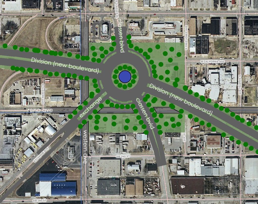
The group, Friends for a Better Boulevard, of which I am certainly informally a part of, has envisioned a grand entrance to downtown where people currently sit in traffic along Western. They are proposing the Market Circle, along the Boulevard at the Reno/Classen/Western intersections, and the Thunder Circle, along the Boulevard in between the Chesapeake Arena and new MAPS3 Downtown Park. In the Market Circle the pro-bono architects have envisioned an arch way that gives OKC the opportunity to realize a turn-of-the-century plan by legendary architect Solomon Layton (State Capitol, Colcord, Skirvin, et al.) to have a Veterans Memorial Arch in the middle of Lincoln Boulevard. Those plans, along with the Capitol dome (a bad idea) were never realized. However, often the best new plans incorporate good old ideas, that came about for a reason. This traffic circle proposal will catalyze a boom of dense development west of downtown and generate significant economic development for OKC. Here is an excerpt from a recent article by Lackmeyer on Film Row and west downtown's development boom (this quote is Film Row redeveloper Chip Fudge talking about several building projects and predicting that south of Film Row will be a hot spot):
With all this activity, and Devon Energy Center in the foreground, friends are no longer mocking Fudge for plowing his money into “skid row.”
“Life is good,” Fudge said. “My friends who thought I was nuts for doing this initially now think I'm brilliant. Really, I'm just lucky. We're continuing to buy property in the area. And if the boulevard (planned along the alignment of the old Interstate 40) goes in at ground level as I expect, I think the area south of here will be the next hot spot.”
Read more here.
There is also the matter of the Farmer's Market, which is what lies south of Film Row, and concurrently the city and a group of citizens are trying to revitalize. Currently it has been repurposed as an events center taking advantage of its beautiful mission-style architecture, but there may be plans in the future to bring back a permanent outdoor market and engage historic redevelopment in this area. The Farmer's Market is an extremely historic center of commerce for OKC, and my own grandfather used to work there long ago. In fact, back then, the entire clan worked there selling produce which was not a bad living back before WWII. The Farmer's Market was a magnet of middle class life in Oklahoma City back then, just as the once-beautifully landscaped Canadian River waterfront was with Wheeler Park and Delmar Gardens. This market-area masterplan seeks to bring back both the tranquility and the commerce:

Unfortunately for ODOT, all of these are things we are not willing to sacrifice just so that ODOT can pay somebody off and move on more easily to the next project. All of these visions, especially the hope for a grand entrance into downtown, and also the hope to revitalize the areas south of downtown such as the market area and the riverside, are all endangered by this elevated freeway plan. This is also a plan that was most recently articulated by highway engineers who weren't aware that the streetcar would run on rails in the Boulevard. How do you get through to these people, as oblivious as they are, aside from political means? At the state level it is time to pursue correcting and reforming ODOT, but in the interim, at the civic level, we have to engage to protect our city and any other plans ODOT simply isn't aware of.
Those seem to include the Downtown Elementary, the Downtown Streetcar, Farmer's Market revitalization, Core2Shore revitalization, Film Row/Arts District redevelopment, and the very idea of downtown development on the whole. All of these ODOT is either ignorant or hostile to, and all of these kinds of projects have proven to be the essential ingredients in the recipe for an OKC reborn. What does OKC reborn mean and why is it important? Because too many of us remember a river that had to be mowed, too many of us remember wrestling and minor-league arena football being the main attraction in town, too many of us remember Wal-mart being the only place to shop, and too many of us remember an OKC that was essentially no more than an extended truck stop between LA and Chicago. Today those are merely insulting reminders of how far OKC has come in its quest to justify itself as a "big league city" and even cast itself in similar fashion to truly "world-class cities."
The ODOT earthen ramp is not world-class, hell, it's not even bush-league. It is embarrassing. ODOT has pushed OKC around too much for the last two decades, and it's time for OKC to take a stand. They bulldozed all of Deep Deuce, the downtown black community, and built a suburban depressed freeway (I-235) where there used to be a dense, urban neighborhood. They forced the I-40 Crosstown Relocation against the city's will. Then, they decimated the railyard behind Union Station which will add billions in cost when we get around to building the commuter rail that is planned, which the city idly watched them do, while a few enraged citizens went away kicking and screaming (Tom Elmore). Now they are taking our best site for urban redevelopment and giving us a highway mound of dirt and grass that will have to be mowed while it isn't dead and brown, like grass all over Oklahoma.
This isn't the revenge of Tom Elmore. This is the culmination of ODOT's years-long recent legacy in Downtown OKC, and a decision that needs to be made whether we want to hear only ideas that come from highway engineers or if urban planners should also be brought into the fold. Urban planners and design specialists, being the folks who gave us entertainment in Bricktown and large-scale gentrification in what was left standing of Deep Deuce, Automobile Alley, and Mid-town. Today these areas are surprisingly decent and growing better with each new development, despite the unfortunate past these areas have endured until now. The choice seems pretty simple.